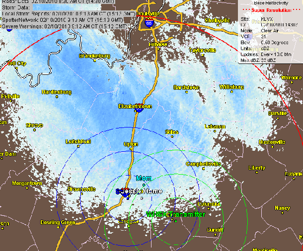
1pm - Wednesday, February 10th, 2011
11pm - Tuesday, February 9th, 2011
Snows' over folks. Last one of the year? Warmer pattern will set in next week. Temps will be cold tonight and even colder for Thursday night. Mid 30s for Friday, 40's on Saturday... AND .... 50's for Sun, Mon and Tue.
Friday: Sunny, with a high near 37. Wind chill values as low as zero. Southwest wind between 6 and 14 mph.
Friday Night: Mostly cloudy, with a low around 22. Southwest wind between 8 and 10 mph.
Saturday: Mostly sunny, with a high near 43.
Saturday Night: Partly cloudy, with a low around 28.
Sunday: Mostly sunny, with a high near 53.
Sunday Night: Partly cloudy, with a low around 34.
Monday: Mostly sunny, with a high near 53.
Monday Night: Partly cloudy, with a low around 32.
Tuesday: Mostly sunny, with a high near 54.
Tuesday Night: Partly cloudy, with a low around 34.
Wednesday: Mostly sunny, with a high near 53.
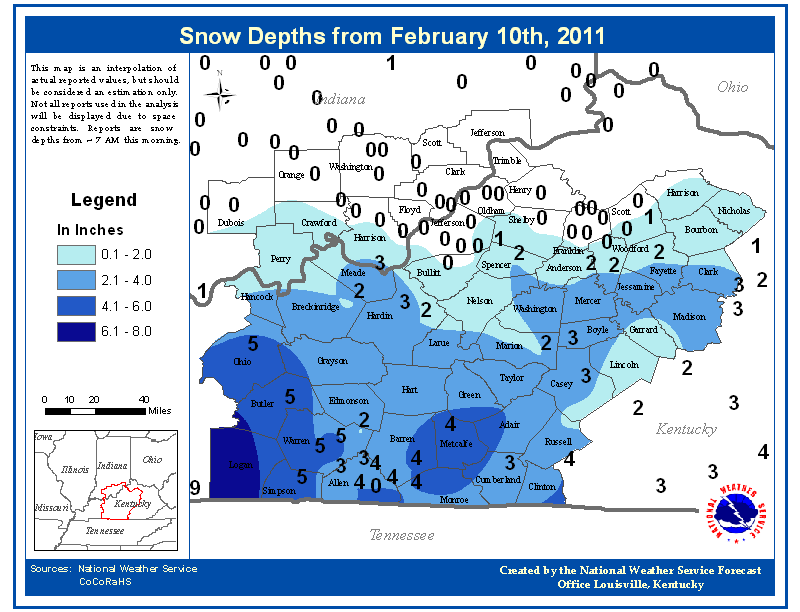
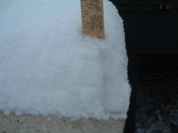
Snow on ground at Bowling Green/Official (this counts some from earlier in the week): 5 inches
Closings-Cancellations-Delays... Click Here for the 991 & WLOC Snow Watch Page
Send weather info (snow totals) and other newsworthy pictures to: 991@scrtc.com or wloc@scrtc.com
Chris Jessie
12 Noon - Tuesday, February 9th, 2011
Snow continues... more this afternoon and tonight. Still watching to see the major moisture flow makes it this far north. If it does, we could be in for several more inches of snow for this evening and tonight. Mid west is snowed in today.
5am - Tuesday, February 9th, 2011
Plenty of cold air for today and tonight's snow potential... How much moisture makes it this far north and east is the question...??? Discussion coming a little later this morning. Radar is already showing returns, even though the indicated precip as of about 5am is not reaching the ground. A few school closings are coming in.
Closings-Cancellations-Delays... Click Here for the 991 & WLOC Snow Watch Page
Send weather info (snow totals) and other newsworthy pictures to: 991@scrtc.com or wloc@scrtc.com
Chris Jessie
8am - Tuesday, February 8th, 2011
Most of the area picked up 2-3 inches late afternoon and evening Monday. The actual snow total is higher because much of it melted as it began falling in the afternoon hours. Most all the county school systems are closed around the region.
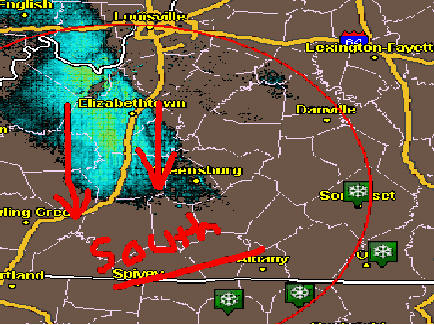
Discussion on Wednesday System:
We're on the north sector of the precip. With temps only getting to about 30 for a high, all precip for this event should be snow. The Upper Cumberland is looking a little warmer for Wednesday afternoon evening.
Temps Mid-day Wed... 1pm... then 4pm... notice the warming into the Upper Cumberland.
Precip Mid-day Wed... (Noon to 6pm precip and then 6pm to Midnite precip)
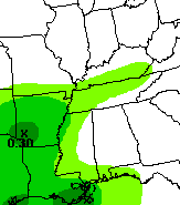
I still think an inch or so Wednesday afternoon and then about 2 in the evening. So.. 3-5 total. This is based on a higher snow/liquid ratio. I think they could be closer to 14:1 than 10:1... that helps up the accumulations.
I'll post more later today after new runs come out.
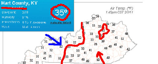
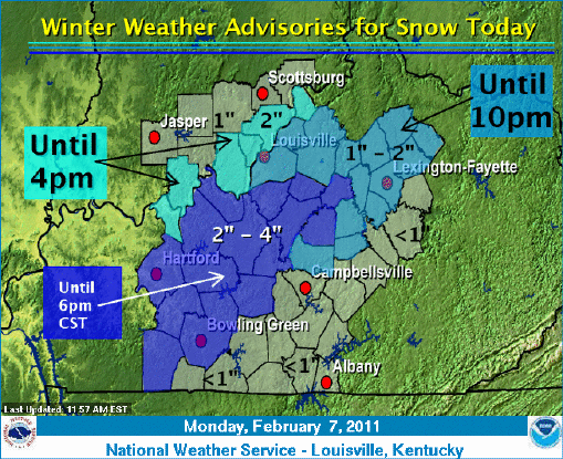
2pm - Monday, February 7th, 2011
Snow still holding along that I-65 area... Moisture is moving north and east... Will likely be gone by the time temps really drop enough for significant accumulation. Heavier totals will be along and west of I65, where a lot of areas already have snow cover from this morning.
11am - Monday, February 7th, 2011
Quick Post...
Temps west of I65 are not where the forecast had them for today. Temps near Columbia and in Casey County climbed to 40... in between is a gradient. Snow to our west is also a little heavier than expected.
Several schools are dismissing around the western part of the listening area.
Closings-Cancellations-Delays... Click Here for the 991 & WLOC Snow Watch Page
Send weather info (snow totals) and other newsworthy pictures to: 991@scrtc.com or wloc@scrtc.com
Chris Jessie
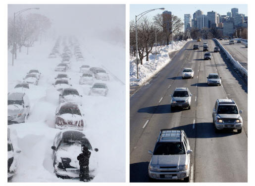
8am - Friday, February 4th, 2011
Check out this traffic net pic from Chicago from this week.
Many of the people in the left pic say they ignored warnings to go home earlier and not to take the lake shore route that ended up trapping their vehicles.
7am - Friday, February 4th, 2011
Winter Weather Advisory tonight for areas along I65 and to the north and west. Snow late evening/after midnite will end by Saturday morning. Temps will rise into the mid 30's but may be held back with some snowpak. Roads should be in good shape by mid- morning as solar effects take hold. Secondary roads may take a little longer to melt off.
2+ inches possible in Advisory area. 1-2 inches for areas to the south and east of the advisory.
Next weeks snow?? Valentine weekend storm?? Discussion later today.
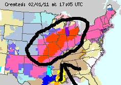
11am - Tuesday, February 1st, 2011
Cold..... brrrrrrrr.... Wind-chill factor..... brrrrrrrr.
Winds will really kick it up later this afternoon. Wind Advisory through Wednesday afternoon. Temps will drop QUICKLY after the front pushes through and light snow will be possible. A dusting is the target for most of us. Winds will also make it a "blowing snow" type setup.
From Texas borders up to Michigan/Canada... BLIZZARD Warnings are in place. This is not a common event... such a widespread Blizzard type storm is rare.
Good news for the "No-Snowers" here.... the ridge over the SE US will block the southern part of this storm from advancing east... it will ride over southeast for the most part.
Some schools may end up being out on Wednesday... more likely for north/west counties in our area. So the question remains: Will the kids get in a full week for the first time since early December?
Closings-Cancellations-Delays... Click Here for the 991 & WLOC Snow Watch Page
*** Send In Closings/Cancellations/Delays/Updates By Clicking Here
Send weather info (snow totals) and other newsworthy pictures to: 991@scrtc.com or wloc@scrtc.com
Chris Jessie
1pm - Monday, January 31st, 2011
Bye-bye January... We'll finish the month with higher than average snow totals and when the numbers are finalized tomorrow, we'll see it as one of the snowiest in recent decades for the overall month.
The nasty storm in the mid-west will have snow on the north half, well above us here in Central / Southern Kentucky. If you are traveling into Central Indiana/Illinois/Ohio it will be difficult.
We will see a lot of rain and very windy conditions Tuesday night/Wednesday. Some snow showers will be on the back side of the storm late Tuesday and Wednesday as temps plunge. The winds will make it seem VERY cold, although temps will not be frigid by the thermometer's standard.
We are not expecting any accumulations out of this system, but maybe a dusting... and blowing snow on Wednesday.
Will schools around the area actually get a full week in? Wednesday would be the day, if not.
Closings-Cancellations-Delays... Click Here for the 991 & WLOC Snow Watch Page
*** Send In Closings/Cancellations/Delays/Updates By Clicking Here
Send weather info (snow totals) and other newsworthy pictures to: 991@scrtc.com or wloc@scrtc.com
Chris Jessie
2pm - Wednesday, January 26th, 2011
Temps are in the upper 20's. Re-freezing is starting to take place now that the height of the day has passed. Just a few flurries at most for the remainder of the day and into tonight. Warmer temps for highs later this week and weekend. No more accumulating snow in the 7-day outlook.
7am - Wednesday, January 26th, 2011
Had a great time yesterday with the Edmonton-Metcalfe Chamber of Commerce radio membership drive... CD Day. Thanks to all who joined/renewed membership.
Snows still coming down. Still think snows will end up being lighter than the original forecasts. Temps overnight did not drop beyond 32 here locally. They dipped more to our west/north.
Updates later.
12 Noon - Monday, January 24th, 2011
Warmer temps today: mid-40's
Above Freezing Tonight: low-33/34
Tuesday: 40 and falling in the evening... but how far and how quick?
Now, for Tuesday night/Wednesday...
The maps above are 6-hour QPF estimates for (local times) Noon Tue, 6p Tue, Midnite Wed & 6a Wed.
The maps below are corresponding temp estimates.
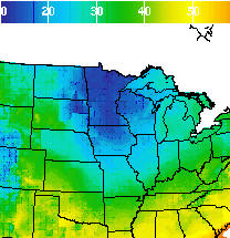
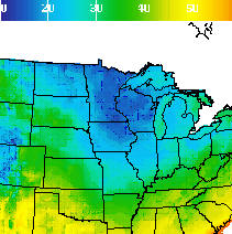
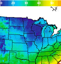
You've probably gotten heard various forecasts at this point calling for 1-2 inches of snow, but with the mid-day data, things are just looking too warm. Temps won't been at freezing until maybe near midnight going into Wednesday. By then, most of the moisture would be gone.
If you love snow, you're hoping for a more aggressive cold push and your hoping for the track to shift just about 25-50 miles north. Should these scenarios combine, a 4-6" snow event could take place for the Heart of Kentucky. Under this circumstance, a wet snow would be likely... well under a 10:1 snow to liquid ratio. However... I'm going very conservative at this point, I believe the current forecasts are being generous with snow at this point.
Closings-Cancellations-Delays... Click Here for the 991 & WLOC Snow Watch Page
*** Send In Closings/Cancellations/Delays/Updates By Clicking Here
Send weather info (snow totals) and other newsworthy pictures to: 991@scrtc.com or wloc@scrtc.com
Chris Jessie
7am - Friday, January 21st, 2011
Cold... 11 this morning at the studio. Roads are packed snow/ice layer covered. Grated roads will be very slick for a while this morning as the sun starts to melt ice... nothing slicker than wet ice.
Here's the assessment from yesterday's forecast/snow... Forecast was pretty close.
Timing yesterday was close, too. I had said several times on broadcasts and here that road conditions would deteriorate as temps dropped by about 3pm. The kink in the forecast yesterday was the warm air wedging into Southern Kentucky. That took place in Eastern Kentucky, and not as far west as I had anticipated... Knox County Mesonet reported 47 at around 2pm (see below). We only recorded 34 here at the studio for a high.. forecast was for 37. Doesn't sound like a lot (and normally we wouldn't be too disappointed by 3 degree forecast difference), but in the case with snow in the afternoon, it is a very important forecast variable. It allowed snow and not rain for much of our central and north/west listening areas. I-65 had a number a weather related accidents by mid-afternoon. Most other roads were simply wet until about 2-2:30, then the heavier snows started to accumulate on paved surfaces (later in the east).
Last night, clearing occurred pretty early in the west of our area. Helped temps fall more quickly.
Forecast: Today will struggle to get into the 20's. Tonight will be near single digits... localized area may see single digit lows.
Focus now turns to early next week.... snow/rain/mix? More details coming with an afternoon post.
Closings-Cancellations-Delays... Click Here for the 991 & WLOC Snow Watch Page
*** Send In Closings/Cancellations/Delays/Updates By Clicking Here
Send weather info (snow totals) and other newsworthy pictures to: 991@scrtc.com or wloc@scrtc.com
Chris Jessie
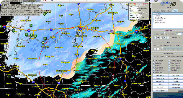
2:30pm Thursday, January 20th, 2011
Temps have topped out for the North and West parts of our area... starting to fall off now... About 30 minutes ahead of my expectations from yesterday and this morning's posts.
As of 11am:
As of 2:30pm:
The colder plunge is stronger than anticipated for today... Warm southern wedging is taking place further east than the models have shown. Look at Knox County... 47 degrees! 40's all over eastern KY.
Colder air pushing in may make the snow ratios go up. Starting out, 10:1 the snow to rain... If this "cold" pushes a bit more quickly this evening we could go up to 12 or 15:1... If there is enough moisture to support a burst of snow, it could be heavy and accumulate very quickly.
Closings-Cancellations-Delays... Click Here for the 991 & WLOC Snow Watch Page
*** Send In Closings/Cancellations/Delays/Updates By Clicking Here
Send weather info (snow totals) and other newsworthy pictures to: 991@scrtc.com or wloc@scrtc.com
Chris Jessie
1pm Thursday, January 20th, 2011
Some moderate snow being reported in Hart County, Edmonson County and Warren County... Ground temps still seem to be above 32 as everything is melting on paved surfaces, even though snow is sticking to elevated surfaces. I still think that roads will be ok until about the 3pm mark.
Closings-Cancellations-Delays... Click Here for the 991 & WLOC Snow Watch Page
*** Send In Closings/Cancellations/Delays/Updates By Clicking Here
Send weather info (snow totals) and other newsworthy pictures to: 991@scrtc.com or wloc@scrtc.com
Chris Jessie
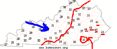
11am - Thursday, January 20th, 2011
I'm guilty of localism... :o)
I've gotten several e-mails this morning about the afternoon outlooks... keep in mid that the further north/west you go, the lower the temp scale and the opposite to the south/east... areas from around Bardstown to E-town to Leitchfield will be right on that line of temps that allow for snow all day. Some of these places have already seen snow from this morning... I still believe that Warren, Barren, Hart, Green and areas to the south will not be greatly affected by snow until later this afternoon. Temps are already at 32-33 for these areas (34/35 toward state line), so even if snow does fall (unless it's HEAVY), it should not be a problem on the roads until temps start dropping later this afternoon.
Closings-Cancellations-Delays... Click Here for the 991 & WLOC Snow Watch Page
*** Send In Closings/Cancellations/Delays/Updates By Clicking Here
Send weather info (snow totals) and other newsworthy pictures to: 991@scrtc.com or wloc@scrtc.com
Chris Jessie
6am - Thursday, January 20th, 2011
Overnight temps did not fall into the upper 20s as expected. 32-33 locally as of 6am. Any snow showers this morning will not likely impact roadways. Temps will vary, (colder) from the north/west to the (warmer) south/east. That is also how the accumulation breakdown will likely occur. For the Heart of Kentucky, temps well into the 30s won't drop until after about 3-4 pm, so paved surface accumulations won't mount up until then. Grassy areas may receive accumulations a little earlier in the afternoon.
Closings-Cancellations-Delays... Click Here for the 991 & WLOC Snow Watch Page
*** Send In Closings/Cancellations/Delays/Updates By Clicking Here
Send weather info (snow totals) and other newsworthy pictures to: 991@scrtc.com or wloc@scrtc.com
Chris Jessie
9pm - Wednesday, January 19th, 2011
Quick post for tonight guys and gals...
Copied from my FaceBook post:
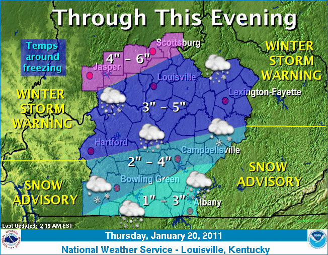
Flurries overnight then a few snow showers for Thurs morning... temps rise above freezing by about 11am with a high near 37 by about 3pm... temps drop quickly afterwards... snow 2-3 inches by Fri morning... localized higher totals possible... more snow north & less snow south... winter advisory for socentral ky & a winter storm warning for nocentral kentucky for thurs/into fri.
Closings-Cancellations-Delays... Click Here for the 991 & WLOC Snow Watch Page
*** Send In Closings/Cancellations/Delays/Updates By Clicking Here
Send weather info (snow totals) and other newsworthy pictures to: 991@scrtc.com or wloc@scrtc.com
Chris Jessie
12 Noon - Tuesday, January 18th, 2011
Everybody is looking ahead to Thursday... But real quick for tonight: Dusting of snow/sleet at most... Maybe some freezing drizzle... Slick spots will be possible, especially on overpasses and elevated surfaces. Since roads are wet today (and there have been heavy enough rains to actually clean the salt off of most of the surfaces), no pre-treat can go down. So, with temps in the mid-upper 20's overnight, there may be a few slick roads.
Now for Thursday... More consensus now about snows to the north. For SoCenKy, there is uncertainty about Thursday highs.... a tough variable to nail down (ground temps, too). I'm still having trouble seeing enough moisture for major accumulation AFTER the change over to snow. This is basically a guestimate for Central Kentucky... Metcalfe/Hart/Barren/Green/Adair... While areas to the north may see more snow and areas near the KY/TN border see more rain. It's hard to draw the rain-snow line right now for Thursday. Take note that as of right now, our area forecast high is 40-41. Thursday afternoon late, overnight and early Friday morning seem frame the window for timing of snow at this point.
Here is this morning's NWS statement concerning our area:
INCLUDING THE CITIES OF...PAOLI...SALEM...SCOTTSBURG...MADISON...
JASPER...MARENGO...TELL CITY...CORYDON...NEW ALBANY...
JEFFERSONVILLE...HAWESVILLE...HARDINSBURG...BRANDENBURG...
BEAVER DAM...LEITCHFIELD...ELIZABETHTOWN...FORT KNOX...
MOUNT WASHINGTON...SHEPHERDSVILLE...LOUISVILLE...LA GRANGE...
BEDFORD...NEW CASTLE...SHELBYVILLE...FRANKFORT...GEORGETOWN...
CYNTHIANA...TAYLORSVILLE...LAWRENCEBURG...VERSAILLES...
LEXINGTON...PARIS...CARLISLE...BARDSTOWN...SPRINGFIELD...
HARRODSBURG...NICHOLASVILLE...WINCHESTER...HODGENVILLE...
LEBANON...DANVILLE...LANCASTER...RICHMOND...MORGANTOWN...
BROWNSVILLE...MUNFORDVILLE...GREENSBURG...CAMPBELLSVILLE...
LIBERTY...STANFORD...RUSSELLVILLE...BOWLING GREEN...FRANKLIN...
SCOTTSVILLE...GLASGOW...TOMPKINSVILLE...EDMONTON...COLUMBIA...
JAMESTOWN...BURKESVILLE...ALBANY
459 AM EST TUE JAN 18 2011 /359 AM CST TUE JAN 18 2011/
...ACCUMULATING SNOW EXPECTED ACROSS THE AREA THURSDAY THROUGH
THURSDAY NIGHT...
A WINTER STORM SYSTEM WILL OVERSPREAD THE AREA FROM WEST TO EAST
ON THURSDAY. LIGHT TO MODERATE SNOW WILL BEGIN TO MOVE INTO
SOUTHERN INDIANA EARLY THURSDAY MORNING. PRECIPITATION WILL THEN
SPREAD EASTWARD ACROSS CENTRAL KENTUCKY THROUGH THE LATE MORNING
AND AFTERNOON HOURS. THIS SYSTEM WILL QUICKLY PUSH EASTWARD
OVERNIGHT WITH SNOW EXPECTED TO COME TO AN END BY FRIDAY MORNING.
THIS STORM SYSTEM WILL HAVE A MIXTURE OF PRECIPITATION TYPES AS
WARM AIR WILL NOSE INTO SOUTH CENTRAL KENTUCKY. COUNTIES NEAR THE
BORDER WITH TENNESSEE WILL LIKELY SEE PLAIN RAIN DURING THE
AFTERNOON HOURS ON THURSDAY WHILE FURTHER NORTH A MIX OF RAIN AND
SNOW WILL BE POSSIBLE. AREAS GENERALLY NORTH OF THE BLUEGRASS
PARKWAY LOOK TO SEE ALL SNOW. AS COLD AIR FILTERS IN LATE
THURSDAY AFTERNOON THROUGH THURSDAY EVENING A CHANGE OVER TO ALL
SNOW WILL OCCUR.
THOUGH THERE IS STILL SOME SPREAD IN PRECIPITATION AMOUNTS WITH
THIS SYSTEM...IT LOOKS ONE TO THREE INCHES OF SNOW ACCUMULATION
WITH ISOLATED HIGHER AMOUNTS WILL BE POSSIBLE ACROSS THE AREA. THE
GREATEST ACCUMULATIONS WILL BE ACROSS SOUTHERN INDIANA AND NORTH
CENTRAL KENTUCKY. THIS SNOWFALL WILL LIKELY AFFECT TRAVEL ACROSS
THE REGION THURSDAY AFTERNOON AND NIGHT.
AS WITH ANY SYSTEM OF THIS TYPE...THE AMOUNT OF WARM AIR PUSHING
IN FROM THE SOUTH WILL HAVE A BIG IMPACT ON SNOW ACCUMULATIONS. BE
SURE TO CHECK BACK FOR THE LATEST DEVELOPMENTS ON THIS SYSTEM.
$$
Closings-Cancellations-Delays... Click Here for the 991 & WLOC Snow Watch Page
*** Send In Closings/Cancellations/Delays/Updates By Clicking Here
Send weather info (snow totals) and other newsworthy pictures to: 991@scrtc.com or wloc@scrtc.com
Chris Jessie
10:30am - Monday, January 17th, 2011
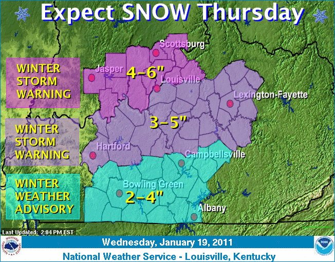
A lot of focus is now turning to Thursday's Forecast (I'm not overlooking Tuesday -- See below). Even the NWS is uncharacteristically upping the snow chance for 4 days out. The Central Kentucky Region has 70% snow chance according to the morning NWS outlook. Here is the 9am update for later this week:
Thursday: Snow likely. Cloudy, with a high near 36. Chance of precipitation is 70%.
Thursday Night: Snow likely. Mostly cloudy, with a low around 20. Chance of precipitation is 70%.
Friday: Scattered flurries. Partly sunny, with a high near 27.
More on the snow in just a sec... The most common aspect of the models is the intensity of the cold air moving in. Friday/Saturday will likely be the coldest temps of the season, so far. Storm track is the question. I still see more northern push with the heaviest snows beyond Louisville... Maybe even along the same track from last week's huge Indiana snow. However, if the next couple of day's models trend south... Potential is there for a major snow even here in Central Kentucky. Even if the track trends south, there are still several variables (most obvious: how far south) that must get in-tune for a big snow event to take place for our area.
Also want to mention Tuesday night. On the backside of the rain, snow showers will be possible. I temps look like upper 20's... certainly below freezing. While little accumulation is expected, there could be enough moisture remaining for causing some minor travel issues on Wednesday morning.
Closings-Cancellations-Delays... Click Here for the 991 & WLOC Snow Watch Page
*** Send In Closings/Cancellations/Delays/Updates By Clicking Here
Send weather info (snow totals) and other newsworthy pictures to: 991@scrtc.com or wloc@scrtc.com
Chris Jessie
9am - Monday, January 17th, 2011
Late week outlook posting coming up in just a little bit.... interesting. Snow/Cold???
7:30am - Monday, January 17th, 2011
Some freezing drizzle being reported this morning across Edmonson/Hart/Barren Counties. Surrounding areas also showing frozen returns on radar. Be careful on the overpasses, especially. We will rise above the 32 mark shortly this morning. Highs will be in the lower-mid 40s around the region.
NWS Statement:
...LIGHT FREEZING RAIN...OR LIGHT SNOW POSSIBLE FOR A BRIEF
PERIOD THIS MORNING...
A WARM FRONT IS LIFTING NORTH ACROSS CENTRAL KENTUCKY WITH LIGHT
MIXED PRECIPITATION POSSIBLE THROUGH MID MORNING. SURFACE
TEMPERATURES ARE CURRENTLY JUST BELOW FREEZING AND ARE EXPECTED TO
RISE ABOVE FREEZING BY MID MORNING. AS THIS OCCURS...A BRIEF
PERIOD OF FREEZING RAIN AND LIGHT SNOW WILL BE POSSIBLE.
ACCUMULATIONS ON ROADWAYS ARE NOT EXPECTED AS PRECIPITATION IS
EXPECTED TO BE VERY LIGHT...ALTHOUGH A VERY THIN GLAZE OF ICE
CANNOT BE RULED OUT ON ELEVATED SURFACES OR SHELTERED AREAS
EARLY THIS MORNING. SURFACE TEMPERATURES ARE EXPECTED TO RISE INTO
THE LOW TO MID 40S BY LATE THIS AFTERNOON...WITH ANY THREAT FOR
FROZEN PRECIPITATION ENDING BY LATE MORNING.
6:30am - Thursday, January 13th, 2011
More snow showers overnight... moisture squeezing out with the cold temps. Dustings for most of the area overnight... flurries should taper off today.
After a quick shot of show showers on Saturday from a northern passing clipper, our next weather maker is looking more like a snow to rain type event. Leaning even more towards maybe all rain for late Sunday/Monday. I'll be posting more thoughts on the early week system a bit later today.
Enjoy another no-school day (for many of you)!!!
Closings-Cancellations-Delays... Click Here for the 991 & WLOC Snow Watch Page
*** Send In Closings/Cancellations/Delays/Updates By Clicking Here
Send weather info (snow totals) and other newsworthy pictures to: 991@scrtc.com or wloc@scrtc.com
Chris Jessie
5pm - Wednesday, January 12th, 2011
Schools are closed over much of the area for Thursday... Get the latest on the Snow Watch Page.
Closings-Cancellations-Delays... Click Here
Flip a coin... problem is it doesn't have more than two sides... that's the early next week storm prediction method at this point. As we look at the various model outputs for early week, there is almost no common ground except for the fact that they all predict precipitation for the Ohio and Tennessee Valley regions. Temp zones are not in agreement which also means the precip types are also all over the board. I will say this: Various outputs suggest anything from the biggest snow of the year to a heavy rain event. Yes, there is a snow to rain and icing to rain interpretation, too. As I have been saying since Sunday, this is too far out and the current early next week forecasts only feature a shade of confidence. So --- To Be Continued.
Monday, I received an e-mail that asked why many of my posts look ahead to the next event as opposed to giving more attention to current weather or the "nowcast". I responded by writing back that so many people are technically inclined today... meaning that it's not to difficult to look up some basic terminology and see radar returns. (I will say that snow is the most difficult precip to do radar interpretation with.) So, if there's a large area of rain colored in over a map of Kentucky that features county boundaries, most people can translate that into basic concepts of time and movement... velocity... with relation to their location. My personal interest is typically in manipulating and giving interpretation to data that most people don't care to do. That's how longer ranged forecasts are produced. I enjoy the challenge of working through a 3-7 day outlook and stacking it up to what actually gets recorded. In my opinion, that is the area of forecasting that has come a long way in improvement over the past decade. I address this question here and today because it is especially challenging during the winter months... And I don't mind the snow!... So... Bring it on!!!
Closings-Cancellations-Delays... Click Here for the 991 & WLOC Snow Watch Page
*** Send In Closings/Cancellations/Delays/Updates By Clicking Here
Send weather info (snow totals) and other newsworthy pictures to: 991@scrtc.com or wloc@scrtc.com
Chris Jessie
7am - Wednesday, January 12th, 2011
Flurries this morning... You'll come up on areas of drifting snow as you travel most of the area roads. Remember that even though roads look wet or clear, you can come up on these blowing snow areas without any reaction time to slow down. 24 for a high today.
Weekend/Monday... snow, rain or ice???... still not a lot of agreement on NAM/GFS models for this one. QPF (total moisture) is showing some consistency, but the precip types are all over the place. So, maybe more model consistency will begin to show up tomorrow or Friday about Sunday/Monday, particularly.
Closings-Cancellations-Delays... Click Here for the 991 & WLOC Snow Watch Page
*** Send In Closings/Cancellations/Delays/Updates By Clicking Here
Send weather info (snow totals) and other newsworthy pictures to: 991@scrtc.com or wloc@scrtc.com
Chris Jessie
6pm - Tuesday, January 11th, 2011
Most people are surprised to know that much of our local area has received nearly 2 inches of snowfall since last night. The solar energy from today helped to melt a lot of it, so the 2 inches never showed up on the ground at the same time as accumulation.
Off and on snow showers will be in the forecast for tonight. A quick dusting to 1/4 inch will be common with these snow showers. Flurries may linger into Wednesday morning. Most area schools have already called off classes. See our Snow Watch/Weather Watch page for more on closings.
Closings-Cancellations-Delays... Click Here for the 991 & WLOC Snow Watch Page
*** Send In Closings/Cancellations/Delays/Updates By Clicking Here
Send weather info (snow totals) and other newsworthy pictures to: 991@scrtc.com or wloc@scrtc.com
Chris Jessie
7am- Tuesday, January 11th, 2011
Light snow continues with heavier snow E-town - North... NEWS Louisville forecast estimates for today...
5am - Tuesday, January 11th, 2011
Light Snow across the region...
With temps in the upper 20's near 30, most treated roads are wet. However, any heavier bursts of snow may cause them to become covered as we go through the rush hours.
Heaviest accumulations today are still expected to be to our north. Around 1 inch total daytime accumulation through the Heart Of Kentucky.
Closings-Cancellations-Delays... Click Here for the 991 & WLOC Snow Watch Page
*** Send In Closings/Cancellations/Delays/Updates By Clicking Here
Send weather info (snow totals) and other newsworthy pictures to: 991@scrtc.com or wloc@scrtc.com
Chris Jessie


.png)
10:20am - Friday, March 12th, 2010
1113 AM
HAIL
12 NW CAMPBELLSVILLE 37.47N 85.50W
03/12/2010 E1.75 INCH TAYLOR
KY EMERGENCY MNGR
COVERED THE
GROUND ON HWY 210 ON THE LARUE GREEN COUNTY
LINE
10am - Friday, March 11th, 2010
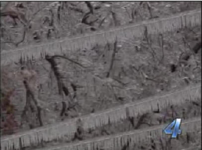
Strong storms passing through parts of our area.... lots of hail being reported... not so much large in size but just a LOT of it. Ground reported covered in parts of Northern Metcalfe County, South Eastern Hart County and South Western Green County.
Send weather info and other newsworthy pictures to: 991@scrtc.com or wloc@scrtc.com
Chris Jessie
7am - Wednesday, March 3rd, 2010
Hopefully February is an indicator for severe weather and tornado activity for the year. There were NO TORNADO reports from the National Weather Service anywhere in the US during the month.
Yesterday afternoon's 3.7 earth tremor centered in Missouri is being reported as noticed from as far away as Indianapolis and Lexington. The USGS says the origin of the quake was just over 5 miles below the surface. In geological terms, this is a very shallow quake. For comparison, the quake in Chile last week was over 20 miles below the surface. If you look at historical data, there is a correlation of quakes happening close together as the earth stresses. There have been three major quakes in the last couple of months around the world (that are relevant to intermittent earthquake discussion... there are many places in the world where earth quakes are very common). While we don't deal with tsunami warnings and mudslides, we are within the local grasp of the New Madrid Seismic Zone... which is responsible for one of the largest earthquakes ever recorded. The tremor should certainly be used as a reminder to be prepared... check on your emergency plan... consider your insurance plans, as most do not include earthquakes under standard coverage.
A warm up for the weekend....
60 by Sunday. Relatively calm weather will be the theme through the
weekend. Enjoy the spring appetizer... remember winter isn't
over. :o)
Send weather info and other newsworthy pictures to: 991@scrtc.com or wloc@scrtc.com
Chris Jessie
7am - Tuesday, March 2nd, 2010
Tornado Drill.... Today at 9:07am, Central Time.
This drill will be presented just as a real Tornado Warning. The warning will not go out with a "Test" header or closing. We will make live announcements before and after the drill. The fact that the event will be a LIVE drill means that you'll likely hear community sirens/alarms at that time, too.
Send weather info and other newsworthy pictures to: 991@scrtc.com or wloc@scrtc.com
Chris Jessie
1pm - Monday, March 1st, 2010
March in like a lamb.... we're hoping that the second half of the statement doesn't come true. I'd like to see it go out like a lamb, too.
Remember that Tuesday morning at 9:07am Central time is set for a statewide LIVE tornado drill. The LIVE portion of the drill means that it will be a TEST, but all media outlets will say TORNADO WARNING, just like the real thing. Usually a test is a relay from station to station and from the Weather Service to Weather Radios that says, this is a test of the Emergency Alert System. Tomorrow's test will not say a test... It will be a "run through" of a real warning. Kentucky and the Weather Service received special permission from the FCC to conduct this real working test. Be sure you turn your weather radio on and check the batteries. You should also check your settings to be sure you are getting the proper NWS signal and have the proper areas programmed in. I recommend the ALL setting for warnings. Even though your county may not be a Warned area, if you hear the county to your West (for example) in under a warning, chances are that weather is headed you way... especially for tornados/thunderstorms/squall lines. If you do not receive the warning at 9:07am tomorrow morning, double check your radio and have it check out by a qualified person. I'll be glad to provide that service to anyone locally.
Now... a few snow flurries/rain showers will be in store for us as we head to the middle of the week.
Areas to our south and west are seeing the post precip at this point. Most of the moisture will stay to our south and scoot across the Gulf States, then turn up the East Coast.
A warm up is in store for the weekend.... mid/upper 50's by Sunday.
Send weather info and other newsworthy pictures to: 991@scrtc.com or wloc@scrtc.com
Chris Jessie
8:30am - Thursday, February 25th, 2010
Snow is tapering off... should be finished with accumulations for the day.
Closings-Cancellations-Delays... Click Here for the 991 Snow Watch Page
Send weather info and other newsworthy pictures to: 991@scrtc.com or wloc@scrtc.com
Chris Jessie
7:30am - Thursday, February 25th, 2010
Heavier snow showers overnight have accumulated as much as 1-2 inches over portions of the region.
The snow showers on radar above are pushing off to the South. Another inch may be expected with this patch of snow.... Southern Hardin, Northern Hart and we'll see how far it goes after that.
Lots of Closings and Delays...
Closings-Cancellations-Delays... Click Here for the 991 Snow Watch Page
Send weather info and other newsworthy pictures to: 991@scrtc.com or wloc@scrtc.com
Chris Jessie
6am - Monday, February 22nd, 2010
Weekend rains held off until Sunday night... but a lot of it dropped in some areas. I had just under an inch overnight in the backyard. Some brief gusty winds were also experienced overnight.
We sure hope you enjoyed the 60+ temps on Saturday and Sunday. Enjoy today's temps, too... because Tuesday, we're back to reality.
Snow showers for Tomorrow and Wednesday. No accumulations are expected. A warm up is on the way for the weekend.
Long range says another cold shot of air as we begin March for the first part of next week... we'll see.
Send weather info and other newsworthy pictures to: 991@scrtc.com or wloc@scrtc.com
Chris Jessie
2:30pm - Thursday, February 18th, 2010
Temps this weekend will be too warm to provide snow. The exception will be overnight/early morning hours on Saturday. Rain may mix with snow at those times to our north, especially. Surface temps may allow for light grassy accumulations in northern portions of the region early Saturday morning. The temp maps from yesterday's post are still very close to the current forecast. In order for anything to change on this, a drastic shift will have to take place of the storm track. Snow line will be well into Indiana for this one.
Don't get too excited about a warm up. Mid week we'll chill back down just a bit, ahead of the next system. I expect that to affect our weather by about this time next week. Looks like another artic shot may be on the way at that point. It's still way too far out to pin anything up for expectations, but a general model agreement is out there for another cold snap and maybe some additional snow.
Enjoy the rain this weekend! (I'd rather it be snow than winter soup.)
Closings-Cancellations-Delays... Click Here for the 991 Snow Watch Page
Send weather info and other newsworthy pictures to: 991@scrtc.com or wloc@scrtc.com
Chris Jessie
8am - Wednesday, February 17th, 2010
I had aimed to post some thoughts (yesterday) on the upcoming weekend systems. There are two to consider. I am tending to lean toward a rain event, which is really accented in the NAM models. Here are some HPC "cocktails" that are blending some of the various models together, but even these are following more along the lines of the NAM.
On the left... HPC's precip probability. On the right... high temps for Saturday.
Notice the upper 40's are just across the Tennessee border. This has Saturday highs in the mid 40's for South Central Kentucky.
The next set contains the same maps, only these are for Sunday.
Sunday, HPC backs off quite a bit on the moisture and indicates a continuing retreat of cold air. The yellow's on the temperature map indicate 45-50. The light orange in middle Tennessee indicate 50-55.
I didn't post the low temp maps, but they do fall into the upper 20's a and lower 30's for the weekend lows. I am still not convinced there will be enough cold air to support snow at the surface.
A look at the 850mb temp chart does put us on the freezing line. The 0 (c) and just below line runs right through Southern Kentucky for Saturday 12z. Based on this forecast, air aloft will allow for snow development. But.... as noted above, it may change to rain or a mix in the lower levels. Certainly, the surface temps will be less favorable for accumulation.
I would like to say that this is still a low confidence forecast. Many of the models are in agreement on precip, but vary on the temperature conditions.
I'm still going with mostly rain for Southern Kentucky. Some night time snow may be possible.
The Sunday-Monday system still a bit too far out... but I will say that temp trends point toward rain from this point.
Closings-Cancellations-Delays... Click Here for the 991 Snow Watch Page
Send weather info and other newsworthy pictures to: 991@scrtc.com or wloc@scrtc.com
Chris Jessie
7am - Tuesday, February 16th, 2010
Lots of snow showers this morning. As we said yesterday, lots of these snow showers have been pushing through on and off since the main snows moved through. With the colder temps, the snows mount up quick. We've seen around 1 additional inch total from these passing snow bursts. Expect these to continue, but they will become lighter as we head into evening.
Closings-Cancellations-Delays... Click Here for the 991 Snow Watch Page
Send weather info and other newsworthy pictures to: 991@scrtc.com or wloc@scrtc.com
Chris Jessie
6am - Monday, February 15th, 2010
Colder air is really pushing south and sinking in. This means a more dry type snow for today. Liquid / snow ratios may be up to 20:1. That means any heavy pockets of snow today could mount up very quickly.
Closings-Cancellations-Delays... Click Here for the 991 Snow Watch Page
Send weather info and other newsworthy pictures to: 991@scrtc.com or wloc@scrtc.com
Chris Jessie
4am - Monday, February 15th, 2010
Last night's changeover to snow took a lot longer than expected. A misty-fog-drizzle combination kept evertything wet past midnight. Snows didn't mount up in the early evening hours, opposite of the folks to our north, where snow pretty much accumulated since around noon on Sunday. A heavy band of snow just pushed through our area and there is one more larger band before we see a dry slot with the cold front.
After this next band, we'll see a temporary halt to the snow for this morning for just a bit, follwed by numerous pockets of snow throuought the day. During these bursts of snow, it is likely for a quick inch of snow or more to mount up. This on/off snow will last the better part of the day and into the evening hours. Flurries can be expected through the overnight and into Tuesday morning.
It also looks like temps will be a bit colder than previous forecast packages for tonight and Tuesday.
Another chance of snow late week/weekend??? We'll talk more, later.
Closings-Cancellations-Delays... Click Here for the 991 Snow Watch Page
Send weather info and other newsworthy pictures to: 991@scrtc.com or wloc@scrtc.com
Chris Jessie
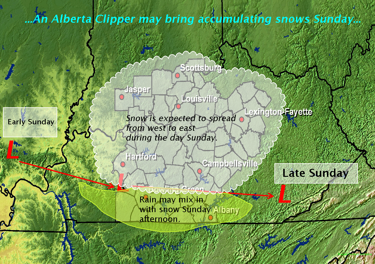
12 Noon - Sunday, February 14th, 2010
Updated snowcast... Totals have increased just a bit, especially to our east with the associated low expected to track through central and south-eastern portions of the state.
Though snow flurries are being reported heavier snows are still off to the west/north.
Temps may not get quite as warm as forecast for all of our region. The rain/snow line is still going to be tough to pin down. The changeover will be brief for most everyone (that has a changeover) in our area tonight, I believe. More rain is likely past the state border.
Travel will not likely be impacted until later this evening/overnight. Temps/solar leak/previous and pre-treated roads will certainly melt or be slush. Heavier snows tonight will most likely cover the roads. Look for a rough Monday AM drive. Heavier snows through the day and into the evening will likely make the afternoon drive pretty snowy, too.
Not sure on school issues for tomorrow. Many area systems had originally scheduled an off day for student's as President's Day. But, several systems had decided recently to use the day as a makeup. This snowcast will likely affect those plans for the schools deciding to go on Monday.
Closings-Cancellations-Delays... Click Here for the 991 Snow Watch Page
Send weather info and other newsworthy pictures to: 991@scrtc.com or wloc@scrtc.com
Chris Jessie
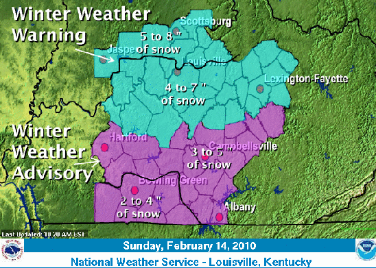
8am - Sunday, February 14th, 2010
From The National Weather Service Office - Louisville, KY for most of our area (see map below):
...WINTER
WEATHER ADVISORY IN EFFECT FROM 6 PM THIS EVENING TO
6 PM CST MONDAY...
THE NATIONAL WEATHER SERVICE IN LOUISVILLE HAS ISSUED A WINTER
WEATHER ADVISORY FOR SNOW ALONG AND SOUTH OF A LINE FROM BOWLING
GREEN THROUGH ADAIR COUNTY.
* TIMING: LIGHT SNOW IS LIKELY BY EARLY AFTERNOON...POSSIBLY
MIXING WITH OR CHANGING TO RAIN LATE THIS AFTERNOON. HEAVIER
SNOW IS EXPECTED TO DEVELOP AFTER MIDNIGHT AND CONTINUE THROUGH
LATE MONDAY MORNING.
* MAIN IMPACT: ONE TO 3 INCHES OF SNOW IS EXPECTED ACROSS SOUTH
CENTRAL KENTUCKY THROUGH MONDAY AFTERNOON.
* OTHER IMPACTS: ADDITIONAL SNOW SHOWERS MAY ADD UP TO ONE HALF
INCH MONDAY AFTERNOON.
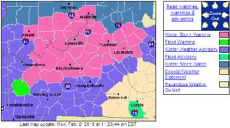
Concerning this weekend's storm.... The track has shifted again on the
latest model runs. there is now fairly good agreement on the different
runs. First off, take a look at the NWS Advisory/Warning map for late
today into Monday:
Now, here's the latest snowcast total map from NWS:
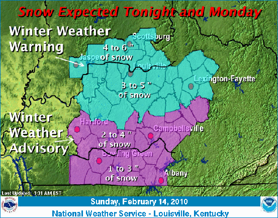
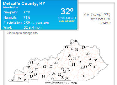
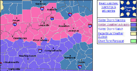
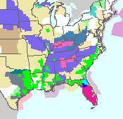
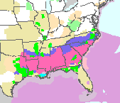
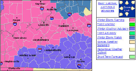
Temps are expected to head into the mid-30's today. That's going to push our overall snow forecast down for South Central KY. With that, expect our southern most counties to experience some rain mixed with snow this afternoon (especially for those counties in the 1-3" snow category). Still, there is a lot of uncertainty as we are dealing with two systems. One is to our north and will track across Central Kentucky this afternoon. The other is to our south, where winter advisories are again posted for northern parts of Mississippi, Alabama and Georgia. The next graphic shows Winter Storm Warnings in pink and winter weather advisories in purple.
As Always... Remember a change in the storm track only slightly can greatly affect snow totals in a particular area. Also, with dewpoints pretty high, the lower levels are moist enough to produce precip right away. The storm is not going to eat up moisture saturating the atmosphere. On a side note, some sleet may mix in at times this afternoon, though it shouldn't be a significant ice/sleet event.
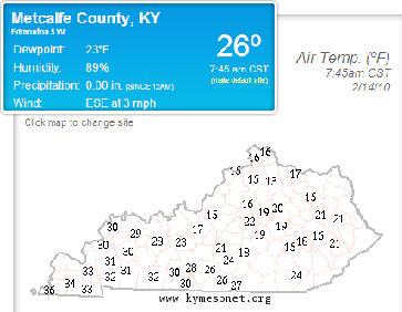
One more major factor for us (So-Cen KY)... Keep a close eye on the forecast temps. The north to south gradient will be tightly packed and again, we are right on that snow/rain line. On the upper side of that, add an inch of snow for this afternoon. Here are current mesonet temps and dewpoints as of about 8am.
We'll try to post throughout the afternoon.
Closings-Cancellations-Delays... Click Here for the 991 Snow Watch Page
Send weather info and other newsworthy pictures to: 991@scrtc.com or wloc@scrtc.com
Chris Jessie
9am - Friday, February 12th, 2010
A potent clipper system is forecast to move through the lower Ohio Valley on Sunday and Monday. This system will likely bring at least some snow accumulations to portions of our area. Snow totals will be highly dependent on the track of the system and will be further refined in future forecasts. The best time for snow accumulations will be Sunday afternoon through early Monday. Keep abreast of the latest forecasts if you have travel plans for the latter part of the weekend.
We'll have more on our winter weather for the weekend coming up.
Send weather info and other newsworthy pictures to: 991@scrtc.com or wloc@scrtc.com
Chris Jessie
7am - Friday, February 12th, 2010
Look at the southern us map... Yes, that's a winter storm warning for Florida.
...RARE
WINTER STORM IN PROGRESS FOR THE DEEP SOUTH...
WINTER STORM WARNINGS ARE IN EFFECT FROM NORTHEAST TEXAS EASTWARD
THROUGH MISSISSIPPI AND EXTENDING INTO WESTERN GEORGIA...INCLUDING
PARTS OF THE FLORIDA PANHANDLE. WINTER STORM WATCHES ARE IN EFFECT
FROM EASTERN GEORGIA INTO SOUTHEAST NORTH CAROLINA.
SNOW TOTALS THRU 7AM.
...LOUISIANA...
SHREVEPORT
2.0
VIDALIA
2.0
...MISSISSIPPI...
MCCOMB
3.0
NATCHEZ
1.0
JACKSON
0.9
....TEXAS...
DALLAS
11.2 GREATEST DAILY SNOWFALL EVER!
FORT WORTH
9.0
We'll have more on our winter weather for the weekend coming up.
Send weather info and other newsworthy pictures to: 991@scrtc.com or wloc@scrtc.com
Chris Jessie
7am - Thursday, February 11th, 2010
This week's storm beat the snow from 2 weeks ago. Official totals for Wednesday's snow came in at .6"... that puts the storm total at 5.7" since Monday. The previous storm totaled 5.5, officially. While we had more actual snowfall, we still never had as much on the ground at any given point as the last time. The rain and melting helped to keep that down.
Mon 2/8 - 2.0
Tue 2/9 - 3.1
Wed 2/10 - 0.6
Storm Total - 5.7
For the winter, we are at 14.1" of snow. To give you an idea of how far ahead of normal we are... normally at this point of the year, we have 7.2" of snow on the books... so we're almost doubled up.
Closings-Cancellations-Delays... Click Here for the 991 Snow Watch Page
Send weather info and other newsworthy pictures to: 991@scrtc.com or wloc@scrtc.com
Chris Jessie
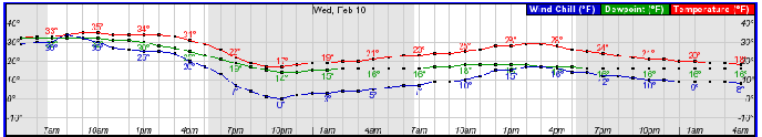
2pm - Wednesday, February 10th, 2010
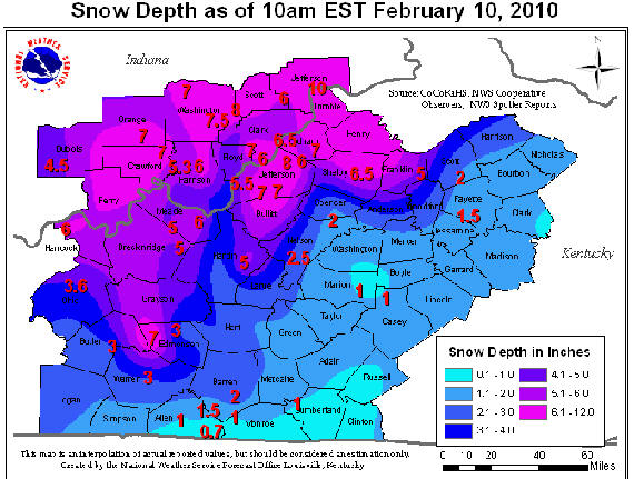
Totals were really scattered for the total storm.... again, the map is showing DEPTH as of 10am Eastern this morning. After today's numbers are made official, we'll have our snow total here.... at this point we're at 5.1" not counting today since midnight.
Closings-Cancellations-Delays... Click Here for the 991 Snow Watch Page
Send weather info and other newsworthy pictures to: 991@scrtc.com or wloc@scrtc.com
Chris Jessie
1pm - Wednesday, February 10th, 2010
Temps are mid/upper 20's and with the solar leak, we're seeing some nice road melting in the areas that have snow on the roads. Winds are also subsiding a bit. That is helping the wind chill feel. Temps are going to the mid teens tonight, and maybe a bit lower if we clear out early enough. Definitely re-freezing on back roads will take place tonight... and there will be slick spots on primary roads.
Situation for this weekend continues to build forecasting curiosity... north, south or down the middle? The moisture potential continues to grow, too... keep up with us on it.
Closings-Cancellations-Delays... Click Here for the 991 Snow Watch Page
Send weather info and other newsworthy pictures to: 991@scrtc.com or wloc@scrtc.com
Chris Jessie
9am - Wednesday, February 10th, 2010
Official readings for snow:
Monday before midnight: 2.0"
Tuesday (24hr reading): 3.1"
Today's total is still not official, yet.... so for the storm total at this point, we are at 5.1" of snow. This is our second 5"+ system in two weeks.... this seems like old times!!!
There's a nice patch of snow just to the north this morning that is training through Brandenburg to E-town and pushing SE.... we'll see what this does... It's dropping another inch or so in those areas.
ALSO.... don't get too worked up just yet, but the weekend activity may increase... we've been talking snow showers up to this point, but a more southern projection and added moisture may come into play for Sunday. Areas to the north and east may see a brief snow on Friday night/Saturday, but now that forecasters have turned attention to this next week, new runs from the various models are really all over the board at this point. There are several scenarios being tossed about at this point for snow. One projection puts snow down into mid state Mississippi and Alabama, then spreading snow all the way to the eastern coast. That's all still very early, but we will see more definitive forecast start to roll out with the next couple of packages heading into Thursday and Friday. Keep up with me on this one. I believe it will be another atypical setup and will be very difficult to pin down. So... expect anything.
More to come.
Closings-Cancellations-Delays... Click Here for the 991 Snow Watch Page
Send weather info and other newsworthy pictures to: 991@scrtc.com or wloc@scrtc.com
Chris Jessie
6:30am - Wednesday, February 10th, 2010
Cold temps have ice layered roads and then snow on top. The snow pack is actually helping with road traction in some cases. In either case, roads are very slick in the central and northern parts of our listening area. Even WKU Bowling Green is closed today.
More to come.
Closings-Cancellations-Delays... Click Here for the 991 Snow Watch Page
Send weather info and other newsworthy pictures to: 991@scrtc.com or wloc@scrtc.com
Chris Jessie
5pm - Tuesday, February 9th, 2010
Temps now dropping into the 20's across much of the area. Lots of reports of black ice on roads. Also, a few snow showers are dropping anywhere from a dusting to maybe even a 1/2 inch of snow this evening. This snow will be drier than earlier today, as it's on the back side now of the cold front. Also, winds are picking up. Blowing snow and bitter wind chills will be experienced overnight. Slush is freezing and lots of back roads are becoming glazed over. Expect overnight lows in the upper teens and wind chills near 0.
School closings are coming in.
Closings-Cancellations-Delays... Click Here for the 991 Snow Watch Page
Send weather info and other newsworthy pictures to: 991@scrtc.com or wloc@scrtc.com
Chris Jessie
9am- Tuesday, February 9th, 2010
Change over back to snow happened at our Horse Cave studio about 8am. Temp here says 31, Mesonet has 32 in Barren And Metcalfe sites. We won't get warmer. Slush is like a gel on the roads... it will freeze like that too, for those areas that are not plowed or traffic ridden. Solar radiation and treatments will help keep the roads wet until temps really drop. Winds will also pick up. Later this afternoon road conditions will deteriorate again... first on back roads and then on main roads as temps drop even more. Light snow showers could produce a dusting on top, but most accumulation is over.
For the Kids....!.... Build your snow man early if you have enough snow to do so... later, the snow will get a crunchy layer on the top after the temps drop.
Closings-Cancellations-Delays... Click Here for the 991 Snow Watch Page
Send weather info and other newsworthy pictures to: 991@scrtc.com or wloc@scrtc.com
Chris Jessie
5:30am - Tuesday, February 9th, 2010
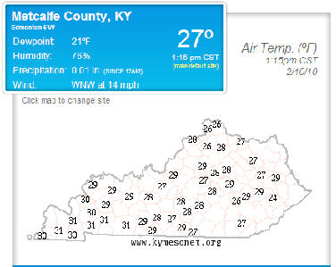
Temps observed from the Kentucky Mesonet around this morning for drive time:
As you can see... there's a big jump in the warm pocket. Look at Burkesville (33) and then Albany at (40).
Closings-Cancellations-Delays... Click Here for the 991 Snow Watch Page
5am - Tuesday, February 9th, 2010
The snow/rain line is really situated over Northern Barren and Metcalfe Counties in our region. I have 2.2 inches at my residence as of 4:30. Just 20 miles to my south, it is raining. The KY Mesonet temps are at or 1-2 degrees above freezing this morning. While several area schools are closed, others are still working on a decision. Temperature is a key here. The wet roads will get wetter this morning as rain continues. It may mix with frozen precip... sleet or snow... at times, especially to our south. But the big kicker later this morning and mid-day will be as the cold air pushes in. We will see that happen around lunch.... is my best estimate based on tempcasts.
Still, the temperature gradient from E-town to Columbia is very tight. E-town may see all snow today and temps not above 32, while temps may get as warm as 36-37 in the Eastern portion of our listening area. As you can see, temps will start dropping after Noon and probably be below freezing just in time for afternoon drive. With slush on the Northern roads and sith the rain in the area today, this could get real icy in a hurry. This afternoon will likely be more dangerous on the roads than this morning, especially back roads.
Also, we still expect some snow shower activity. A quick 1/4 of an inch or so could occur later this afternoon/evening, though we're not expecting major accumulations after the cold air pushes in.
Closings-Cancellations-Delays... Click Here for the 991 Snow Watch Page
Send weather info and other newsworthy pictures to: 991@scrtc.com or wloc@scrtc.com
Chris Jessie
9pm - Monday, February 8th, 2010
Temps are at or just slightly below freezing. Dangerous setup... we have precip of all forms reported around. Still looking at 1-3 inches locally expected by morning, then a change to rain then back to snow with re-freezing Tuesday night.
School closing are beginning to come in.
Closings-Cancellations-Delays... Click Here for the 991 Snow Watch Page
Send weather info and other newsworthy pictures to: 991@scrtc.com or wloc@scrtc.com
Chris Jessie
2pm - Monday, February 8th, 2010
After the NWS gang's conference call, I see now that this is really a 4-6 hour shot at best for getting this thing right. There is a much different scenario with the merging of two storm systems. We could get all rain tomorrow and then see the bottom fall out of the temps, or get a BIG dump of snow and then see the temps fall. Either way, we can be in for high winds and re-freezing late on Tuesday and into Wednesday.
I'll be watching snow rates along with the rain/snow line and keep posting.
Send weather info and other newsworthy pictures to: 991@scrtc.com or wloc@scrtc.com
Chris Jessie
1:30pm - February 8th, 2010
NWS conference call going on right now.... Highlights:
* Not a classic storm setup... not an extremely high confidence forecast
* Two storm systems are merging to create this setup
* Snow by 8pm (central) tonight in Bowling Green
* High winds for Tuesday/Tuesday Night.... 30mph +
* Highest totals will be in Southern Indiana/Northern Kentucky areas
* 6 or more hour event.... snow/rain line will creep north on Tuesday morning
* That line will significantly determine the amount of snow that accumulates
* Whatever we get will REFREEZE with much colder air bardging in. Road conditions (especially north) could be worse on Wednesday for ice than for Tuesday morning for snow
Send weather info and other newsworthy pictures to: 991@scrtc.com or wloc@scrtc.com
Chris Jessie
1pm - Monday, February 8th, 2010
Updated Advisory/Warning Map:
Send weather info and other newsworthy pictures to: 991@scrtc.com or wloc@scrtc.com
Chris Jessie
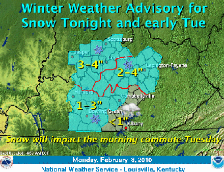
10:30am - Monday, February 8th, 2010
A line of Leitchfield to E-town to Lexington (and areas north) is now under a Winter Storm Warning. Metcalfe and other counties to the south and east are also now under a Winter Weather Advisory, as that is extended now to take into account a new forecast track.
..WINTER
WEATHER ADVISORY REMAINS IN EFFECT FROM 7 PM EST /6 PM
CST/ THIS EVENING TO 1 PM EST /NOON CST/ TUESDAY...
* TIMING: SNOW WILL DEVELOP THIS EVENING AND CONTINUE THROUGH
MIDDAY TUESDAY OVER PORTIONS OF CENTRAL KENTUCKY AND THE
BLUEGRASS REGION OF KENTUCKY INCLUDING THE BOWLING GREEN AND
LEXINGTON METRO AREAS.
* MAIN IMPACT: SNOW WILL COVER ROADWAYS TONIGHT WITH
TEMPERATURES AT OR BELOW THE FREEZING MARK. SNOW WILL LIKELY
PRODUCE SLICK AND HAZARDOUS DRIVING CONDITIONS FOR THE MORNING
COMMUTE TUESDAY.
* SNOWFALL AMOUNTS: SNOW ACCUMULATIONS OF 2 TO 4 INCHES ARE
EXPECTED OVER THE AREA.
PRECAUTIONARY/PREPAREDNESS ACTIONS...
A WINTER WEATHER ADVISORY FOR SNOW MEANS THAT PERIODS OF SNOW
WILL CAUSE PRIMARILY TRAVEL DIFFICULTIES. BE PREPARED FOR SNOW
COVERED ROADS AND LIMITED VISIBILITIES...AND USE CAUTION WHILE
DRIVING
Western Tennessee is also under a Winter Storm Warning.... The storm track is trending slightly south of previous model runs. This could make our forecast a bit more tricky. An artic front is pushing south out of the Plains States, however warmer conditions are also pushing north.... we are on the line where these two are colliding. We are still expecting a change over to rain to the East, but to our West, that change may not occur. Instead, it may be all snow or a mixture of snow and sleet. So, we're continuing to watch this scenario very closely. A degree or two shifting could greatly affect how much and type of precip. The storm track is also showing a lightly quicker advancement.
Send weather info and other newsworthy pictures to: 991@scrtc.com or wloc@scrtc.com
Chris Jessie
7am - Monday, February 8th, 2010
Before rain on Tuesday, we could see some snow overnight and early morning. A Winter Weather Advisory is in effect for the areas shaded for 1" or more accumulations. Here's NWS Louisville's SnowCast:
More to come later...
Send weather info and other newsworthy pictures to: 991@scrtc.com or wloc@scrtc.com
Chris Jessie
12 Noon - Saturday, February 6th, 2010
Most areas around only report .5 or under... to a trace.... of snow for this morning. Heavier totals to the north. NWS office in Louisville reported 1.6" and Louisville International Airport reported .7" snow.
Roads seem to be fine.
Monday night - Tuesday storm now looking more rainy than wintry. We'll look for tomorrow afternoon's models and forecast package for a more solid look.
Send weather info and other newsworthy pictures to: 991@scrtc.com or wloc@scrtc.com
Chris Jessie
12 Noon - Friday, February 5th, 2010
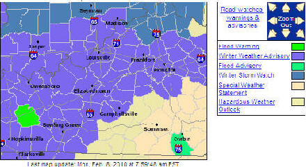
NWS Louisville has issued a Winter Weather Advisory for all of our area... Here's their forecast snow total map:
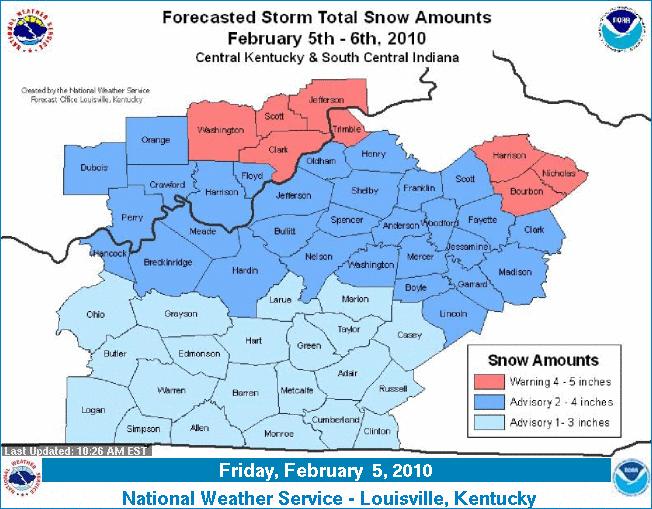
Low pressure will track northeast through eastern Kentucky tonight. The low will drag cold air in from the northwest as it passes to our east and rain will transition to snow from north to south. Snow will begin across the north this evening, while the south can expect snow to begin overnight. The highest amounts are expected over portions of southern Indiana and the Bluegrass where 4 to 5 inches is expected through Saturday. 2 to 4 inches is expected from roughly I-64 south to the Bluegrass Parkway. 1 to 3 inches is expected across south central Kentucky.
Send Snow Totals In !!!
Send weather info and other newsworthy pictures to: 991@scrtc.com or wloc@scrtc.com
Chris Jessie
8am - Friday, February 5th, 2010
Thanks to our good friend, Tammy Sexton from WVLC for the text pic of the Greensburg DQ from this morning on her way to work.
Send weather info and other newsworthy pictures to: 991@scrtc.com or wloc@scrtc.com
Chris Jessie
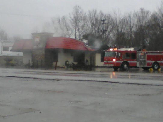
7am - Friday, February 5th, 2010
Got word through our news department this morning that Greensburg Dairy Queen was destroyed by fire last night.... I hate to hear that... great food and good memories of that place. I remember meeting the 92 UK Basketball Seniors ("The Unforgettables") there before they played an exhibition game at Green County High School following their loss to Duke in that epic basketball game in the 92 NCAA Tournament. That's what I remember when I think about the Greensburg DQ, even though I was only 13 at the time.
We've also heard that Waffle House in E-town was damaged by fire. What's up with all this?
Heavy rain for the morning commute... be careful. Lots of ponding on the roads.
Send weather info and other newsworthy pictures to: 991@scrtc.com or wloc@scrtc.com
Chris Jessie
6am - Friday, February 5th, 2010
It's been a few days since I've been able to post, but we've been fairly quiet since early week. I've been reluctant to stick my neck out on this weekend's system. I started with rain, then talk of ice, then back to rain, and now... a rain / snow mix. We are expecting a couple of inches of snow in the northern tier of the area into Saturday morning.
Send weather info and other newsworthy pictures to: 991@scrtc.com or wloc@scrtc.com
Chris Jessie
7:30am - Tuesday, February 2nd, 2010
Taylor County Schools changed from a delay to being closed after reports of Black Ice. A skiff of light showers/freezing rain and snow clipped our region this morning. Not a large impact, though... Temps on the southern half of our area are above freezing. Forecast temps last night were in the mid-upper 20's, but we never did get there. Places that still have ice on the roads... We've had just enough rain on that to make it extra slick... Wet Ice.
On late week: This is a challenge for forecasters. Don't get set on any certain type of precip, yet. It's way too early to say with any degree of certainty about the exact type of precip.
Send weather info and other newsworthy pictures to: 991@scrtc.com or wloc@scrtc.com
Chris Jessie
12:45am - Monday, February 1st, 2010
No Schools Are Reporting, Except Russell County.... Likely to be 4-5pm before decisions are made.
Closings-Cancellations-Delays... Click Here for the 991 Snow Watch Page
Send weather info and other newsworthy pictures to: 991@scrtc.com or wloc@scrtc.com
Chris Jessie
11am - Monday, February 1st, 2010
Whew.... what a weekend of chaos.... I trust everyone made a positive of the weather and at least tried to enjoy the snow. Temps for today have been pushing up and up... we didn't expect above freezing today until early Sunday. But, now looks like we may catch 40.... still difficult to tell with all the snow on the ground. Tomorrow will be even warmer and the melting really takes place into Wednesday.
HEADS UP...
Here is a Jackson/Louisville/Indy NWS discussion for later this week, as we monitor another storm system:
JACKSON W.O.--
THIS
CONTINUES TO BE A SYSTEM WORTHY OF CLOSE ATTENTION GIVEN THE
REGION IS JUST NOW RECOVERING FROM THE SNOWS OF FRIDAY NIGHT AND SATURDAY.
THIS SAME AREA WILL BE UNDER A RENEWED THREAT FOR SIGNIFICANT ACCUMULATING
SNOW UNDER CERTAIN REASONABLE SCENARIOS FOR THE END OF THIS WEEK. IT ALSO
WOULD APPEAR THAT THE NATURE OF ANY SNOW WITH THIS NEXT SYSTEM WILL BE OF A
HEAVIER AND WETTER VARIETY
LOUISVILLE W.O.--
FOR FRIDAY
NIGHT AND THEN THE WEEKEND...EXPECT A CHANGE TO ALL SNOW
AS COLD AIR FILTERS INTO THE REGION. PROBABLY WILL DEAL WITH LIGHT SNOWS
SATURDAY AND SUNDAY AS ADDITIONAL WAVES OF UPPER ENERGY ROTATE ACROSS THE
REGION BEHIND THE MAIN TROUGH.
INDY W.O.--
FOCUS IN
THE EXTENDED REMAINS ON POTENTIAL WINTER STORM TO IMPACT THE OHIO VALLEY FOR
FRIDAY-SATURDAY. AS IS TO BE EXPECTED AT 4-5 DAYS OUT...MODELS ARE PROVIDING
A PLETHORA OF SOLUTIONS. LOW PRESSURE DEVELOPING IN THE WESTERN GULF AS DEEP
UPPER TROUGH EJECTS OUT OF THE INTERMOUNTAIN WEST ON THURSDAY. LOW WILL
TRACK ACROSS THE SOUTHEAST STATES LATE WEEK AND THEN DEEPEN AS IT RIDES UP
THE COAST
SATURDAY. DIFFERENCES COME INTO PLAY WITH RESPECT TO HOW MUCH PHASING OF THE
POLAR AND SUBTROPICAL JETS CAN TAKE PLACE INFUSING THE SYSTEM WITH
ADDITIONAL ENERGY AND POSSIBLY PULLING THE TRACK OF THE LOW WEST TO SOME
DEGREE. THE FASTER THE JETS CAN PHASE (IF THEY PHASE AT ALL) DETERMINES HOW
MUCH MOISTURE CAN GET PULLED WEST INTO
THE OHIO VALLEY AND CONSEQUENTLY WOULD GREATLY INCREASE CHANCES FOR SNOW
FRIDAY AND SATURDAY OVER THE REGION. 00Z GGEM CONTINUES TO BE MOST
AGGRESSIVE IN PHASING THE JET ENERGY WITH ECMWF AND GFS ENSEMBLE MEAN
SOLUTIONS LESS PHASED AND 00Z OP GFS REMAINING LARGELY OUT OF PHASE. AT THIS
POINT...FEEL COMFORTABLE IN MAINTAINING CHANCE POPS FOR FRIDAY AND SATURDAY
WITH ADDITIONAL DETAIL BEING EMPLOYED
THROUGH THE WEEK AS MODELS COME INTO GREATER AGREEMENT
We'll be watching this scenario very closely over the next few days.
Closings-Cancellations-Delays... Click Here for the 991 Snow Watch Page
Send weather info and other newsworthy pictures to: 991@scrtc.com or wloc@scrtc.com
Chris Jessie
5pm - Sunday, January 31st, 2010
Just a heads up... and it's a LONG WAY down the road in forecasting terms, but long range model runs are indicating a similar event for late this upcoming week... Current trend is a bit warmer, but definitely a weather maker. I'm not ready to jump on the bandwagon with this one, yet... but I'm just saying what a couple of the models are agreeing on.
4:30pm - Sunday, January 31st, 2010
School closings are now starting to pour in....
Closings-Cancellations-Delays... Click Here for the 991 Snow Watch Page
7am - Sunday, January 31st, 2010
This winter's 1st major snowfall
dropped totals ranging from 4 to 7 inches of snow across the region this
weekend. It is the largest snowfall in several years. While the local
numbers vary, the official number will go in the book as 5.5 inches of
snowfall for the entire storm. That is the recorded amount from Bowling
Green Regional Airport, which typically is the point of reference for
weather data in our area. The 5.5 total includes 2.8 inches of snow from
Friday and 2.7 on Saturday.
Temperatures will rebound for the first part of the upcoming week, with
conditions just above freezing expected on Monday and near 40 on Tuesday.
Closings-Cancellations-Delays... Click Here for the 991 Snow Watch Page
Send weather info and other newsworthy pictures to: 991@scrtc.com or wloc@scrtc.com
Chris Jessie
10:30am - Saturday, January 30th, 2010
Link: How To Properly Measure Snowfall
Link: Kentucky Road Conditions
10am - Saturday, January 30th, 2010
Enjoy Some Snow Cream !!! My mother, used to make this with half/half, but this looks good, too.
- A gallon of snow
- A cup of sugar
- A Tea Soon Of Vanilla
- Two Cups Of Milk
Mix sugar, milk and vanilla in large bowl... add snow to make desired slush.
I'm seeing some really OVER THE TOP snow totals being e-mailed in to me. Please be sure that when you measure snow, you are away from drift zones... like the south side of your house. The north wind blows over the roofline causing high drift. Get away from structures. Also, measure on a hard surface underneath the snow. If you measure in grass and push a ruler down, you will add depth that actually isn't snow, but rather grass compressed underneath the snow.
Closings-Cancellations-Delays... Click Here for the 991 Snow Watch Page
Send weather info and other newsworthy pictures to: 991@scrtc.com or wloc@scrtc.com
Chris Jessie
8am - Saturday, January 30th, 2010
This seems like old times... haven't had a snow like this in several years. 3.8 at my house. Metcalfe Mesonet has recorded .16 of LIQUID precip since midnight. That is combined with .11 from Friday's total for a .27 storm at this point. With the snow of about 3.8 inches... that's about a 14:1 ratio. Looking at other precip totals, Albany is the highest in our area with .41 so far today and .21 on Friday. Going with the 14:1 formula, that's about 8.8" of snow in Clinton County.
Thanks to Patricia for this pic from Edmonton.
Closings-Cancellations-Delays... Click Here for the 991 Snow Watch Page
Send weather info and other newsworthy pictures to: 991@scrtc.com or wloc@scrtc.com
Chris Jessie
8:50pm - January 29th, 2010
Roads very dangerous... Metcalfe County Judge Executive Greg Wilson says that 911 is receiving very heavy call volume with respect to numerous accidents... If you have an accident with no injuries, please call 670-8813. Let 911 handle the most urgent calls.
I was on I65 in E-town at about 7:30... just a dusting there. Accumulation really starts at about the Glendale area and gets heavier as you come south. The Interstate is at a crawl as you get to about Upton and south.
State/US roads are also becoming very packed.
Don't travel unless you need to.
Right now moderate to heavy snows are coming down in most of the area. I have 2.5 inches at my residence. I am updating from home and keeping up with local information from a variety of sources... a lot is going on, so I'll post as possible.
Closings-Cancellations-Delays... Click Here for the 991 Snow Watch Page
Send weather info and other newsworthy pictures to: 991@scrtc.com or wloc@scrtc.com
Chris Jessie
5pm - Friday, January 29th, 2010
Again, even though many people are asking where is the snow?... NWS is sticking to the guns on total snow amounts. Here is the latest statement from late this afternoon:
Light to
moderate snow started over areas to the east of Interstate 65 by 2 PM CST,
and will continue to cross south-central Kentucky through the remainder of
the afternoon. Occasional snow will continue overnight before diminishing
Saturday morning. Snow amounts of 6 to 10 inches are expected over parts of
south-central Kentucky, including Bowling Green, Glasgow, Columbia, and
Burkesville. Just to the north of this, a band of 5 to 9 inch amounts is
forecast for areas from around Beaver Dam, to Leitchfield, Munfordville,
Campbellsville, Liberty, and Stanford.
A bit farther north over central Kentucky, snow also will develop by late
afternoon and continue tonight before diminishing Saturday. Snowfall amounts
of 3 to 6 inches are likely, with locally higher amounts possible. This
includes cities such as Hardinsburg, Brandenburg, Elizabethtown, Bardstown,
Taylorsville, Danville, Versailles, Lexington, and Richmond.
Areas around Frankfort, Paris, and Cynthiana can look for 2 to 4 inches of
snow Friday night into Saturday morning. For the Louisville Metropolitan
area, and Indiana counties along the Ohio River, snowfall amounts will fall
into the 1 to 3 inch range. Farther north into south central Indiana,
amounts around an inch are expected.
Even though the timing of this
storm was on delay this morning, the duration of the precip tonight will
mount up.
Closings-Cancellations-Delays... Click Here for the 991 Snow Watch Page
Send weather info and other newsworthy pictures to: 991@scrtc.com or wloc@scrtc.com
Chris Jessie
1:30pm - Friday, January 29th, 2010
Starting to see snow showers at studio... Accumulating snow still expected later this afternoon and overnight. Huge snow totals expected for mid-state and eastern Tennessee.
Closings-Cancellations-Delays... Click Here for the 991 Snow Watch Page
KEEP ME INFORMED on your snow totals and conditions. Send a txt message to 270-528-4033, call us on the studio lines... 270-786-4400 or 270-432-7991... or e-mail us... pictures are welcome, too!
Send weather info and other newsworthy pictures to: 991@scrtc.com or wloc@scrtc.com
Chris Jessie
11:30am - Friday, January 29th, 2010
Snow is finding it's way slowly to the Southern Kentucky Region. Cold and dry air at the surface is still holding the snow off. Still expecting significant accumulations... just pushing back a bit. Also the heaviest snow looks to be a little further south with today's track. This is starting to look more like the models from Wednesday, rather than the ones from yesterday.
Down south... big problems in middle Tennessee. Snow and sleet are piling up.
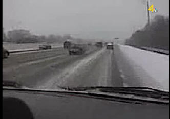
WSMV - Channel 4
I-65 In Nashville
Closings-Cancellations-Delays... Click Here for the 991 Snow Watch Page
Send weather info and other newsworthy pictures to: 991@scrtc.com or wloc@scrtc.com
Chris Jessie
8am - Friday, January 29th, 2010
Lawton Oklahoma... Bad... Lots of ice.
KFOR - Channel 4
Power is out and trees are down. Not a good scene in Oklahoma.
The good part for us is that we DO NOT expect anything like this. We are looking at a snow event.
Closings-Cancellations-Delays... Click Here for the 991 Snow Watch Page
Send weather info and other newsworthy pictures to: 991@scrtc.com or wloc@scrtc.com
Chris Jessie
7am - Friday, January 29th, 2010
Most of the snow that you see on radar at this point is not reaching ground. Dewpoints are still in the lower teens around the area. Metcalfe County's Mesonet site says 13 for the dewpoint and humidity at 71%. So, surface level is not fully saturated. Even in Western Kentucky.....Fulton County's Mesonet is reporting Dewpoint at 16 and humidity at 74%.
Here's the latest winter storm statements from NWS, Louisville:
A storm system will move across Louisiana this afternoon and then into Georgia on Saturday. Well north of this storm, plentiful moisture and cold air will combine to bring a potentially major winter storm to parts of south central Kentucky.
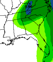
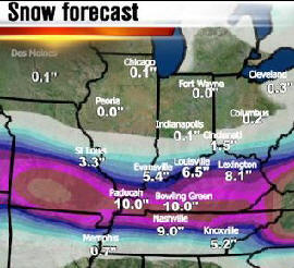
Light to moderate snow should streak across south-central Kentucky starting this afternoon. Occasional snow will continue overnight before diminishing Saturday morning. Snow amounts of 5 to 9 inches are expected over parts of south-central Kentucky, including Bowling Green, Glasgow, Columbia, and Burkesville.
A bit farther north over central Kentucky, snow also will develop by late afternoon and continue tonight before diminishing Saturday. Snowfall amounts of 2 to 5 inches are likely, with locally higher amounts possible. This includes cities such as Leitchfield, Campbellsville, Elizabethtown, Bardstown, Danville, Lexington, and Richmond.
Over north-central Kentucky, including Louisville and Frankfort, 1 to 3 inches of snow is expected, with most of the snow occurring Friday night and Saturday morning. Over south-central Indiana, around 1 inch is possible.
There is still some uncertainty as to the track of this storm. A northward shift could bring higher amounts farther north in central Kentucky, and a more southern track would limit snowfall amounts over southern Indiana and north-central Kentucky. A stronger storm also could increase snow amounts across the area. Citizens should stay tuned to the latest forecast updates on this winter storm.
I will post several times today,
but will probably be very short and to the point.
Closings-Cancellations-Delays... Click Here for the 991 Snow Watch Page
Send weather info and other newsworthy pictures to: 991@scrtc.com or wloc@scrtc.com
Chris Jessie
6:30pm - Thursday, January 28th, 2010
Most area schools are closing for Friday.
Closings-Cancellations-Delays... Click Here for the 991 Snow Watch Page
6pm - Thursday, January 28th, 2010
*** Start of snow now advanced from last estimates ***
Just consulted with a couple of local school systems about likelihood of calling off classes for Friday. There is some hesitating to do so at this time based on today's earlier statements from the NWS that snows might hold off into the afternoon hours. This would allow schools to get in a partial day. However, a new statement from the Louisville office offers the following information:
Moisture riding over the top of this system will generate light to moderate snowfall starting early Friday morning and continuing into Saturday across our region. The heaviest snows likely will fall in the period from 9 AM Friday morning to 10 PM Friday evening, with snow beginning as early as 5 AM Friday across south-central Kentucky.
Light to moderate snow should streak across south-central Kentucky starting Friday morning, with snow heavy at times Friday afternoon and Friday night before diminishing Saturday morning. Snow amounts of 5 to 9 inches are expected over parts of south-central Kentucky, including Bowling Green, Glasgow, Columbia, and Burkesville. Isolated higher amounts are possible.
I'll be posting any school info as soon as I receive it. Some schools (especially in western portions of our area) may decide this evening to call off school.
Closings-Cancellations-Delays... Click Here for the 991 Snow Watch Page
Send weather info and other newsworthy pictures to: 991@scrtc.com or wloc@scrtc.com
Chris Jessie
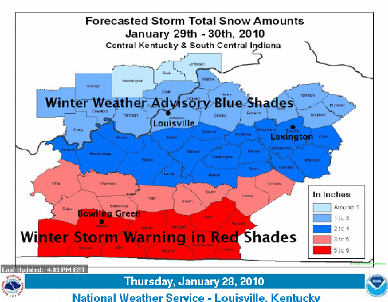
3:30pm - Thursday, January 28th, 2010
New Forecast Package is out..... snow totals estimates are increased and the storm track projection is shifted to the north just a bit. The Winter Storm Warning is now including Hart, Green, Taylor, Grayson and Edmonson. Areas from there north to Louisville have been placed on a Winter Storm Watch.
Check out Belski's map for snow totals... we're right in his sweet spot.
WAVE 3 - John Belski's Snow Forecast...
Click Map To Goto His Discussion Pate
NWS still slightly more conservative:
There is a lot to take in from the new model runs. I'll be posting more later. I've been in contact with some schools. Many of the school systems are collaborating among themselves about Friday Classes. Timing on the snow arrival and subsequent accumulation is still not nailed down on this. Still a lot of variance on this point.
Send weather info and other newsworthy pictures to: 991@scrtc.com or wloc@scrtc.com
Chris Jessie
10am - Thursday, January 28th, 2010
NWS Conference Call from this morning.... Key points:
* Timing is push back on the arrival of snow. Likely to be a Mid-Late Friday event for our Northern area, with earlier timing for Southern Counties (Near KY-TN Border).
* Total storm event is expected to be longer with moderate snow rather than shorter snows with heavy bursts. Expecting a 24-hour type event. Looking at the length of time rather than the intensity for the creation of accumulation.
* Likely an extension for the Winter Storm Warning for South Kentucky into Saturday evening rather than expiring on Saturday.
* Likely to see addition/upgrade to Winter Strom Warning for Edmonson, Grayson, Hart, Hardin, LaRue, Green Taylor and Casey County areas for later today.
* Friday morning commute will likely be OK. Snow to the west and south first.... afternoon drive still in question.
* New Forecast Package set to be released around 3pm Central today. Models are trending slightly north movement on track. However, lower level moisture saturation may "eat up" initial snow fall.
Those are the key points for our particular area. We must keep in mind that the snow accumulation totals are spread out over the entire event. We are not expecting a wave of Snow Band situations. But, we are expecting a more drawn out accumulation. This is good news for travel, because the road prep has a better chance of being effective. Also, traffic on the roads can help provide resistance to surface accumulation.
We can expect a wet type snow locally, with drier / more fine snow to the north. The wetter snow will make for slushy driving conditions.
Temps will be below freezing until at least Monday... depending on the snow cover, maybe even into Tuesday. And, following that, another system is lined up... Too far out to tell at this point, but maybe a snow/rain event mid next week.
Send weather info and other newsworthy pictures to: 991@scrtc.com or wloc@scrtc.com
Chris Jessie
6am - Thursday, January 28th, 2010
New info from Louisville NWS... Winter Storm Warning for Warren, Barren, Metcalfe, Adair and all Counties SOUTH of that line down to the Tennessee Border.
...WINTER STORM WARNING IN EFFECT
FROM 6 AM FRIDAY TO 6 AM CST
SATURDAY...
THE NATIONAL WEATHER SERVICE IN LOUISVILLE HAS ISSUED A WINTER
STORM WARNING FOR SOUTH CENTRAL KENTUCKY NEAR THE TENNESSEE
BORDER. THIS IS IN EFFECT FROM 6 AM FRIDAY TO 6 AM CST SATURDAY. THE
WINTER STORM WATCH IS NO LONGER IN EFFECT.
* SNOW WILL BEGIN ACROSS FAR SOUTH CENTRAL KENTUCKY FRIDAY
MORNING. SNOWFALL WILL LIKELY CONTINUE THROUGH EARLY SATURDAY
MORNING.
* ACCUMULATIONS THROUGH THIS TIME PERIOD ARE EXPECTED TO BE 4 TO 7
INCHES SOUTH OF A LINE FROM MORGANTOWN IN BUTLER COUNTY...TO
COLUMBIA IN ADAIR COUNTY.
* PERIODS OF HEAVY SNOW AND REDUCED VISIBILITIES COULD CAUSE
TRAVEL PROBLEMS ACROSS THE WATCH AREA FRIDAY INTO SATURDAY.
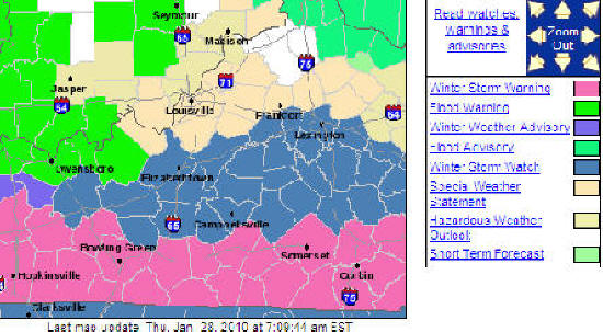
Here's an updated accumulation forecast map from NWS - Louisville...

Send weather info and other newsworthy pictures to: 991@scrtc.com or wloc@scrtc.com
Chris Jessie
2pm - Wednesday, January 27th, 2010
NWS conference call just wrapped.... Winter Storm Watch coming out for portions of our area... mainly south of E-town.
Northern TN is now in Winter Storm Watch.
See the Nashville NWS office page here...
Send weather info and other newsworthy pictures to: 991@scrtc.com or wloc@scrtc.com
Chris Jessie
1pm - Wednesday, January 27th, 2010
A great Web Chat is going on with Chris and Shane of WBKO right now.
Here's the link:
http://www.wbko.com/stormstream
I always respect Chris Allen and Shane Holinde for their genuine concern for safety in our region of Kentucky. That is a mark of great broadcaster... being able to be a professional and an still be a person that is real and compassionate.
The latest on the storm... see below.... not much changed since this morning as the forecast goes. The GSM / NAM models are in agreement for the first 12-18... but then start to vary on the run as we go 24-48-72 and later.
We'll post again later.
Send weather info and other newsworthy pictures to: 991@scrtc.com or wloc@scrtc.com
Chris Jessie
7am - Wednesday, January 27th, 2010...
I appreciate all the e-mail questions... thanks for letting me know you're following my page. I've been working out of the studio a lot for the past several days, so it's been hard to post.
Also, thanks for the recommendation to enlarge the time/post header. I totally understand what you were saying about not being able to easily see the font/size/color on some screens.
I'll be updating regularly through now thru the weekend's storm system.
A Winter Storm Watch is posted for Western Kentucky.
NWS Statement:
A storm system is expected to develop across Texas Thursday and move across the Deep South Friday and Friday night. Moisture riding over the top of this system will generate light to moderate snowfall starting early Friday morning and continuing into Saturday across our region. The heaviest snows likely will fall in the period from 9 AM Friday morning to 10 PM Friday evening, with snow beginning as early as 5 AM Friday across south-central Kentucky. The latest forecast calls for snow totals of up a half a foot possible across parts of far South-Central Kentucky and the Lake Cumberland areas. Further north across the Louisville/Lexington corridor, totals around 1-3 inches are possible.
There is still large uncertainty in the exact track of the storm system moving by to our south. A more southern track would mean less snowfall from the amounts given above. Residents of and visitors to the region should stay tuned to the latest forecast updates on this developing winter storm.
Here's the latest snow estimate graphic for FRIDAY from the NWS Louisville office.
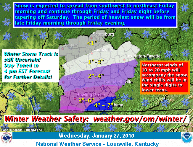
There is still a lot of disagreement among various forecasters... NWS, AccuWeather, Weather Channel... The track continues to trend south in both the GFS and NAM runs. A more consistent estimate/consensus should be out for this afternoon.
Send weather info and other newsworthy pictures to: 991@scrtc.com or wloc@scrtc.com
Chris Jessie
Friday, January 15th, 2010.....7am
Only in Kentucky.... right? From 10-15 below normal to about 10-15 above normal, a week is swinging about a 25 difference.
Rain this weekend... Saturday night, rain may be heavy at times. To our north, still some discussion about minor icing if moisture is present that far, although most of the moisture from this system is to our south and will push up through Eastern Kentucky and out to the coast. Night lows are only expected in the mid/upper 30's for So.Ky.
Beginning of next week is warm, too. Temps look to push into the lower 50's on Mon/Tue with another system moving through mid/late week... looks like rain at this point.
Next cold pattern looks to push in around the last week of the Month and perhaps an artic blast after that for the first week of February. This is based on previous patterns and not necessarily "map/model logic".
Send weather info and other newsworthy pictures to: 991@scrtc.com or wloc@scrtc.com
Chris Jessie
Wednesday, January 13th, 2010..... 10am
A little colder than forecast allowed for last night. Forecast lows expected about 22. Temps were in the lower 10's around the region. BG recorded 15 around 6am. State's low happened in Richmond with 6. Fog in some areas this morning caused some icing in Northern/Western parts of the Commonwealth.
Temps are shooting up quite nicely, and will continue though for the afternoon. Expect around 40 for the high. Lots of melting should take place with the sunshine. Expect near 50 on Friday.
Model runs are still inconsistent for this weekend's Southern US system. I'm still not expecting a lot of rain, but showers are possible Sat/Sun and at night a winter mix may factor in at times. Temps are trending warmer, with overnight lows (at least for now) not expected to fall below freezing.... still going to stay shy on the precip/type forecast.
Big story yesterday and today is Haiti's big 7+ earthquake. I really don't like how the media spins the numbers... If you'll notice all the headlines say 3+ Million people affected by quake... What does that actually mean? The death toll isn't high enough or the injured number isn't high enough?... So, let's use the 3 Million number cause it's more impressive?... On the science side of it, at least 35 aftershocks have hit since the main quake and many structures have collapsed. Estimating the deaths/injuries/cost of the quake is not realistically possible at this time, regardless of the exaggerated news reports. This area has fallen on hard times from the natural disaster standpoint over recent years. Several hurricanes struck in the previous year or so, where assessments say that around 22,000 homes were destroyed and agricultural producers lost around 70% of their crops.
Closings-Cancellations-Delays... Click Here for the 991 Snow Watch Page
Send weather info and other newsworthy pictures to: 991@scrtc.com or wloc@scrtc.com
Chris Jessie
Tuesday, January 12th, 2010...4pm
Haven't had much time today to write... playing catch-up from all the fun of the last few days. Temps today were reported at 31-32 in parts of the region. Mostly below freezing, though, for just about everybody.
The real thaw out begins Wednesday. And, by Friday we'll flirt with 50. Ground should be really nice and soupy for all the hard working farmers and hay feeders.
Late Saturday, we'll put some rain on top of that. Looks like maybe some mixed precip for Saturday night and Sunday night as night-time lows go to or slightly below freezing. Most of the models agree on temp but are still tugging over the anticipated storm track. We're still watching this one, but not really expecting anything of great magnitude.
Schools should be in pretty good shape for just about everybody on Wednesday. I think we'll see mostly delays if anything. Get the true story on the closings page.
Closings-Cancellations-Delays... Click Here for the 991 Snow Watch Page
Send snow totals, weather info and other newsworthy pictures to: 991@scrtc.com
Chris Jessie
Monday January 11th, 2010...10am
Snow showers this morning provided an additional dusting for much of the area. Tonight's dusting could cause some driving problems for Tuesday morning's commute... Especially for North/Eastern parts of the area.
Watching the late week storm for winter weather potential. Looks like most precip will be to our South. North side of low could get a winter mix on Friday night as lows flirt with the freezing mark. Icing has been hinted in the models for Northern Tennessee and Southern Kentucky. Still a lot more to go on seeing how this one plays out for the upcoming weekend.
Today's temps and Tuesday's temps have been amended down, but the thaw will still happen by Wednesday with highs into the 40s and near 50 by Thursday and Friday before the next frontal passage.
No word yet, on any schools. I expect that with the possibility of snow showers tonight, we won't get any announcements until early Tuesday morning.
Closings-Cancellations-Delays... Click Here for the 991 Snow Watch Page
Send snow totals, weather info and other newsworthy pictures to: 991@scrtc.com
Chris Jessie
Sunday January 10th, 2010...4pm
New school closings.... see the 991 Snow Watch page for details.
Closings-Cancellations-Delays... Click Here for the 991 Snow Watch Page
Send snow totals, weather info and other newsworthy pictures to: 991@scrtc.com
Chris Jessie
Sunday, January 10th, 2010.....2pm
Cold overnight readings... Bowling Green recorded 10 above... but there were plenty of colder readings from around.... With a good snow pack on ground, Henderson recorded the state's lowest temp at -2. Owensboro dropped to 1 above, while Paducah and London each recorded 3 above. The station observation recorded 7 above for the overnight low.
Solar surface warming has melted most roadway snow and ice, except for those areas where the roads are shaded from the sun. Many of the "back roads" are still slick in spots and the melting will re-freeze overnight.
Monday night, we could see another light accumulation. We'll see how that works out. The higher likelihood of snow is north and east of our region.
A Warm up still coming for mid-week. Another system moves in for Thursday/Friday. Here's a new scary outlook.... at least one model run is showing ice for our area at this point.
Schools still haven't announced any closures at this point for Monday classes. Keep checking on the closings/cancellation page.
Closings-Cancellations-Delays... Click Here for the 991 Snow Watch Page
Send snow totals, weather info and other newsworthy pictures to: 991@scrtc.com
Chris Jessie
Saturday, January 9th, 2010.....1pm
About an additional inch of fluffy snow overnight for most of the area.... Primary roads are in good shape. However, the secondary roads are still packed and very slick in places. Cold tonight. Forecast says 10... and again I still say a bit colder... maybe even 5 or below because of the snow cover. We'll see what the lows are from the Mesonet readings for Sunday morning.
May get a skiff of snow on Monday night. Not looking like anything major.
Thaw out is coming by about Tuesday.... we should be into the 40's by mid week and another system will bring precip by late week... PM Thursday into Friday. Looks like a mainly rain event at this point.
Closings-Cancellations-Delays... Click Here for the 991 Snow Watch Page
Send snow totals, weather info and other newsworthy pictures to: 991@scrtc.com
Chris Jessie
Friday, January 8th, 2010..... 1pm
Congrats on our snow total guess winner, Joe Huer. He guessed 1.5" as Thursday's total, which officially came in at 1.4". Joe wins a 991 Snow Day Prize Package, featuring an Elvis 75 Anniversary Collection (Today is Elvis' Birthday) along with DVD's and some other snow day goodies. Thanks to all who entered the contest. Maybe we'll get enough snow to do it again in the next couple of weeks.
I still believe Saturday night's low will be closer to Zero than 10, which is the current forecast low.
Closings-Cancellations-Delays... Click Here for the 991 Snow Watch Page
Send snow totals, weather info and other newsworthy pictures to: 991@scrtc.com
Chris Jessie
Friday, January 8th, 2010..... 7am
Brrrr.... Cold morning... Slick roads... Lots of accident's reported with one fatality in Barren County from Thursday afternoon. Park roads are closed through mid-morning in Mammoth Cave National Park. A few snow showers can be expected today and tonight, but no significant accumulations.
Thursday snow totals from around the state:
2.7" LEXINGTON (OFFICIAL)
2.9" LOUISVILLE INTERNATIONAL (OFFICIAL)
1.4" BOWLING GREEN (OFFICIAL)
We'll announce our snow guessing On-Air contest winner just after 8am on The Trader.
It's cold and going to get colder. Some good news is that so far, winds haven't been up to the forecast levels. That's helped to make it a little more bearable.
If you're a snow lover, this weeks system may be a bit of a disappointment. The Forecast slightly exaggerated the accumulation. Looking ahead to next week.... a system should arrive by late week, but right now looks like a rainer.
Remember this date?... I sure do... Unless you had steel spikes on your tires, you weren't going anywhere... January 8th, 1999 -- A mixture of snow, sleet, and freezing rain broke out across central Kentucky late on January 7 and then changed mainly to a mix of freezing rain and sleet during the morning of January 8. At one point over 100 tractor trailer rigs were stranded on the Western Kentucky Parkway between Caneyville and Leitchfield. In Hart County a state of emergency was declared that barred all travel on area roads, after 80 to 100 vehicles became stranded.
Closings-Cancellations-Delays... Click Here for the 991 Snow Watch Page
Send snow totals, weather info and other newsworthy pictures to: 991@scrtc.com
Chris Jessie
Thursday, January 7th, 2010.....6pm
Temps are really dropping and roads are icing over. No more slush... be careful. Most local estimates are around 1.25" to around 3" in our Northern coverage area. Winds will pick up tonight and we'll see blowing snow and lingering snow showers tonight and tomorrow may create a small acumulation on top of what we already have.
We'll be watching the Satuday clearning, as we could see temps trent even colder for overnight lows. Still thinking 0 is possible with the snow amounts to the North.
Long day... we'll see ya in the morning. Want your snow totals!!!!!
KEEP ME INFORMED on your snow totals and conditions. Send a txt message to 270-528-4033, call us on the studio lines... 270-786-4400 or 270-432-7991... or e-mail us... pictures are welcome, too!
Closings-Cancellations-Delays... Click Here for the 991 Snow Watch Page
+
Send snow totals, weather info and other newsworthy pictures to: 991@scrtc.com
Chris Jessie
Thursday, January 7th, 2010.....1pm
NWS has issued a special statement for our area about tonight's wind conditions:
THE LIGHT SNOW WE HAVE BEEN SEEING TODAY WILL BE TAPERING OFF TO FLURRIES AND SCATTERED SNOW SHOWERS BY LATE AFTERNOON. AS THE SNOW ENDS A COLD FRONT WILL USHER IN WEST WINDS OF 15 TO 25 MPH WITH HIGHER GUSTS. THESE WINDS WILL CAUSE SIGNIFICANT BLOWING AND DRIFTING SNOW...ESPECIALLY IN RURAL AREAS.
Thursday, January 7th, 2010.....11am
A wintry mix of snow, sleet and some rain is being reported in our area. While out on around town just a few minutes ago, I experienced lots of sleet pellets hitting the windshield. The sleet and rain are draining the accumulation potential for snow. One more large area of precipitation is off to the west pushing our direction. If it remains all snow, we can see a little more accumulation.
Heavier banding of snow now occurring in Louisville/Floyds Knobs area up to the north. If some banding takes place down state with inflow moisture, we may also experience some brief bursts of snow later today.
Right now, 3/4" in the parking lot here.
Thursday, January 7th, 2010.....7:30am
System is not putting down the large snow totals expected off to our west. St. Louis is about 2 inches under the 5 inches expected there.
Currently 1/2 inch snow at our Studio. I'm guessing another 1/2 inch with the mid-day burst that will move through... added to what we have and an additional 1/2 inch of daytime light snow shower activity will put us up to the 1.5" total for today.
Still thinking we a few snow showers later tonight for a 1/2 inch or so.
KEEP ME INFORMED on your snow totals and conditions. Send a txt message to 270-528-4033, call us on the studio lines... 270-786-4400 or 270-432-7991... or e-mail us... pictures are welcome, too!
Closings-Cancellations-Delays... Click Here for the 991 Snow Watch Page
Send snow totals, weather info and other newsworthy pictures to: 991@scrtc.com
Chris Jessie
Thursday, January 7th, 2010.....5:30am
Heavy snow pocket pushing east along the WK Parkway from Leitchfield to Elizabethtown. It will likely continue to push along the Bluegrass Parkway corridor east of E-Town. Plenty of new snow pockets popping up to our west and moving this way.
Thursday, January 7th, 2010.....5:30am
Light snow showers now starting along the I-65 areas.
Thursday, January 7th, 2010.....5am
Most all schools in the area are now out for today. Snow is advancing east. Last night, early snow showers developed and moved as far as Hopkinsville by about 7-8pm. That initial "line of lift" set of the snow showers that dissipated as they moved east. The bulk of the moisture (which on a national radar view is quite impressive) is moving through Southern Illinois and Western Kentucky here in the pre-dawn hour. A heavy batch of snow is now falling between Bowling Green and Owensboro.
Still looking at 1-3 inches for today...(North to South gradient... 1 in Southern Kentucky and up to 3 in the Bluegrass Parkway corridor). Just as I have since the beginning of this system, I'm favoring the lower end of that scale. We'll still have to wait and see.
On a hopeful note for those wanting to see a large accumulation total: If some southerly moisture could somehow get pulled up into this, we may see some trailing bands of snow that pile up on us. The problem with that scenario is that the Low associated with all of this is pretty far north. Not likely, though... just a hopeful thought.
KEEP ME INFORMED on your snow totals and conditions. Send a txt message to 270-528-4033, call us on the studio lines... 270-786-4400 or 270-432-7991... or e-mail us... pictures are welcome, too!
Closings-Cancellations-Delays... Click Here for the 991 Snow Watch Page
Send snow totals, weather info and other newsworthy pictures to: 991@scrtc.com
Chris Jessie
Wednesday, January 6th, 2010...10pm
Snow is already into Western Kentucky. Precip is moving west slightly ahead of forecast timeframe. More schools are now added to the closings list.
Closings-Cancellations-Delays... Click Here for the 991 Snow Watch Page
Send snow totals, weather info and other newsworthy pictures to: 991@scrtc.com
Chris Jessie
Wednesday, January 6th, 2010.... 6pm
As we mentioned earlier, most area schools are still waiting to see tonight's final forecast. However... Hart, Green, Caverna and Taylor have already cancelled Thursday classes. I expect to hear an update from Metcalfe County 7-8pm. No word on Barren/Glasgow, Monroe, Cumberland or Adair.
Also, as expected, the National Weather Service has issued the Winter Storm Warning for upper portions of our listening area and a Winter Weather Advisory for the rest of us.
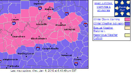
I'll be in early (2-3am) to update Thursday morning. We should have a radar intercept for snow off to our West at that point.
Closings-Cancellations-Delays... Click Here for the 991 Snow Watch Page
Send snow totals, weather info and other newsworthy pictures to: 991@scrtc.com
Chris Jessie
Wednesday, January 6th, 2010....2pm
No changes to report in the forecast (see previous post below).
I have talked with a couple of school officials about the possibility of cancellations. What I've been told by both is that they are going to take a wait and see attitude about Thursday. If the forecast intensifies by tonight there may be a call made. If not, they will make decisions on Thursday morning. The forecast moisture has gradually gone from 4-6" snowcast back on Monday to 3-4" yesterday and now 1-3" the call today. So, they will see if there is a trend down again.
Keep checking back.
I'd love to hear your snow sledding stories or fun stories that happened during winter storms of the past. On the air this morning, I recalled my 1996 Senior High School year and getting stuck at a friends house during that whopping 16" snow. Pictures are welcome, too.
I'll keep posting throughout the day.
Closings-Cancellations-Delays... Click Here for the 991 Snow Watch Page
Send snow totals, weather info and other newsworthy pictures to: 991@scrtc.com
Chris Jessie
Wednesday, January 6th, 2010....10am
New runs are indicating a slightly later push for the snow. Likely I-65 area will be experiencing snow by or just after day break. East of I-65 should be well after day-break before snow fall.
Snow will not be a heavy/wet snow. It will be a light and fluffy type event. Areas with high traffic volume will help to simply wisp away the snow powder. Packing may take place but pre-treatment that causes melting may actually allow the snow to "stick" to the road rather than it just blowing off. Several of our area roads were pre-treaded on Tuesday. Due to the fact that there is no pre-snow rain to wash that off, the liquid treatment has already "bonded" to the road surface.
Local Schools have a tough call for Thursday. I am still favoring a lower snow total. But, the bulk of the snow that we get will mount up during the mid/morning hours and taper off by mid-day. The forecast still has 1-3 inches for areas in the areas to the South the Bluegrass Parkway corridor. A total of 3-5 inches expected to the North of that line.
New Winter Storm Warning expected for northern counties. A Winter Weather Advisory expected for the rest of us and down to the Tennessee state line. We'll post that info after it is issued.
Winds will likely pick up later in the day and into Thursday night. Westerly breezes 15-20mph will continue into Friday with higher gusts possible. Blowing snow and drifting will be an issue in areas that get significant accumulations.
This should be a fairly even snow. The gradient of totals will likely be even... more north and less south.
Additional snow on Thursday night from back side moisture will be at a higher liquid/snow ratio.... closer to 20-25:1 With that in mind, it won't take a lot to mount up, but 1/2" to 1" not out of the question, especially to the north.
COLDER temps Friday night and Saturday. Friday night temps will be likely in the upper single digits. If clearing occurs early enough on Saturday night... and IF we have a considerable snow pack, temps could easily get to zero or below, contrary to what the forecast lows are at this point.
I'll keep posting throughout the day.
Send snow totals, weather info and other newsworthy pictures to: 991@scrtc.com
Chris Jessie
Wednesday, January 6th, 2010...9:30am
I'm on conference call now with National Weather Service. We'll report on the info in just a bit. New Winter Storm Warning expected for northern counties. A Winter Weather Advisory expected for the rest of us and down to the Tennessee state line. We'll post that info after it is issued.
I'll be posting more later.
Send snow totals, weather info and other newsworthy pictures to: 991@scrtc.com
Chris Jessie
Wednesday, January 6th, 2010....7am
Winter Storm Watch late tonight through Thursday Afternoon... Owensboro and areas just to the West of that are under a Winter Storm Warning. (NWS Map)
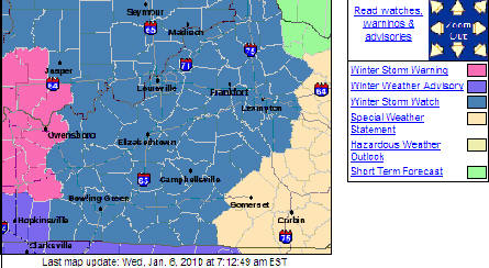
We're about 24-hours out from the beginning of precip here in Southern / Central Kentucky. There is still a variety of forecast estimates as to how much snow will accumulate. NWS now says "around 2 inches" through Thursday for our region of the state with another 1/2 inch possible on Friday as the wrap around moisture allows for snow shower activity. Here's what WAVE-3's John Belski says (map linked to John's weather discussion page at www.wave3.com):
I'm still not sold on even that much snow. I still believe the system will pick up speed and the precip won't be as prolonged as the current forecast stands. We'll have to see. One good thing is that the winds may not be as gusty as first expected. Although it should be a breezy day on Thursday, the 30mph gusts don't look as likely now. I'm still going with the 1-2 inch estimate with maybe another inch on Friday.
Typical snow/rain ratio conversion is about 10:1 as the precip model maps only estimate moisture in liquid form. So, part of the winter weather forecasting "formula" for getting it right is adapting the correct ratio. That involves several variables. With this storm, some forecasters are saying 20+:1 ratios. The Artic air mass attributes to the high ratios. Basic translation is that the higher the snow to rain ratio is, less moisture creates higher accumulation totals.
I'll be posting more later.
Send snow totals, weather info and other newsworthy pictures to: 991@scrtc.com
Chris Jessie
Tuesday, January 6th, 2010.....2pm
A Winter Storm Watch is now in effect for our entire listening area.
...WINTER STORM WATCH IN EFFECT FROM LATE WEDNESDAY
NIGHT THROUGH
THURSDAY AFTERNOON...
THE NATIONAL WEATHER SERVICE IN LOUISVILLE HAS ISSUED A WINTER
STORM WATCH...WHICH IS IN EFFECT FROM LATE WEDNESDAY NIGHT
THROUGH THURSDAY AFTERNOON.
A STORM WILL SPREAD SNOW ACROSS ALL OF SOUTHERN INDIANA AND
CENTRAL KENTUCKY BEGINNING EARLY THURSDAY AND CONTINUING THROUGH
THE AFTERNOON HOURS.
* TIMING...SNOW WILL BEGIN DURING THE PRE-DAWN HOURS THURSDAY WEST OF
INTERSTATE 65 AND OVERSPREAD THE BLUEGRASS AND LAKE CUMBERLAND
AREAS SHORTLY AFTER DAWN. SNOW WILL END BY MID TO LATE AFTERNOON
ACROSS CENTRAL KENTUCKY. HOWEVER...LIGHT SNOW MAY LINGER THROUGH
THE EVENING HOURS ACROSS SOUTHERN INDIANA.
* MAIN IMPACT: TOTAL SNOWFALL AMOUNTS OF 3 TO 5 INCHES ARE
POSSIBLE ACROSS NORTH CENTRAL KENTUCKY AND SOUTHERN INDIANA.
SNOWFALL AMOUNTS NEAR THE TENNESSEE BORDER MAY BE SLIGHTLY LESS.
WITH TEMPERATURES REMAINING WELL BELOW FREEZING...THIS SNOW WILL
READILY STICK. EXPECT DETERIORATING ROAD CONDITIONS AND
DIFFICULT TRAVEL THURSDAY MORNING.
* OTHER IMPACTS: VERY COLD ARCTIC AIR WILL ARRIVE BY EARLY EVENING
THURSDAY. NORTHWEST WINDS UP TO 15 MPH WILL BRING BLOWING AND
DRIFTING SNOW THAT MAY REDUCE VISIBILITIES. WIND CHILL READINGS
WILL LIKELY FALL TO BETWEEN 0 AND 10 ABOVE DURING THE EVENING
HOURS.
Send snow totals, weather info and other newsworthy pictures to: 991@scrtc.com
Chris Jessie
Tuesday, January 5th, 2010...8am
Here we go.... fist snow? I'm still going to wait until this afternoon's models before putting my own accumulation guestimate on here. Here's the latest advisory from the NWS Louisville office....
...FIRST SIGNIFICANT SNOWS OF THIS WINTER SEASON AND
BITTERLY COLD
CONDITIONS TO AFFECT THE REGION LATER THIS WEEK...
THE LATEST WEATHER FORECASTS ARE COMING IN TO VERY GOOD AGREEMENT
WITH A STORM SYSTEM BRINGING THE FIRST SIGNIFICANT SNOWFALL TO THE
REGION. THIS STORM SYSTEM WILL BEGIN TO AFFECT THE WESTERN
SECTIONS OF KENTUCKY LATE WEDNESDAY NIGHT AND EARLY THURSDAY
MORNING. SNOWS WILL SPREAD EAST ACROSS SOUTH CENTRAL INDIANA AND
CENTRAL KENTUCKY DURING THE DAY ON THURSDAY AND BEGIN TO DIMINISH
IN INTENSITY LATE THURSDAY NIGHT. BASED ON THE LATEST
WEATHER DATA...SNOWFALL ACCUMULATIONS OF AROUND 4 INCHES ARE EXPECTED
ACROSS THE ENTIRE AREA. SOME HIGHER AMOUNTS OF SNOWFALL ARE LIKELY
DURING THIS TIME PERIOD. IF LATER FORECASTS CONTINUE TO BE IN
AGREEMENT WITH THE LATEST TRENDS...A WINTER STORM WATCH MAY BE
ISSUED LATER TODAY.
THE IMPACTS ASSOCIATED WITH THIS SYSTEM ARE LIKELY TO BE SIGNIFICANT
ACROSS SOUTHERN INDIANA AND CENTRAL KENTUCKY. WITH AN ANTECEDENT
ARCTIC AIRMASS IN PLACE...SNOW FALLING DURING THE DAY THURSDAY
WILL ACCUMULATE AREA ROADWAYS AND MAKE TRAVEL CONDITIONS ACROSS
THE AREA VERY HAZARDOUS. IN ADDITION...STRONG GUSTY WINDS ARE
EXPECTED TO ACCOMPANY THE SYSTEM AS IT MOVES THROUGH. SUSTAINED
WINDS OF 15 TO 20 MPH WITH GUSTS AS HIGH AS 30 MPH WILL RESULT IN
THE BLOWING AND DRIFTING OF SNOW. THE BLOWING SNOW WILL RESULT IN
DECREASED VISIBILITIES AT TIMES. THE COMBINATION OF COLD
TEMPERATURES AND THE WIND WILL ALSO DRIVE WIND CHILL READINGS DOWN
TO NEAR ZERO.
AS THE STORM SYSTEM MOVES OFF TO THE EAST ON FRIDAY...A RE-
ENFORCING SHOT OF ARCTIC AIR WILL PUSH INTO THE REGION. ALONG WITH
THE COLDER TEMPERATURES...SNOW SHOWERS AND SNOW SQUALLS WILL BE
COMMONPLACE AND SOME ADDITIONAL LIGHT SNOW ACCUMULATIONS WILL BE
POSSIBLE. WITH THE ANTICIPATED SNOWFALL ACCUMULATIONS...THIS COLD
SHOT OF AIR WILL RESULT IN TEMPERATURES DROPPING INTO THE LOWER
SINGLE DIGITS FRIDAY NIGHT AND POSSIBLY BELOW ZERO SATURDAY
NIGHT AND SUNDAY NIGHT.
NOW IS THE TIME TO START MAKING PREPARATIONS FOR THE UPCOMING SNOW
AND COLD. MAKE SURE YOU HAVE TAKEN STEPS TO PROPERLY WINTERIZE
YOUR CAR. AREA ROADWAYS ARE LIKELY TO BE HAZARDOUS THURSDAY AND
THURSDAY NIGHT. BE SURE TO GIVE YOURSELF PLENTY OF SPACE OUT ON
THE ROADWAY AND ALLOW EXTRA DISTANCE TO STOP. ALSO MAKE SURE YOU
GIVE YOURSELF PLENTY OF TIME TO REACH YOUR DESTINATION.
IN YOUR HOME...TAKE PRECAUTIONS TO WINTERIZE ANY EXPOSED
WATER PIPES TO KEEP THEM FROM FREEZING. BE SURE USE CAUTION WITH
SPACE HEATERS IN YOUR HOME AND KEEP THEM AT LEAST 3 FEET AWAY FROM
FLAMMABLE OBJECTS SUCH AS CURTAINS AND FURNITURE. NEVER USE A GAS
STOVE OR CHARCOAL GRILL TO HEAT YOUR HOME. THESE DEVICES RELEASE
CARBON MONOXIDE WHICH IS ODORLESS AND CAN KILL.
BE SURE TO CHECK ON THE WELL BEING OF THOSE THAT MAY SUFFER MORE
FROM THE EFFECTS OF THE COLD...ESPECIALLY THE ELDERLY AND YOUNG
CHILDREN. IF YOU HAVE TO WORK OUTSIDE...BE SURE TO DRESS IN LAYERS
AND COVER YOUR HEAD...EARS AND HANDS. MOST BODY HEAT IS LOST
THROUGH THE HEAD THAN MOST PEOPLE REALIZE. TAKE IT EASY OUTDOORS.
EXTREME COLD PUTS EXTRA STRESS ON THE BODY.
AREA FARMERS AND PRODUCERS ARE URGED TO TAKE PRECAUTIONS TO ENSURE
LIVESTOCK CAN HANDLE THE BITTERLY COLD WEATHER CONDITIONS. ENSURE
THAT LIVESTOCK HAVE UNFROZEN WATER AND WIND BREAKS OR SHELTER AND
EXTRA FEED. HOUSEHOLD PETS IF KEPT OUTSIDE SHOULD BE BROUGHT IN IF
POSSIBLE.
Send weather and other newsworthy pictures to: 991@scrtc.com
Chris Jessie
Monday, January 4th, 2010... 6am
Happy New Year...! As you wake up this morning, you'll find a dusting of snow across the area.
Cold will hang on for this week. Also, there is good possibility of accumulating show mid/late week. There are still some questions as to where the storm track will pass. I've been pro-snow on my outlook for the last two major systems and gotten "melted" by the warmer flow. So... with this one, I'm going to be more cautious... even though most models are in agreement that an accumulating snow will occur here during that time frame.
Forecast should really solidify midday/late Tuesday for the snow potential. I'm not going to get too excited, yet. There is still some question as to how much moisture will be available for a significant snow. We'll see.
Send weather and other newsworthy pictures to: 991@scrtc.com
Chris Jessie
Monday, December 28th, 2009
Hope everyone's Christmas weekend is a wonderful, warm and fuzzy memory that you can look back on for years to come.
As we look forward to New Years... Another big system is 'a brewin' for late week. This one is definitely going to have a more southerly track. We will be on the cold side boundary with this one. This will be an interesting set up and we will watch closely as the forecast gets tweaked throughout the week.
Send weather and other newsworthy pictures to: 991@scrtc.com
Chris Jessie
Wednesday, December 23rd, 2009
Well... last week brought big snows to the east and this week is dumping big snow to our west. Could we be next up for the coming week? In all seriousness, major snows in some of the plains is going to crash a lot of Christmas travel plans through that area. With the connecting flight situations, it will even cause problems for many flights going cross country.
As for us... "wet" pretty well sums it up. Lots of rain for Christmas Eve, especially. It will also be breezy. The winds may be near 30mph at times. Winds may die down for Christmas night. Temps should fall from the upper 40's throughout Christmas day into the 20's by night. Some flurries will be flyin' on Christmas night and for the weekend.
Merry Christmas from Mary Beth, Julianne and me.
Here's a great NWS web page about climate/precip history for Christmas Days past.
http://www.crh.noaa.gov/news/display_cmsstory.php?wfo=lmk&storyid=44383&source=0
Send weather and other newsworthy pictures to: 991@scrtc.com
Chris Jessie
Tuesday, December 22nd, 2009, 7am
Freezing Fog Advisory this morning.... NWS:
Freezing fog will impact south central Indiana and central Kentucky this morning. The most widespread fog will occur over central Kentucky where a Freezing Fog Advisory is in effect till 10 am EST...9 am CDT. Expect reduced visibilities to less than 1/4 mile at times and slick roadways in this area. Elsewhere across south central Indiana and portions of north central Kentucky, expect patchy freezing fog through mid morning.
Use caution.
Here's a great NWS web page about climate/precip history for Christmas Days past.
http://www.crh.noaa.gov/news/display_cmsstory.php?wfo=lmk&storyid=44383&source=0
Send weather and other newsworthy pictures to: 991@scrtc.com
Chris Jessie
Monday, December 21st, 2009...7am
Freezing fog a possibility this morning... Especially to our west. Use caution this morning while driving.
Not much snow to speak of locally for this past weekend. Most areas received a trace to a half-inch late Saturday night.
Quick take on this week: Forecast models continue to trend warmer. Rain is likely mid-week... and a lot of it. Still a possibility of snow, but likely a light dusting (after the bulk of the rain) much like this past weekend.
White Christmas forecast is down to 20%.
Here's a great NWS web page about climate/precip history for Christmas Days past.
http://www.crh.noaa.gov/news/display_cmsstory.php?wfo=lmk&storyid=44383&source=0
Send weather and other newsworthy pictures to: 991@scrtc.com
Chris Jessie
Friday, December 18th, 2009...3pm
So much attention for the Eastern part of the state, but here...? I believe we will struggle to get down to the freezing mark tonight. About 32 is as low as we'll go around here. Road crews have been reported out treating roads already today, so I don't believe we'll see heavy enough snowfall to make solid covered roads. However, as you go East, that changes. Maybe some slush to deal with on Saturday morning. Off/On snow showers are expected Saturday and flurries on Sunday with a Clipper System. Next system moves in for mid-week. Still looking closeley at this one for any big snow potential for us. Models from earlier today trended north for the storm track... that is meaning more likely lots of rain on Wednesday/Thursday and snow showers on the backside. Any sifts will swing the forecast again, so stay tuned on this one.
I'm decreasing my White Christmas forecast from 40% to 30%.
Here's a great NWS web page about climate/precip history for Christmas Days past.
http://www.crh.noaa.gov/news/display_cmsstory.php?wfo=lmk&storyid=44383&source=0
If your a White Christmas hopeful, keep checkin' in for the latest.
Send weather and other newsworthy pictures to: 991@scrtc.com
Chris Jessie
Friday, December 18th, 2009... 7am
This weekend looks to be a messy one north and east. If you have travel plans that take you into the Bluegrass Region of the state or anywhere along the I-75 Corridor from Cincy all the way down into Tennessee, please use caution and realize that the mountainous terrain may make the interstate impassible in certain areas. Here's the graphical breakdown from NWS/Louisville:
A potent storm system across the Gulf Coast states will bring rain to the region later today. With falling temperatures on the back side of this low pressure...the rain will changeover to a rain/snow mix late this evening and finally over to all snow for most areas during the overnight hours. With temperatures falling to or just below freezing tonight, snow accumulations of generally 1-2 inches will be possible by Saturday morning, particularly for areas along and east of a line from Frankfort to Tompkinsville, Kentucky. Higher terrain areas around Lexington down to Liberty and eastward could see locally higher amounts of 3 inches. Occasional snow will occur on and off Saturday as well, tapering off from west to east Saturday night. Additional snow accumulations of around 1 inch are possible Saturday-Saturday night, before snow exits the region by Sunday morning. Therefore, a Winter Weather Advisory has been issued from 7pm tonight until 7am Sunday morning.
...WINTER
WEATHER ADVISORY IN EFFECT FROM 7 PM EST /6 PM CST/
THIS EVENING TO 7 AM EST /6 AM CST/ SUNDAY...
THE NATIONAL WEATHER SERVICE IN LOUISVILLE HAS ISSUED A WINTER
WEATHER ADVISORY FOR SNOW...WHICH IS IN EFFECT FROM 7 PM EST /6
PM CST/ THIS EVENING TO 7 AM EST /6 AM CST/ SUNDAY.
* RAIN WILL OVERSPREAD THE REGION TODAY...WHICH WILL CHANGE OVER
TO A RAIN/SNOW MIX THIS EVENING...AND EVENTUALLY TO ALL SNOW
OVERNIGHT AND INTO SATURDAY. HIGHER TERRAIN AREAS IN THE
BLUEGRASS REGION WILL EXPERIENCE THE CHANGEOVER TO SNOW FIRST.
* THE HEAVIEST SNOW IS EXPECTED TO FALL MAINLY AFTER 2 AM EST
TONIGHT...ESPECIALLY FOR HIGHER TERRAIN AREAS EAST OF A LINE
FROM FRANKFORT TO TOMPKINSVILLE. LOCALLY 1 TO 3 INCHES OF SNOW
WILL BE POSSIBLE BY SATURDAY MORNING...WITH OCCASIONAL SNOW
SHOWERS BRINGING UP TO ANOTHER INCH OF SNOW ACCUMULATION BY
SATURDAY NIGHT. DESPITE A BREAK IN THE SNOWFALL SATURDAY AND
POSSIBLY SOME MELTING OCCURRING...SNOWFALL TOTALS BY SUNDAY
MORNING COULD RANGE FROM 2 TO 4 INCHES...WITH THE HIGHEST
AMOUNTS IN THE HIGHEST TERRAIN AREAS.
* TRAVEL WILL BECOME HAZARDOUS LATE TONIGHT WITH TEMPERATURES AT
OR JUST BELOW FREEZING AND LIGHT SNOW OR A RAIN/SNOW MIX
FALLING. ROADWAYS WILL BECOME SLICK AND SLUSHY BY SATURDAY
MORNING...WITH SNOW OR ICE COVERED BRIDGES AND OVERPASSES
POSSIBLE AS WELL. TRAVEL WILL BE MOST HAZARDOUS IN THE HILLY
TERRAIN OF THE BLUEGRASS...MAINLY EAST OF A LEXINGTON TO LIBERTY
LINE.
PRECAUTIONARY/PREPAREDNESS ACTIONS...
A WINTER WEATHER ADVISORY FOR SNOW MEANS THAT PERIODS OF SNOW
WILL CAUSE PRIMARILY TRAVEL DIFFICULTIES. BE PREPARED FOR SNOW
COVERED ROADS AND LIMITED VISIBILITIES...AND USE CAUTION WHILE
DRIVING.
Here's Belski's snowcast map:
|
|
Keep in mind this is all ahead of mid-next week's storm potential. We'll have more on the Christmas Eve / Christmas Day forecast after new model runs later this morning.
If your a White Christmas hopeful, keep checkin' in for the latest.
Send weather and other newsworthy pictures to: 991@scrtc.com
Chris Jessie
Thursday, December 17th, 2009...12 Noon
Early Christmas Outlook... Chilly... A new system will create moderately favorable conditions for snow mid-to-late next week. Still to early to make a hard prediction, but I'm going with a 40% chance of a White Christmas at this point.
This weekend may also yield our first snow measurements of the season. A trace/dusting is likely (especially to north our area) late Friday / early Saturday. Late weekend (Sunday night) may be another shot of snow. Maybe an inch or so.
As I frequently note, I am partial to WAVE 3's John Belski as meteorological broadcaster. Here is his take on the 10-day:
( link: http://wave3.typepad.com/belskis_blog/ )
Updated maps later today....
I still like
an inch or two for Saturday.
An inch or so for Sunday night
The 06Z GFS is back to a southerly track and it has us getting 5-10 inches
of snow for mid-week of next week. This still looks like a widespread snow
event across the country. White Christmas chances are increasing.....YAY
If your a White Christmas hopeful, keep checkin' in for the latest.
Send weather and other newsworthy pictures to: 991@scrtc.com
Chris Jessie
Wednesday, December 10th, 2009...12 Noon
WLOC remains off air. WHSX has is now back on after being out since 9am. WLOC has been off since 3am. Both stations can be heard online.
There are numerous power outages being reported. If you have outages or see lines/poles down or trees resting on lines, please contact your power company. Also, if you have reported an outage, please be patient as crews work through very tough and dangerous conditions to restore power. Keep in mind that winds are still blowing very strong and that puts service crews at a much greater risk.
Here are peak winds charted by the Louisville NWSWFO as of Noon Easter/11am Central throughout the state.
.png)
Send weather and other newsworthy pictures to: 991@scrtc.com
Chris Jessie
Wednesday, December 10th, 2009...7am
I-65 opened up late Tuesday afternoon. The big hold up was diesel on the road. The rain made for tough clean up conditions and added to the slick nature of the road. Crews had to be sure the oil based liquid wouldn't cause anymore accidents before opening the roadway.
Power outages are being reported throughout the area. WLOC is of air, but you can still listen at the Live Online link.
High Wind Warning in effect through 6pm. Here's The NWS Product:
...HIGH WIND WARNING IN EFFECT UNTIL 7 PM EST /6 PM
CST/ THIS
EVENING...
THE NATIONAL WEATHER SERVICE IN LOUISVILLE HAS ISSUED A HIGH WIND
WARNING...WHICH IS IN EFFECT UNTIL 7 PM EST /6 PM CST/ THIS
EVENING. THE WIND ADVISORY IS NO LONGER IN EFFECT.
* THE STRONGEST WINDS WILL BEGIN EARLY THIS MORNING FROM AROUND
5AM EST AND WILL LAST UNTIL ROUGHLY 7PM EST WEDNESDAY
EVENING...WITH THE BEST CHANCE OCCURRING WEDNESDAY MORNING FROM
8AM TO 2PM EST.
* SUSTAINED WINDS OF 30 TO 40 MPH ARE EXPECTED...AS WELL AS WIND
GUSTS UP TO 55 MPH AT TIMES...ESPECIALLY IN ANY HIGHER TERRAIN
AREAS.
* VEHICLES ON NORTH-TO-SOUTH ROADWAYS...ESPECIALLY HIGH PROFILE
VEHICLES...WILL HAVE EXTREME DIFFICULTY TRAVELING ON
WEDNESDAY. IT IS POSSIBLE VEHICLES COULD BE BLOWN OFF OF
ROADWAYS. SOME LOOSE ITEMS LIKE GARBAGE CANS...LAWN FURNITURE
AND OTHER SUCH ITEMS MAY BE BLOWN AWAY. SMALL BRANCHES COULD
ALSO BE SNAPPED AND BLOWN DOWN IN THESE HIGH WINDS.
PRECAUTIONARY/PREPAREDNESS ACTIONS...
A HIGH WIND WARNING MEANS A HAZARDOUS HIGH WIND EVENT IS EXPECTED
OR OCCURRING. SUSTAINED WIND SPEEDS OF AT LEAST 40 MPH OR GUSTS
OF 58 MPH OR MORE CAN LEAD TO PROPERTY DAMAGE.
Send weather and other newsworthy pictures to: 991@scrtc.com
Chris Jessie
Tuesday, December 9th, 2009... 2pm
Traffic is still closed at I-65 Munfordville and a State Police Source tells us that it will be at least 2-3 more hours before reopening can take place. Also, another accident is reported on Northbound I-65 near Park City causing more congestion along Hwy. 31W.
Please be careful with the rain. There is a lot still yet to fall. The wind will complicate driving conditions, too, as we head through the next 24 hours.
Send weather and other newsworthy pictures to: 991@scrtc.com
Chris Jessie
Tuesday, December 9th, 2009...12 Noon
Batten down the hatches for Wednesday. And, after that brace for a shot of cold air to push it's way into the lower Ohio Valley. More on that in just a minute.
There's something for everyone in today's forecast. We'll hear a few rumbles of thunder this afternoon with some heavy rain possible within embedded thunderstorms.
Winds will also begin to pickup this evening and overnight. Wedged, steep pressure gradients associated with a strong Low in the southern plains states and a very strong High pressure system at the Mid-Canadian border will create winds that may gust higher than 50 miles per hour on Wednesday.
With ground reaching saturation, flooding will also be a concern for low lying areas.
There is plenty of moisture being pulled north by another Low situated over the Louisiana/Mississippi region. As that moisture reaches Central Missouri and Central Illinois, a snow changeover is occurring. Heavy snows are falling in the upper/mid plan states. How does this affect us...? Not going to really.... by the time the system's cold air plunges into our area moisture will be mostly gone. Louisiville and especially up into Indianna and Ohio may see a lot of snow. But, we will mostly see a lot of rain and wind.
Our winter weather maker may come just in time for the weekend. I'm not ready to jump on a snow bandwagon at this point, but I will continue to stay focused on Friday night/Saturday's outlook for potential of ice and/or snow.

See the new NWS Advisory:
...STRONG WINDS
LIKELY FOR WEDNESDAY...
WEDNESDAY THROUGH FRIDAY...
POTENT WEATHER SYSTEM CLEARLY ON TRACK TO TAKE A GOOD SWIPE AT US
EARLY IN THIS PORTION OF THE FORECAST PERIOD. STRONG
SFC LOW OVER
SE MO EARLY IN THE
PD WILL RACE NORTHEAST AND BOMB OUT OVER LOWER MI
DURING THE DAY ON WEDNESDAY. MAIN PRECIPITATION SHIELD AT THE START
OF THIS TIME FRAME WILL BE LOCATED TO OUR NORTHEAST AND EAST AS
SFC
COLD
FRONT WILL BE PUSHING THROUGH THE REGION DURING
THE EARLY PART
OF THE DAY ON WED. STRONG
GRADIENT WINDS ARE EXPECTED THROUGHOUT
THE DAY AS THE PRESSURE
GRADIENT WILL BE EXCEPTIONALLY STRONG WITH
THIS SYSTEM AS IT DEEPENS TO OUR NORTH. LATEST 08/00Z
GFS AND GFSX
RUNS STILL ARE SUGGESTING A BIT OF A
DRY SLOT PUSHING INTO SOUTHERN
KY BY THE AFTERNOON. STRONG
MIXED LAYER WINDS IN THE
BOUNDARY LAYER
ARE STILL FORECAST TO BE IN THE 40-58
KT RANGE. IF WE GET SOME SUN
TO PEEK OUT...THEN THESE WINDS COULD EASILY BE TRANSPORTED TO THE
SFC.
GRADIENT WINDS WILL BE HIGH WITH
SFC WINDS OF 25-35 MPH
SUSTAINED DURING THE DAY...AND GUSTS UP TO 50-55 MPH WILL BE
POSSIBLE IF THE SOME CLEARING TAKES PLACE. THE
HIGH WIND
WATCH WILL
REMAIN IN EFFECT AT THIS TIME. AN UPGRADE WILL BE POSSIBLE DURING
THE DAY BASED ON THE LATEST WEATHER DATA. AS IF THE WINDS WILL BE
ENOUGH TO DEAL WITH...TEMPERATURES WILL CRASH THROUGH THE DAY.
HIGHS WED WILL BE EARLY WED MORNING WITH TEMPS FALLING QUICKLY AFTER
14Z OR SO. SOME WRAP AROUND PRECIPITATION SEEMS
LIKELY WED
AFTERNOON IN THE FORM OF SNOW SHOWERS OR SNOW SQUALLS GIVEN THE
ANTICIPATED WINDS. PRECIPITATION AND WINDS WILL DIE DOWN QUICKLY
WED NIGHT AS THE
GRADIENT RELAXES AND AN INFLUX OF DRIER AIR GETS
INTO THE REGION. GENERALLY STUCK CLOSE TO THE RAW 2M TEMPS FROM THE
GFS HERE EARLY MORNING HIGHS WED IN THE UPPER 40S
TO THE LOWER WITH
LOWS THU MORNING DROPPING INTO THE LOWER 20S.
SFC HIGH PRESSURE WILL PUSH INTO THE REGION FOR
THU AND FRIDAY
RESULTING IN
MOSTLY SUNNY CONDITIONS AND DRY WEATHER.
WHILE THE SUN
MAY BE OUT...IT WILL BE QUITE COLD THROUGH THE PERIOD. WE STUCK
CLOSE TO THE 08/00Z RAW
GFS TEMPS THROUGH THE
PD WITH HIGHS THU
WARMING INTO THE UPPER 20S TO AROUND 30 IN THE NORTH AND LOWER 30S
ACROSS THE SOUTH. VERY COLD CONDITIONS ARE EXPECTED FRI MORNING AS
GOOD
RADIATIONAL COOLING SHOULD COMMENCE. LOWS
ARE EXPECTED TO DROP
INTO THE 10-15 DEG RANGE IN THE NORTH WITH UPPER TEENS ACROSS THE
SOUTH. COLD WEATHER WILL STILL BE WITH US FOR FRIDAY WITH HIGHS
ONLY WARMING INTO THE LOWER 30S IN THE NORTH AND MID 30S IN THE
SOUTH.
FRIDAY NIGHT THROUGH MONDAY...
...WINTERY WEATHER POSSIBLE ON SATURDAY...
LONGER RANGE MODELS CONTINUE TO BE IN DECENT AGREEMENT THROUGH THIS
TIME FRAME.
FCST PERIOD LOOKS TO START OFF WITH A FAST
WSW
FLOW
ALOFT IN THE MID-LEVELS WITH AN
ACTIVE SOUTHERN STREAM. A VERY
HEALTHY MID-LEVEL WAVE IS
FCST TO MOVE THROUGH THE SOUTHERN STREAM
AND ACROSS THE SOUTHEAST U.S. BEGINNING LATE FRIDAY NIGHT AND
EXITING THE SE COAST BY SUNDAY MORNING. ON THIS TRACK...WE`LL BE IN
THE NORTHERN/COLD SIDE WITH A GOOD SHOT AT SOME WINTRY WEATHER.
STRONG INFLUX OF
MOISTURE ALONG WITH
ISENTROPIC LIFT IS EXPECTED TO
BRING PRECIPITATION BACK INTO THE REGION EARLY SATURDAY MORNING.
WITH COLD AIRMASS ALREADY IN PLACE...PRECIPITATION WILL BE THE FORM
OF SNOW DURING THIS TIME FRAME.
FORECAST THEN BECOMES VERY CHALLENGING DURING THE DAY ON SATURDAY AS
THE LOW-LEVEL
JET BRINGS IN A WARM LAYER OF AIR ALOFT...OVER THE
PRE-EXISTING COLD AIRMASS THAT IS ALREADY IN PLACE. TAKEN
VERBATIM...THE 08/00Z
GFS SOLUTIONS START PRECIPITATION OFF AS SNOW
ACROSS THE ENTIRE AREA SATURDAY MORNING AND THEN QUICKLY CHANGES
THINGS OVER TO A MIX OF FREEZING RAIN/SNOW FROM SOUTH TO NORTH
DURING THE DAY. WHILE THIS SEEMS REASONABLE...GIVEN THE SYNOPTIC
SETUP...THE MODELS HAVE ALWAYS BEEN NOTORIOUS FOR TRYING TO RID THE
ATMOSPHERE OF LOW-LEVEL COLD AIRMASSES.
SO THERE SEEMS TO BE TWO SCENARIOS THAT COULD PLAY OUT. IF THE COLD
AIRMASS HANGS TOUGH THEN WE COULD BE LOOKING AT ACCUMULATING SNOWS
FOR
SAT/SAT
NIGHT AS FRONTOGENETICAL FORCING LOOKS DECENT FOR
MDT/HVY
BANDED PRECIP
SAT AFTERNOON/EVE. ON THE OTHER HAND...IF WE
DO GET SOME WARMING IN THE
PBL ABOVE THE COLD
SFC LAYER...WE COULD
BE LOOKING AT A SIGNIFICANT
ICING PROBLEM SATURDAY AFTERNOON/EVE.
CERTAINLY SOMETHING TO
WATCH OVER THE COMING DAYS...ESPECIALLY AS
THE SYSTEM GETS INTO THE
NAM-WRF`S FORECAST WINDOW...AS IT USUALLY
HANDLES LOW-LEVEL COLD AIR BETTER THAN THE
GFS.
BY
SAT NIGHT...THERMAL
PROFILES COOL BACK OFF RESULTING IN MORE OF A
SNOW SOLUTION THAN A WINTRY MIX. PRECIPITATION WILL WIND DOWN FROM
WEST TO EAST
SAT NIGHT WITH DRY/COLD CONDITIONS EXPECTED FOR
SUN.
ANOTHER SYSTEM LOOKS TO TAKE AIM AT OUR REGION BY LATE SUN/MON.
QUITE A BIT OF UNCERTAINTY IN
THERMAL PROFILES BETWEEN THE 08/00Z
EURO AND
GFS SOLUTIONS HERE AS THE EURO IS QUITE A BIT
WARMER THAN
THE
GFS. FOR NOW WILL LEAVE A MIX OF RAIN/SNOW
IN THE
FCST FOR NOW.
FOR TEMPS...AGAIN STUCK CLOSE THE 08/00Z RAW 2M TEMPS FROM THE
GFS.
LOWS FRIDAY NIGHT WILL DROP INTO THE MID-UPPER 20S WITH HIGHS
SAT IN
THE 30-35 DEG RANGE. LOWS
SAT NIGHT LOOK TO DROP BACK INTO THE
MID-UPPER 20S IN THE NORTH AND LOWER 30S IN THE SOUTH. HIGHS FOR
SUN HAVE BEEN TRIMMED BACK INTO THE UPPER 30S...AND MON HIGHS IN THE
UPPER 30S IN THE NORTH AND MID-UPPER 40S ACROSS THE FAR SOUTH.
OVERNIGHT LOWS LOOK TO DROP INTO THE UPPER 20S TO THE LOWER 30S.
Send weather and other newsworthy pictures to: 991@scrtc.com
Chris Jessie
Tuesday, December 8th, 2009.... 11am
I-65 at Munfordville continues to be shut down because of an early morning crash involving commercial and private vehicles. The accident is being labeled by Kentucky State Police as a "Fatality Crash," however confirmation of the number of fatalities and other details are not being confirmed by authorities. Expect the closure to last at least until Noon. Rain is going to gradually get heavier through the afternoon and evening hours. Hopefully clean up can be finalized before the heaviest of the precip arrives. More on on the weather coming. We'll see a lot of active weather over the next couple of days.
Send weather and other newsworthy pictures to: 991@scrtc.com
Chris Jessie
Thursday, December 3rd, 2009... 12 Noon
Welcome back to my chats... Been a while since I've had time to work on this.
Looks like winter is being delayed again... Next mid-week's system looks like rain at this point. Hope everyone enjoys all the parades this weekend. Chill in the air will be just about right to feel like Christmas, but still be comfy if you bundle up really well. Saturday highs in the mid 30's.
Saturday is Carolina/Kentucky basketball day... GO CATS !!!
Send weather pictures to: 991@scrtc.com
Chris Jessie
Saturday, June 13th, 2009... 12 Noon
NWS survey teams confirmed two tornado paths from Thursday night's storms. Here is a link to the NWS page. Also take a notice of the lightening video and photos. Very cool stuff.. also a great lesson about lightening safety.
Have a Great Weekend!
Thanks for all the text message, e-mails and pictures. The storm spotters helped out a whole lot. I also appreciate the comments thanking us for coverage of the storms.
Send weather pictures to: 991@scrtc.com
Chris Jessie
Friday, June 12th, 2009....11am
A bit more quiet today than yesterday... Although some shower/t-shower activity is not out of the question. If you have outdoor plans for the weekend... Isolated areas will be affected by storms. Here is the NWS Hazardous Weather Outlook for the next 72 Hours:
DAY ONE...THIS AFTERNOON AND TONIGHT.
A WEATHER SYSTEM RAPIDLY MOVING TOWARD THE REGION WILL BRING
SCATTERED SHOWERS AND THUNDERSTORMS WELL AFTER MIDNIGHT TO AREAS
WEST OF I-65. THE MAIN THREATS WITH ANY STORMS LATE TONIGHT WILL BE
HEAVY RAINFALL...GUSTY WINDS AND CLOUD-TO-GROUND LIGHTNING.
.DAYS TWO THROUGH SEVEN...SATURDAY THROUGH THURSDAY.
THE LATEST FORECASTS INDICATE THAT A CHANCE OF MAINLY AFTERNOON AND
EVENING THUNDERSTORMS EXISTS FROM SATURDAY THROUGH TUESDAY. ANY
THUNDERSTORM WILL BE CAPABLE OF PRODUCING VERY HEAVY RAINS...GUSTY
WINDS...SMALL HAIL AND DANGEROUS CLOUD TO GROUND LIGHTNING.
Records were set around the state for precip on Thursday. Both Bowling Green and Louisville broke their records for the daily rainfall maximums. Bowling Green received 2.96" of rainfall yesterday, which smashed the old record of 1.76" set back in 2003. Louisville International Airport received 2.67" of rainfall yesterday, which also smashed their old record of 1.64" set back in 1962.
Here are the local storm reports from Thursday night:
PRELIMINARY LOCAL STORM REPORT...SUMMARY
NATIONAL WEATHER SERVICE LOUISVILLE KY
0624 PM HAIL 5 SW LEITCHFIELD 37.43N 86.36W
06/11/2009 E0.88 INCH GRAYSON KY TRAINED SPOTTER
0730 PM TSTM WND DMG BEAVER
DAM 37.41N 86.88W
06/11/2009 OHIO KY LAW
ENFORCEMENT
POWER OUTAGES IN HARTFORD AND BEAVER DAM
0802 PM HAIL 5 NNE SUGAR GROVE 37.15N 86.63W
06/11/2009 E0.75 INCH BUTLER KY LAW ENFORCEMENT
0808 PM TSTM WND DMG 5 S BROWNSVILLE 37.12N 86.26W
06/11/2009 EDMONSON KY LAW ENFORCEMENT
TREES DOWN AND TRAILER BLOWN OVER
0825 PM TSTM WND GST 11 W GLASGOW 37.00N 86.12W
06/11/2009 M74 MPH BARREN KY MESONET
KENTUCKY MESONET SITE.
0829 PM TSTM WND DMG 2 N SMITHS GROVE 37.08N 86.21W
06/11/2009 WARREN KY LAW ENFORCEMENT
SEVERAL HOMES WERE DAMAGED NEAR THE INTERSECTION OF US
31W AND HIGHWAY 101. POSSIBLE TORNADO.
0832 PM TSTM WND DMG 5 NE SMITHS GROVE 37.10N 86.14W
06/11/2009 EDMONSON KY AMATEUR RADIO
NEAR THE INTERSECTION OF US 31W AND HIGHWAY 259...HEAVY
DAMAGE TO A FARMHOUSE. A BARN WAS DAMAGED. NUMEROUS
TREES WERE DOWN BLOCKING HIGHWAY 31W.
0837 PM TSTM WND DMG HORSE CAVE 37.17N 85.91W
06/11/2009 HART KY ESPOTTER
A FEW TREES WERE DOWN IN THE WIG WAM ROAD AREA.
0838 PM TSTM WND DMG 3 SW HAYWOOD 36.92N 86.01W
06/11/2009 BARREN KY FIRE DEPT/RESCUE
TREE DOWN ON HIGHWAY 31E
0843 PM HEAVY RAIN 7 WNW BROWNSVILLE 37.23N 86.38W
06/11/2009 M2.50 INCH EDMONSON KY COCORAHS
FELL OVER THE PAST 40 MINUTES.
0850 PM HAIL 2 E GLASGOW 37.00N 85.89W
06/11/2009 E0.70 INCH BARREN KY LAW ENFORCEMENT
REPORTED AT MILE MARKER 16 ON THE CUMBERLAND PARKWAY.
0850 PM TSTM WND DMG
RUSSELLVILLE 36.84N 86.89W
06/11/2009 LOGAN KY LAW ENFORCEMENT
TREES DOWN AND SOME TRAFFIC LIGHTS OUT NEAR
RUSSELLVILLE AND LEWISBURG
0925 PM TSTM WND DMG 4 E KNOB
LICK 37.08N 85.61W
06/11/2009 METCALFE KY LAW ENFORCEMENT
SEVERAL TREES DOWN
1015 PM TSTM WND DMG 2 SE ALBANY 36.67N 85.11W
06/11/2009 CLINTON KY LAW ENFORCEMENT
TREES DOWN NEAR HWY 968 AND HWY 415
We received reports here of 4.5+ inches of rain between 5pm and 7pm in the Nolin Lake / Dog Creek area of Hart County and Grayson County.
Thanks for all the text message, e-mails and pictures. The storm spotters helped out a whole lot. I also appreciate the comments thanking us for coverage of the storms.
Send weather pictures to: 991@scrtc.com
Chris Jessie
Thursday, June 11th, 2009...5:30pm
SPC has issued a Tornado Watch for all of our listening area until midnight (Central). Lots of storms popping up to the west. Tornado Warning in effect for Owensboro area right now. Funnel cloud spotted and radar indicated. Dewpoints are extremely high, well into the 70's. There is plenty of moisture for flooding type rains. Continuous lightening is also being reported. Please have weather radios on alert mode. The next few hours could be very active.
Send weather pictures to: 991@scrtc.com
Chris Jessie
Thursday, June 11th, 2009....2pm
Some pretty impressive rain totals have been reported by the public since yesterday afternoon. Some in Hart and northern Metcalfe County are topping 4.5 inches in the previous 24 hours. After the mid-day round of storms, another flare is likely this afternoon/early evening with more convection and vertical development. Here's the NWS mid-day statement:
THIS HAZARDOUS WEATHER OUTLOOK IS FOR PORTIONS OF
SOUTH CENTRAL
INDIANA AND CENTRAL KENTUCKY.
.DAY ONE...THIS AFTERNOON AND TONIGHT.
SCATTERED THUNDERSTORMS WILL OVERSPREAD SOUTH CENTRAL INDIANA AND
CENTRAL KENTUCKY THIS AFTERNOON AND PRODUCE PERIODS OF HEAVY
RAINFALL AND CLOUD-TO-GROUND LIGHTNING. IN ADDITION...DAMAGING WINDS
AND HAIL RANGING FROM NICKEL TO QUARTER SIZE ARE EQUAL THREATS.
STORMS WILL LINGER INTO THE EVENING...BUT DECREASE IN STRENGTH AND
NUMBERS LATE.
.DAYS TWO THROUGH SEVEN...FRIDAY THROUGH WEDNESDAY.
A FRONTAL BOUNDARY WILL APPROACH THE REGION SATURDAY AND SUNDAY.
MOIST UNSTABLE AIR WILL RESIDE NEAR THE FRONT LEADING TO A CHANCE OF
THUNDERSTORMS SATURDAY AND SUNDAY. ANY STORM COULD PRODUCE BRIEF
HEAVY RAIN AND LIGHTNING. SCATTERED THUNDERSTORMS ARE AGAIN POSSIBLE
MONDAY AFTERNOON THROUGH TUESDAY.
As I mentioned above, more than 4 inches of of rain have been called in by individuals to us here at the stations. Here are the doppler/NWS estimates before the mid-day rains.
.png)
Although showers and t-storms are in the outlook for the weekend, it should be scattered enough to head out to the lake or make other outdoor plans. I think most of the activity will also be afternoon/popup t-showers. Northern Tennessee still remains under a T-storm watch through 7pm Central time.
Send weather pictures to: 991@scrtc.com
Chris Jessie
Tuesday, June 2nd, 2009....2pm
It feels more like July/August outside today and yesterday. But, more seasonal temps will be here for the back half of the week. Today's 90/91/92 may not be reached in all areas. Noon temps were around 87, but a few showers and pretty good cloud cover are keeping sun from heating surfaces enough to get into the 90's. Rest assured, we'll see plenty of them in July - August. Either way, some of this afternoon's showers may dump a lot of rain quickly. Some small hail, gusty wind and keen lightning may also accompany these cells.
Good rain chance for Wednesday. We actually need it after the few days dry spell. Many of you received rain Saturday night, but the South Western portions of our listening area did not.
Weekend outlook is pretty good. I'll be at Metcalfe County's Relay for Life, playing the tunes Friday Night into Saturday morning. We'll be broadcasting on the air live from Edmonton City Park from 6pm to 5am. Hope to see you there.
Send weather pictures to: 991@scrtc.com
Chris Jessie
Monday, May 11th, 2009...1pm
A decent afternoon is in store for us... lower 70s with sunshine becoming more prevalent throughout the afternoon. Tonight... chilly... upper 40's for lows. We'll see a pretty good day tomorrow, but after that more on and off showers and thunderstorms for the rest of the week.
Today or tomorrow is defiantly time to mow. I'll be joining in the small engine chorus later this afternoon, too.
Send weather pictures to: 991@scrtc.com
Chris Jessie
Saturday, May 9th, 2009...2pm
National Weather Service Survey Teams determined a small EF-0 / EF1 Tornado as the cause of damage in Northern Barren and Metcalfe Counties on Friday afternoon.
Here is the official NWS information release:
...EF-1 TORNADO IN FAR NORTHEASTERN BARREN AND NORTHWESTERN METCALFE COUNTY ON MAY 8TH...A NATIONAL WEATHER SERVICE STORM SURVEY TEAM INVESTIGATED STORM DAMAGE IN NORTHEASTERN BARREN AND NORTHWESTERN METCALFE COUNTIES. THE STORM SURVEY TEAM FOUND DAMAGE CONFIRMING AN EF-1 INTENSITY TORNADO. THE TORNADO TRACKED ALONG AN INTERMITTENT 4 MILE PATH AND AVERAGED30 YARDS IN WIDTH. THERE WERE SEVERAL AREAS ALONG AND NEAR THE PATH WITH EVIDENCE OF STRAIGHT LINE WIND DAMAGE. THE TORNADO FIRST TOUCHED DOWN AS AN EF-0 JUST EAST OF HISEVILLE ON BUCK WILLIAMS ROAD. A HOME WAS DAMAGED AS WELL AS A SMALL OUT-BUILDING. NUMEROUS TREES WERE UPROOTED ADJACENT TO THIS HOME. ONE PIECE OF TIN ROOFING ENDED UP WRAPPED AROUND A TREE 500 YARDS TO THE EAST ACROSS AN OPEN FIELD. AFTER LIFTING BRIEFLY...THE TORNADO THEN DID EF-1 DAMAGE TO A FARM JUST NORTH OF SEXTON LANE. 3 OUT-BUILDINGS...INCLUDING A WELL CONSTRUCTED BARN WERE DESTROYED. DEBRIS FROM THESE STRUCTURES WERE FOUND UP TO 300 YARDS TO THE EAST IN A POND. THE LAST OBSERVED DAMAGE OCCURRED IN METCALFE COUNTY AROUND 1 MILE SOUTH OF CENTER, CLOSE TO STATE HIGHWAY 1243. EF-0 DAMAGE WAS OBSERVED AS A POLE BARN WAS UPLIFTED AND SCATTERED ACROSS A FIELD TO THE EAST.
I really hate to see this report, because at the time this took place, we were airing warnings in effect for Monroe County. There was NO WARNING issued by the NWS for this tornado. In fact, no Severe Thunderstorm Warning was in effect. This tornado is very similar to the one in Cave City a few weeks ago. I am very glad there was no report of injury from this storm. It's hard to say, but I never saw this one coming. People have to realize that even though technology is great with respect to current weather reporting, it is not by any means perfect.
Have a great Mother's Day Weekend.
Keep WX radios on alert.
Send weather pictures to: 991@scrtc.com
Chris Jessie
Friday, May 8th, 2009...5pm
Severe Weather threat over for the time being here in SoKy. Heavy rain still possible overnight and Saturday. Flash Flood Watch continues through Saturday.
Happy Mother's Day to my mom, Hazel Jessie... and to moms everywhere. Have a great Mother's Day Weekend.
Keep WX radios on alert.
Send weather pictures to: 991@scrtc.com
Chris Jessie
Friday, May 8th, 2009...2:30pm
Storm intensity has decreased through most of our listening area. However, new Tornado Warnings are now in effect for our Tennessee neighbors just over the state line...
...A TORNADO WARNING REMAINS IN EFFECT UNTIL 245 PM
CDT FOR EAST
CENTRAL SUMNER AND NORTHWESTERN MACON COUNTIES...
AT 224 PM CDT...NATIONAL WEATHER SERVICE DOPPLER RADAR CONTINUED TO
INDICATE A TORNADO. THIS TORNADO WAS LOCATED NEAR WESTMORELAND...OR
11 MILES NORTHWEST OF HARTSVILLE...MOVING NORTHEAST AT 35 MPH.
THE TORNADO WILL BE NEAR...
WESTMORELAND BY 230 PM CDT...
EULIA BY 235 PM CDT...
Keep WX radios on alert.
Send weather pictures to: 991@scrtc.com
Chris Jessie
Friday, May 8th, 2009...12:30pm
Severe Thunderstorm Watch issued for SoKy until 7pm Central tonight. Flash Flood Watch remains in effect now through Saturday.
Heavy rain and lots of lightning to deal with first. Heavier storms will trail in a line to push through later this afternoon with threat of damaging winds, hail and isolated tornados.
Keep WX radios on alert.
Send weather pictures to: 991@scrtc.com
Chris Jessie
Monday, May 4th, 2009...6am
Another week of rain? Other than tomorrow, unfortunately. This morning, showers will gradually come to an end as a surface low over the eastern portion of Kentucky/Tennessee pulls dryer air into our region. Precip here should be over by mid-morning. There may be a few breaks in the clouds late this afternoon, especially to our north/northwest. Tuesday looks to be rain free.... But, off and on showers will be in the forecast through the remainder this work-week.
In Eastern Kentucky, several counties remain under Flash Flood Warnings.
Did you see the video from Saturday during the collapse of the Dallas Cowboy's practice facility caused by high winds? It was quite scary according to many who were inside the "bubble." A few people were injured. To see the dramatic video of the collapse from inside while it was happening....click here .
Kentucky Weather History:
National Weather History: |
|
Send weather pictures to: 991@scrtc.com
Chris Jessie
Monday, April 13th, 2009...5pm
Severe weather threat over for today. Tornado Watch cancelled. There were no Warnings issued for local counties this afternoon. We received multiple witness reports of a Tornado in Cave City around 3:25. After traveling to the scene of storm damage on 31-W just south of the KY90 intersection, storm debris seems to indicate an F0 to F1 touch-n-go type path. Two large barns were demolished just to the West of 31-W as debris scattered in a non-directional path.
Some metal was blown 300+ yards in a path to the east, across 31-W where a tree was uprooted and roof damage occurred to an apartment complex. Approximately 1/2 mile to the northeast, the upper portion of a barn was torn off and a number of homes and barns sustained roof damage from along the same path.
Here's an illustration of the damage path:
There are no reports of injury. One of the witnesses, Kimberly Sumner, who lived in a mobile home less than 200 yards from the two barns destroyed on 31-W told me that she was terrified after hearing a loud crashing sound and then observing the barn debris spiraling up into the air. She then said what didn't go up in the air was swept away. She said it was too late for her to do anything at that point. She took her young daughter and went into the interior closet of their home and waited out the storm as it narrowly missed her. She said the home was rocking and that it was the most terrifying moment of her life. She says she saw a tornado. I asked her if she was aware that a Tornado Watch was in effect and she said that she did know that, but thought the strongest storms were far away and didn't think any such storms would hit near her home.
|
You can see on this NextRad Radial Velocity image taken at 3:23pm, the inbound/outbound signature. This gives us a signal as to what the winds are doing in a storm. The green represents a direction towards the radar, while the red/pink indicates a direction away from the radar. Winds going in opposite directions very close together is a strong sign of rotation in a storm. The signature here is passing right over I-65 on it's path across 31W and 70 as the map above indicates. |
 |
While a determination will have to be made by a National Weather Service Crew based on the EF criteria, the damage was light from a broader perspective. Certainly this was a weak tornado (if confirmed), but the fact still remains that storms can do damage and create a potentially deadly situation even if there are no warnings in effect.
Send weather pictures to: 991@scrtc.com
Chris Jessie
Monday, April 13th, 2009...1:30pm
NWS has issued a Tornado Watch for our entire area until 8pm Central / 9pm Eastern. Thunderstorm development is now underway in Western Kentucky. The SPC has SoKy in a 30% Severe Hail category.
SPC Mid-Day Monday Statement:
...COMPLEX
NATURE OF CURRENT SURFACE PATTERN/FRACTURED COLD FRONT ACROSS THE REGION
SUGGESTS THAT LOW LEVEL CONVERGENCE FIELDS WILL REMAIN SOMEWHAT
WEAK/UNFOCUSED. WHERE THESE LOCAL MAXIMA CAN SETUP...HEATING SHOULD BE
SUFFICIENT FOR VIGOROUS UPDRAFTS GIVEN COOL MID LVL TEMPERATURES AND
FAVORABLE 0-6 KM SHEAR. HAIL SHOULD BE THE MAIN SEVERE THREAT.
BUT POTENTIAL WILL ALSO EXIST FOR SUPERCELLS/BOWS WITH LOCALLY DMGG WIND AND
TORNADOES. MOST OF THE STORMS SHOULD WEAKEN WITH DIURNAL
COOLING/STABILIZATION EARLY TONIGHT.
Remember to have weather radios on and tuned properly. Have your alerts active. I will be on-air if/when we see any local warnings.
PLEASE send in any pics/storm reports... txt message to 270.528.4033... e-mail to 991@thehoss.com .
Check back for more updates and keep your weather radio on and check that you are receiving the National Weather Service Channel.
Send weather pictures to: 991@scrtc.com
Chris Jessie
Friday, April10th, 2009...12:30pm
Lots of Hail reports coming in to the NWS. Tornado Warning now for Sumner and Robertson and Macon Counties in Tennessee. These storms will roll into the Scottsville area by about 1:30 and then into Barren/Monroe/Metcalfe Counties after that... probably around 2pm.
People should be aware of the quickly changing conditions. I'll be mostly reporting on the radio from here on out as the strongest of the storms near our local area.
PLEASE send in any pics/storm reports... txt message to 270.528.4033... e-mail to 991@thehoss.com .
Check back for more updates and keep your weather radio on and check that you are receiving the National Weather Service Channel.
Send weather pictures to: 991@scrtc.com
Chris Jessie
Friday, April 10th, 2009...12pm
A Tornado Watch remains in effect for our entire area. The watch extends North into Indiana and South into Tennessee. The watch is in effect until 4pm. The first watch box only covered north to about E-town, but has now been extended to include most of Kentucky.
Tornado Warnings are now in effect for Christian County, McClean, Hopkins and Muhulenberg Counties.
The associated cold front is just now moving into the Western part of the state. The warm sector continues to push north into Indiana... one reason for extending the Tornado Watch further north. Look for the most intense weather locally between 2-4pm here in SoKy.
Check back for more updates and keep your weather radio on and check that you are receiving the National Weather Service Channel.
Send weather pictures to: 991@scrtc.com
Chris Jessie
Sunday, April 5th, 2009...10am *** UPDATE 12:30pm
*** NWS has just issued a Tornado Watch for several counties west of I65 until 6pm Central Time. Included in the watch are Hardin, Grayson, Edmonson, Warren and Allen Counties. I expect that watch to be extended later this afternoon. There is a great deal of sunshine warming up the surface... this will make for more turbulent convection later this afternoon/evening. As stated below... still looks like hail/wind will be a great concern.
As you may have noticed on our station's home pages, there is a pretty good chance I'll be very busy later this afternoon.
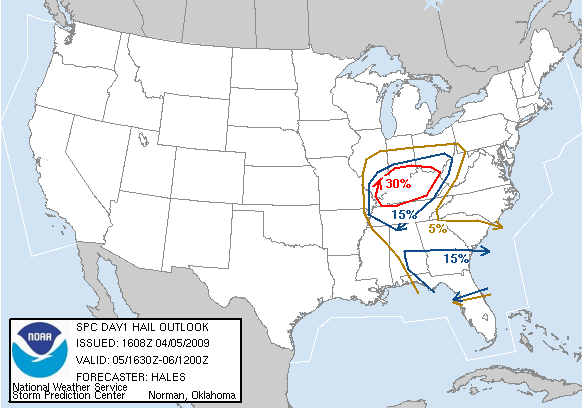
The SPC has our area in a fair risk category for Hail/Wind. Be prepared for this. We are in the 5% Tornado category. I expect to see a Thunderstorm or Tornado Watch to be issued for later this afternoon. Sunshine will push temps into the mid or upper 70s this afternoon and dewpoints will likely balloon as well. Development potential is there for very high cloud tops, meaning hail could be a very serious threat. Timing is also questionable as to when a line may form. My best estimate at this point is 6-7pm... maybe later. Everything should be cleared out by midnight.
After this afternoon/evenings weather, our next topic will be.... snow? I'm afraid so. We'll lay it out after this afternoon's models come in. We should have a much better take on the serious possibility of any accumulation.
Check back for more updates and keep your weather radio on and check that you are receiving the National Weather Service Channel.
Send weather pictures to: 991@scrtc.com
Chris Jessie
Saturday, March 28th, 2009... 6pm
A tornado watch is now posted for most of Western Kentucky... several Tornado Warnings are now in effect for counties west of Bowling Green. That line of storms will be arriving within the next hour/hour and a half. Please turn on your weather radios and your regular radios. I will be doing storm coverage live and it will be hard to post here during that coverage.
Check back for more updates.
Send weather pictures to: 991@scrtc.com
Chris Jessie
Tuesday, March 17th, 2009...1pm
Top o' the day to ya.... Happy St. Patrick's Day! I've been pinched once today... I am not wearing green. I'm not a fan of being poked or pinched, so needless to day I'm a little disappointed in myself.
As to the weather... a nice day to sit outside at the local pub... lower 70's this afternoon with sunny conditions. Tomorrow looks a little bit better, even. Mid 70's with sun. Clouds will roll in late, though with a chance of rain overnight and Thursday. No severe weather is expected.
GO CATS!!!! Look for me on ESPN tonight. I'll be right near the court for the UK game in the NIT!!!! I also want to shout out to Morehead St. Hope you get to play Louisville on Friday.
Check back for more updates.
Send weather pictures to: 991@scrtc.com
Chris Jessie
Friday, March 13th, 2009...7am
Anywhere from 1-3 inches reported over our area from last night. Several schools are closed... Go to the Snow Watch - Weather Watch page for Info. Things will warm up a bit today. Roads should be clear by mid-morning. Right now it's 32... temps will rise into mid-40's today.
Check back for more updates.
Send your backyard snow totals and weather pictures to: 991@scrtc.com
Chris Jessie
Thursday, March 12th, 2009...10pm
Lots of accidents are being reported around the area. DES in Hart County is dealing with several dispatches. There is a major accident on I-65... traffic is backed up near Munfordville at my last check. Many area schools are already calling off classes for Friday. Go to the Snow Watch - Weather Watch page for Info. Here's an updated NWS advisory:
...WINTER WEATHER ADVISORY REMAINS IN EFFECT UNTIL 8
AM EDT /7 AM
CDT/ FRIDAY...
A WINTER WEATHER ADVISORY REMAINS IN EFFECT UNTIL 8 AM EDT /7 AM
CDT/ FRIDAY.
SNOW...OCCASIONALLY MIXED WITH SLEET WILL CONTINUE OVER SOUTH
CENTRAL KENTUCKY FOR THE REST OF THIS EVENING. THE PRECIPITATION
WILL GRADUALLY DIMINISH OVERNIGHT AND COULD TURN TO LIGHT SLEET
AND/OR LIGHT FREEZING RAIN BEFORE ENDING. TOTAL SNOWFALL AMOUNTS
OF 1 TO 3 INCHES ARE EXPECTED IN MANY AREAS. DRIVERS SHOULD USE
MUCH CAUTION TONIGHT DUE TO SLIPPERY ROADS.
Check back for more updates.
Send your backyard snow totals and weather pictures to: 991@scrtc.com
Chris Jessie
Thursday, March 12th, 2009...5pm
Go Cards!!!! GO CATS !!!! Go Tops!!!!
A Winter Weather Advisory is in effect. I don't think we'll have major problems for travel overnight. Temps will just be below freezing a couple of degrees. That, combined with road treatment should be enough for everything wet on the surface. About .25 inches of snow/sleet is on the grass now. An area from Glasgow to Edmonton to Columbia saw heavy sleet this afternoon. About .5 inches of it fell during an hour from 2-3pm. It did not affect the roads because of warmer surface temps.
As for Friday morning... There may be a slick spot or two... especially east and south. If there are any closings/cancellations/delays, be sure and check out the Snow Watch - Weather Watch page.
256 PM EDT THU MAR 12 2009 /156 PM CDT THU MAR 12
2009/
...WINTER WEATHER ADVISORY IN EFFECT UNTIL 8 AM EDT /7 AM CDT/
FRIDAY...
THE NATIONAL WEATHER SERVICE IN LOUISVILLE HAS ISSUED A WINTER
WEATHER ADVISORY FOR SNOW AND SLEET...WHICH IS IN EFFECT
UNTIL 8 AM EDT /7 AM CDT/ FRIDAY.
A MIXTURE OF LIGHT SNOW AND SLEET WHICH HAS ALREADY SPREAD INTO
EXTREME SOUTH CENTRAL KENTUCKY THIS AFTERNOON WILL CONTINUE OVER
SOUTH CENTRAL KENTUCKY TONIGHT. AROUND ONE INCH OF SNOW AND SLEET
ACCUMULATION IS EXPECTED ROUGHLY ALONG AND SOUTH OF A LINE FROM
BOWLING GREEN TO RICHMOND INCLUDING THE CUMBERLAND PARKWAY. MOST
ACCUMULATIONS WILL OCCUR ON ELEVATED AND GRASSY SURFACES. HOWEVER
DRIVERS SHOULD USE CAUTION THIS EVENING AS SOME SLICK SPOTS MAY
DEVELOP ON ROADWAYS ESPECIALLY BRIDGES AND OVERPASSES.
A WINTER WEATHER ADVISORY MEANS THAT PERIODS OF SNOW AND SLEET MAY
CAUSE TRAVEL DIFFICULTIES

Check back for more updates.
Send your weather pictures to: 991@scrtc.com
Chris Jessie
Thursday, March 12th, 2009...7am
Forecast models are now pushing snow more to the south for overnight and into Friday morning. Areas stretching from Northeast Arkansas to West Virginia could see some heavy snow. For us, it really is up in the air... pun intended... as to what kind of precip and how much. If sleet falls here, there will be a lot less precip. If temps aloft support snow, some areas may see 2 or 3 inches.
Here's the latest NWS advisory:
Special Weather Statement
SPECIAL WEATHER STATEMENT
NATIONAL WEATHER SERVICE LOUISVILLE KY
510 AM EDT THU MAR 12 2009
...WINTRY MIX EXPECTED THIS AFTERNOON AND TONIGHT...
A WINTRY MIX OF RAIN AND SNOW WILL MOVE INTO SOUTHERN KENTUCKY
FROM THE SOUTH THIS AFTERNOON. PRECIPITATION WILL SPREAD NORTH TO
THE OHIO RIVER EARLY THIS EVENING. AFTER
SUNSET...PRECIPITATION SHOULD CHANGE TO MOSTLY SNOW THROUGH
MIDNIGHT WITH SLEET MIXING IN ACROSS SOUTH CENTRAL KENTUCKY.
LIGHT SNOW ACCUMULATIONS OF UP TO ONE INCH WILL BE POSSIBLE
THURSDAY NIGHT. WARM GROUNDS WILL LIMIT SNOW ACCUMULATIONS TO
ELEVATED SURFACES AND GRASSY AREAS.
IT SHOULD BE NOTED THAT THERE IS STILL SOME UNCERTAINTY CONCERNING
PRECIPITATION TYPE ACROSS SOUTH CENTRAL KENTUCKY...AND FUTURE FORECASTS
SHOULD BE MONITORED FOR CHANGES. ANY SHIFT IN TEMPERATURE AND
MOISTURE PROFILES WILL CHANGE PRECIPITATION TYPE AND AMOUNT.
Check back for more updates.
Send your weather pictures to: 991@scrtc.com
Chris Jessie
Wednesday, March 11th, 2009...7pm
Highs for Thursday have steadily been lowered in the previous 3-4 forecast updates. It looks like we will only get a notch or two above freezing. This is setting up a pretty interesting late winter scenario. March winter situations are usually the most erratic of the winter season. Heavy snow is forecast off to our west.
Here's the afternoon NWS advisory for our area
...WINTRY PRECIPITATION POSSIBLE THURSDAY AFTERNOON
THROUGH THURSDAY NIGHT...
A WINTRY MIX OF RAIN AND SNOW WILL MOVE INTO SOUTHERN KENTUCKY
FROM THE SOUTH THURSDAY AFTERNOON. PRECIPITATION WILL SPREAD
NORTH TO THE OHIO RIVER EARLY THURSDAY EVENING. AFTER
SUNSET...PRECIPITATION SHOULD CHANGE TO MOSTLY SNOW THROUGH
MIDNIGHT WITH SLEET MIXING IN ACROSS SOUTHERN KENTUCKY. AFTER
MIDNIGHT...DRY AIR ALOFT WILL CAUSE SNOW TO CHANGE TO LIGHT
FREEZING RAIN THROUGH SUNRISE.
LIGHT SNOW ACCUMULATIONS OF UP TO ONE INCH WILL BE POSSIBLE
THURSDAY NIGHT. WARM GROUNDS WILL LIMIT SNOW ACCUMULATIONS TO
ELEVATED SURFACES AND GRASSY SURFACES. LITTLE TO NO ICE
ACCUMULATION IS EXPECTED.
IT SHOULD BE NOTED THAT THERE IS STILL SOME UNCERTAINTY IN THIS
FORECAST...AND FUTURE FORECASTS SHOULD BE MONITORED FOR CHANGES.
ANY SHIFT IN TEMPERATURE AND MOISTURE PROFILES WILL CHANGE
PRECIPITATION TYPE AND AMOUNT.
Check back for more updates.
Send your weather pictures to: 991@scrtc.com
Chris Jessie
Tuesday, March 10th, 2009 1pm...
Clouds will keep us from record highs today.... 72 right now at the Glasgow Airport (official). Averages are 56 for a high and 34 for a low. The record high for today is 82 (Bowling Green) from back in 1990. The same sun we saw yesterday would likely push us up to or over that.
A surface low and it's associated stationary fronts have kept SoKy in the "pocket" for several days, now. A nice southerly breeze has made for very comfortable conditions to be out and about. That will change by Thursday. Rain moves in tonight late and is with us for Wednesday. Colder tomorrow night as we dip below freezing again. Mid 40's are expected for Thursday afternoon.
We're not expecting any severe weather overnight. SPC doesn't really anticipate major severe weather in our area and only supports a slight risk for extreme western KY. However, winds will be gusty overnight.... 25-30mph at times. Also, storms that do move through could dump heavy rain. Minor flooding could be an issue with already saturated surfaces.
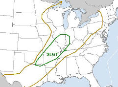
Check back for more updates.
Send your weather pictures to: 991@scrtc.com
Chris Jessie
Monday, March 9th, 2009...1pm
Very nice day... Sunny and mid 60's this afternoon. Showers/rain return early morning Tuesday and afternoon and evening rain/t-storms will be on the menu. Right now SPC has Southern Illinois in a slight risk area for severe storms. We are not in a risk area at this time, although some of the storms late on Tuesday could be strong. Tomorrow's convective outlook may be updated to put our area in a slight risk category, but it doesn't look like were going to see a major outbreak.
Are you adjusted to the time? I'm NOT!!!! Pretty draggy day. Need to get out and shoot some hoops.
Check back for more updates.
Send your weather pictures to: 991@scrtc.com
Chris Jessie
Sunday, March 8th, 2009...4pm
Tornado Warning for parts of Grayson County...
* TORNADO WARNING FOR...
SOUTHERN BRECKINRIDGE COUNTY IN NORTH CENTRAL KENTUCKY...
EASTERN OHIO COUNTY IN NORTHWEST KENTUCKY...
NORTHWESTERN GRAYSON COUNTY IN SOUTH CENTRAL KENTUCKY...
* UNTIL 430 PM CDT...
* AT 343 PM CDT...NATIONAL WEATHER SERVICE DOPPLER RADAR INDICATED A
SEVERE THUNDERSTORM CAPABLE OF PRODUCING A TORNADO 30 MILES WEST OF
LEITCHFIELD...MOVING EAST AT 55 MPH.
* THE TORNADO WILL BE NEAR...
7 MILES NORTH OF LEITCHFIELD BY 415 PM CDT...
THE SAFEST PLACE TO BE DURING A TORNADO IS UNDER A WORK BENCH OR
OTHER PIECE OF STURDY FURNITURE IN A BASEMENT. IF NO BASEMENT IS
AVAILABLE...SEEK SHELTER ON THE LOWEST FLOOR OF THE BUILDING IN AN
INTERIOR HALLWAY, BATHROOM, OR CLOSET. USE BLANKETS OR PILLOWS TO
COVER YOUR BODY. AVOID WINDOWS.
A Tornado Watch in effect until 7pm central for Hart, LaRue, Hardin, Grayson, Edmonson, Barren, Warren and Allen Counties in our listening area. Several warnings have already been issued from these storms. Here's the NWS statement:
A TORNADO WATCH IS IN EFFECT UNTIL 800 PM EDT TONIGHT.
A COLD
FRONT WILL MOVE THROUGH THE REGION LATE THIS AFTERNOON AND
EVENING. STRONG TO SEVERE THUNDERSTORMS WILL ACCOMPANY THE FRONT
AS IT MOVES THROUGH THE AREA. DAMAGING WINDS...LARGE HAIL AND
ISOLATED TORNADOES WILL BE POSSIBLE WITH THIS ACTIVITY. IN
ADDITION...WINDS ARE EXPECTED TO BE QUITE GUSTY AFTER THE
THUNDERSTORMS MOVE THROUGH. SUSTAINED WINDS OF 15 TO 20 MPH WITH
GUSTS TO 35 MPH WILL BE POSSIBLE THIS EVENING BEFORE SUBSIDING OVERNIGHT.
Be sure your weather radio is on. If any warnings are issued for our local area, I'll be on air for coverage, so tune in.... 99.1 FM or 1150 AM... listen live online by clicking here.
Check back for more updates.
Send your weather pictures to: 991@scrtc.com
Chris Jessie
Thursday, March 5th, 2009...3pm
Saw a couple of cold-core funnels today. These are rotating columns of sinking cold air... much like a drain swirl. These are literally funnel clouds thousands of feet up. There is not any danger usually associated with these types of upper atmosphere phenomenon. Here's a great link to a site with some awesome info and some good photos of exactly what I observed in Southern Hart County/Northern Barren County.
|
Photo from linked site: |
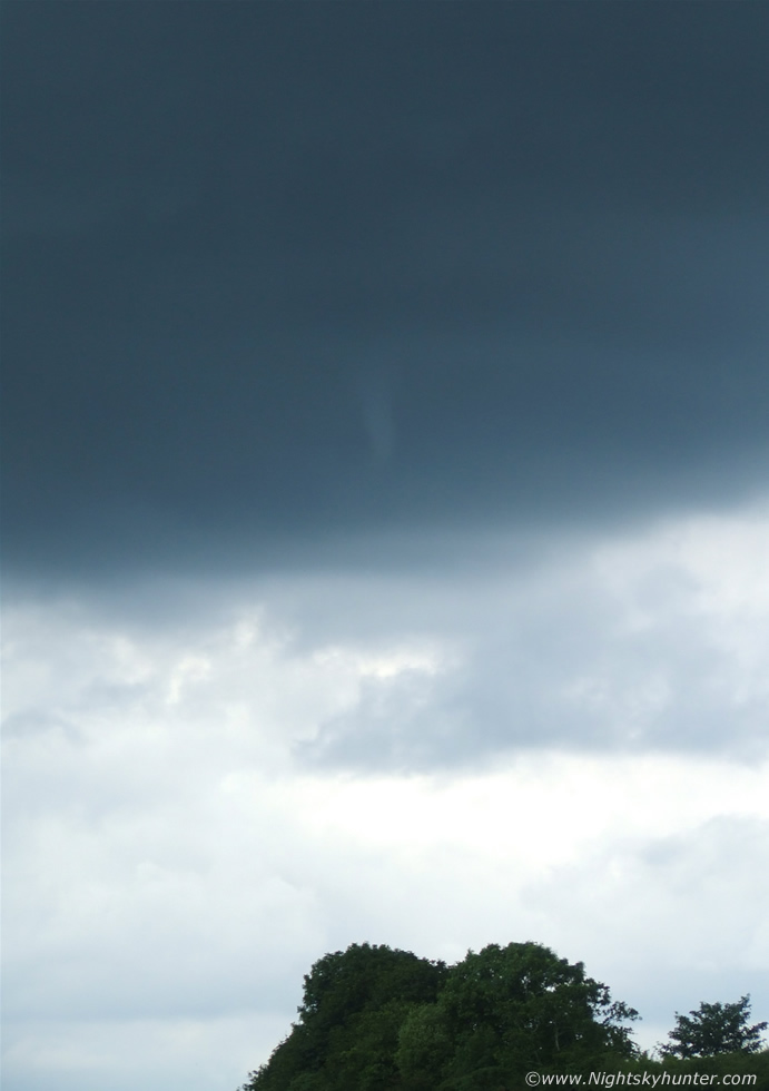 |
Warm week to end up... a few showers, too. Mid-70's for Saturday. Guess I'll be getting the lawnmower ready, spreading fertilizer and weed preventer this weekend. Good time to put down crabgrass treatment. Also, a good time to set tree spike fertilizers and do a first mowing to get the shag out.
This weekend, time changes. Spring forward early Sunday morning.
Have a great weekend.
Check back for more updates.
Send your weather pictures to: 991@scrtc.com
Chris Jessie
Tuesday, March 3rd, 2009...3pm
Last cold day for us.... at least in the foreseeable future. Temps will rebound nicely by week's end... maybe to the 70 mark by Friday. A shower chance will be popping up late week and for the weekend, though temps will still be quite warm... 60's for Saturday and Sunday. Looks like we'll start of the following week in the 60 range, too.
High School Basketball regional games are underway this week. Hope your team does well!!! It's my favorite time of the year with respect to sports.... Gotta love March Madness!
Our stations are having a great Final Four contest coming up in a few weeks. Be sure you check back on the sites and listen to the radio for more details.
Check back for more updates.
Send your weather pictures to: 991@scrtc.com
Chris Jessie
Thursday, February 26th, 2009...10am
Rain for us early should come to an end mid-day and then be back for late tonight. A severe weather threat exists for much of Arkansas and Illinois later this afternoon/evening. I don't believe these storms will be severe as they push east across Kentucky. The SPC has our area in only a 5% chance of wind/hail.
Have I jumped the gun??? I said that we may be finished with winter... not so fast. Although the precip/rain was in the forecast for late this week, we didn't see the temps falling this low. Now, it looks like that Saturday's high will only be around 35.... with night lows in the mid-upper 20's. If there's any moisture being drawn up into this, we could see accumulating snow. Deepening moisture for this system should be far more south than previous systems of January and early February. For a change, it looks like any snow that does fall will be in our area - east or even a bit south. Timing is important and the models are really fussing over what do with precip.
Officials from Kentucky have now put a price tag on January's Ice Storm.
Here's an AP Wire release:
FRANKFORT, KY (AP) - State and federal officials say damage estimates from
the January ice storm will likely top $185 million. Kentucky's Emergency
Management director, Brig. Gen. John W. Heltzel, says the damages were
primarily related to the state's electric utilities. A statement from the
joint field office, which includes FEMA officials, says the final figure
will be higher. Teams of recovery specialists
have been calculating the damage estimates since a Feb. 5 federal disaster
declaration by President Barack Obama for 93 Kentucky counties. The order
allows local governments and nonprofit organizations to be reimbursed for
disaster-related expenses. The USDA also said in a
statement Wednesday that it will spend $900,000 on storm cleanup in
Kentucky.
I'll be following developments for potential severe weather overnight and for winter weather this weekend. Check back for more updates.
Send your weather pictures to: 991@scrtc.com
Chris Jessie
Monday, February 23rd, 2009...12 Noon
A warm up is on the way. Hope you enjoyed the snow from Saturday night. Kids in my neighborhood were up and sledding the hill early Sunday morning.
Be sure and check out the Comet, Lulin... It passes closest to us on Tuesday night and it is visible to the eye. It is spectacular through a telescope or even binoculars.
Here is a link to detailed info on the comet: Comet Lulin
Now, back to earth:
The warmer conditions settle in for mid/late week. Mid 60's not out of the question for Thursday. Rain will be coming with the late week warmth, though. Staying long range... no shots of winter (temp or precip) are in the next two weeks, unless some changes are indicated. Repeating my comment from Friday, "... we may be passing up our last shot for an accumulating snow this winter."
If you like snow, the clipper that moved through our area on Saturday night is responsible for 26" in the Caribou area of Maine. ROAD TRIP!
Golf index is high through Wednesday. Enjoy.
Check back for more updates.
Send your weather pictures to: 991@scrtc.com
Chris Jessie
Friday, February 20th, 2009...10am
Well folks... we may be passing up our last shot for an accumulating snow this winter. Saturday should be mostly rain here. Snow accumulations (if any) will mostly be north and east of us.
NWS Louisville Says:
.DAY ONE...TODAY AND TONIGHT.
SOME LIGHT RAIN OR SNOW COULD REACH PARTS OF SOUTHERN INDIANA AND
CENTRAL KENTUCKY IN THE LATE NIGHT HOURS TONIGHT. WITH TEMPERATURES
NEAR THE FREEZING MARK...SOME SLICK SPOTS COULD DEVELOP...ESPECIALLY
ON ELEVATED SURFACES...BRIDGES AND OVERPASSES.
.DAYS TWO THROUGH SEVEN...SATURDAY THROUGH THURSDAY.
LIGHT ACCUMULATING SNOW IS POSSIBLE...ESPECIALLY ACROSS SOUTHERN
INDIANA AND NORTH CENTRAL KENTUCKY...LATE SATURDAY AFTERNOON INTO
THE OVERNIGHT HOURS. AT THIS TIME...ACCUMULATIONS OF AROUND AN
INCH ARE EXPECTED IN THESE AREAS. FURTHER SOUTH ACROSS SOUTH
CENTRAL KENTUCKY THE PRECIPITATION WILL REMAIN PRIMARILY RAIN OR A
RAIN AND SNOW MIX UNTIL MIDNIGHT WHEN PRECIPITATION WILL
TRANSITION TO SNOW. ONLY MINOR ACCUMULATIONS...IF ANY...ARE
EXPECTED AT THIS TIME ACROSS SOUTH CENTRAL KENTUCKY. SLICK SPOTS
MAY DEVELOP ON ROADWAYS AS TEMPERATURES FALL INTO THE 20S DURING
THE OVERNIGHT HOURS.
Long range temps: Look very warm... first week of March, we might flirt with the 80's? It does look like we'll be breaking the cold pattern for at least the next couple of weeks.
Thanks for all the e-mails of appreciation for storm coverage from Wednesday. It is very rewarding to hear from all the folks who say they depend on our stations for weather.
If you have any hail pics from Wednesday, be sure and e-mail them to me. I'll be glad to post them.
Check back for more updates.
Send your weather pictures to: 991@scrtc.com
Chris Jessie
Thursday, February 19th, 2009...8am
Wild day on Wednesday... check out some of the NWS Local Storm Reports:
1155 AM HAIL 8 NE SCOTTSVILLE 36.83N 86.09W
02/18/2009 E1.75 INCH ALLEN KY LAW ENFORCEMENT
GOLF BALL SIZE HAIL REPORTED TO SCOTTSVILLE POLICE NEAR
BARREN RIVER LAKE ON BAILEYS POINT ROAD
0141 PM HAIL 4 NW ALBANY 36.73N 85.19W
02/18/2009 E1.75 INCH CLINTON KY BROADCAST MEDIA
GOLF BALL HAIL COVERING GROUND
0142 PM HAIL 1 E CUMBERLAND CITY 36.80N 85.05W
02/18/2009 E1.75 INCH CLINTON KY EMERGENCY MNGR
COVERING THE GROUND 2 INCHES DEEP
Today the temps will rise to just above freezing, but the gusty winds will
make it feel quite a bit cooler.
I am continuing to watch each to model run for the weekend snow outlook. NAM and GFS runs continue to trend towards a secondary system dumping at least some snow in the region. We'll see how things unfold for Saturday.
If you have any hail pics from Wednesday, be sure and e-mail them to me. I'll be glad to post them.
Check back for more updates.
Send your weather pictures to: 991@scrtc.com
Chris Jessie
Friday, February 13th, 2009...6am
Today will be another great day.. at least for mid-February. Temps will rise into the upper 50's. A couple of smaller disturbances will move through this weekend. The first overnight with a few showers into Saturday morning.... and the second Sunday night into Monday. Temps will be above freezing for the most part until Sunday night... lows should fall back into the upper 20's... that will also come with a chance of snow showers. Doesn't look like anything significant, though.
Local weather notes for this date:
13 February 1899 Lexington's coolest February temperature: -20
degrees. Coldest temperature on record at Irvington (-25), Leitchfield
(-26), Richmond (-24), and Russellville (-22).
13 February 1960 Bowling Green's snowiest February day, with 7 inches.
13 February 1989 Lexington's wettest February day: 3.10 inches of
precipitation.
Have a great Friday the 13th... and a great weekend.
Check back for more updates.
Send your weather pictures to us. 991@scrtc.com
Chris Jessie
Wednesday, February 11th, 2009...11am
Tornado Watch for our area just posted...until 5pm central time. Hart, Metcalfe and ALL SURROUNDING COUNTIES ARE INCLUDED in this watch:
ADAIR ALLEN ANDERSON
BARREN BOONE BOURBON
BOYLE BRACKEN BRECKINRIDGE
BULLITT BUTLER CAMPBELL
CARROLL CASEY CLARK
CLINTON CUMBERLAND DAVIESS
EDMONSON FAYETTE FRANKLIN
GALLATIN GARRARD GRANT
GRAYSON GREEN HANCOCK
HARDIN HARRISON HART
HENRY JEFFERSON JESSAMINE
KENTON LARUE LINCOLN
LOGAN MADISON MARION
MASON MCLEAN MEADE
MERCER METCALFE MONROE
MUHLENBERG NELSON NICHOLAS
OHIO OLDHAM OWEN
PENDLETON ROBERTSON RUSSELL
SCOTT SHELBY SIMPSON
SPENCER TAYLOR TODD
TRIMBLE WARREN WASHINGTON
WOODFORD
The National Weather Service Conference Call from just a bit ago featured some interesting discussion. The NWS has never dealt with a high wind warning and a tornado watch at the same time. The ice storm conditions complicate and increase the danger of this system. Expect squall line development west of I-65 between 11am-1pm. The line will move east rapidly and should be even stronger east of I-65. A secondary line will likely form as the second one breaks up.
Here is discussion from the Storm Prediction Center:
THREAT FOR
DAMAGING WINDS IS FORECAST TO SLOWLY INCREASE THIS
AFTERNOON...AHEAD OF QUICKLY-MOVING CONVECTIVE LINE. WW MAY
EVENTUALLY BE REQUIRED.
LATEST RADAR SHOWS A FAIRLY WELL-DEFINED BUT LOW-TOPPED LINE OF CONVECTION
MOVING QUICKLY EWD ACROSS WRN KY/WRN TN/NERN MS. MORNING SOUNDINGS REVEAL
LITTLE IF ANY INSTABILITY...WITH THE CONVECTIVE LINE SUSTAINED PRIMARILY BY
STRONG FORCING ALONG THE SURFACE FRONT. AS THE UPPER SYSTEM NOW CROSSING THE
OZARKS TAKES ON AN INCREASINGLY-NEGATIVE TILT...THE SURFACE FRONT -- AND
ASSOCIATED CONVECTIVE LINE -- SHOULD ACCELERATE EWD. WITH VERY STRONG
DEEP-LAYER WIND FIELD ACROSS THIS REGION...EVEN SLIGHT INTENSIFICATION OF
THE CONVECTIVE LINE WILL INCREASE THE LIKELIHOOD OF TRANSPORTING STRONGER
WINDS TO THE SURFACE.
Please check weather radios and be sure that you are receiving a good signal. They will likely be activated later this afternoon.
Hart County Schools are closed today.
Check back for more updates.
Send your weather pictures to us. 991@scrtc.com
Chris Jessie
Wednesday, February 11th, 2009... 6:30am
A High Wind Warning is in effect for our region today. Here's the NWS advisory in detail:
High Wind Warning
URGENT - WEATHER MESSAGE
NATIONAL WEATHER SERVICE LOUISVILLE KY
345 AM EST WED FEB 11 2009 /245 AM CST WED FEB 11 2009/
...HIGH WIND WARNING REMAINS IN EFFECT FROM 7 AM EST /6 AM CST/
THIS MORNING TO 10 PM EST /9 PM CST/ THIS EVENING...
A HIGH WIND WARNING REMAINS IN EFFECT FROM 7 AM EST /6 AM CST/
THIS MORNING TO 10 PM EST /9 PM CST/ THIS EVENING.
SOUTH TO SOUTHWEST WINDS OF 20 TO 35 MPH WITH GUSTS TO 45 MPH
EARLY THIS MORNING WILL INCREASE TO 25 TO 40 MPH WITH GUSTS UP TO
55 MPH BY EARLY THIS AFTERNOON. THESE WINDS OF 25 TO 40 MPH WITH
GUSTS TO 55 MPH WILL CONTINUE INTO THIS EVENING BEFORE DECREASING
EARLY TONIGHT.
IN ADDITION...A STRONG COLD FRONT
WILL MOVE THROUGH THE REGION
DURING THE DAY BRINGING A LINE OF STRONG TO SEVERE THUNDERSTORMS
TO THE AREA LATE THIS MORNING THROUGH THIS AFTERNOON. WIND GUSTS
WITHIN THIS LINE OF STORMS COULD EXCEED 60 MPH.
WINDS OF THIS STRENGTH COULD RESULT IN WIDESPREAD DAMAGE ACROSS
THE REGION AND COULD CAUSE ALREADY LOOSENED BRANCHES AND TREES
FROM THE RECENT ICE STORM TO FALL...POTENTIALLY RESULTING IN
POWER OUTAGES TODAY AND TONIGHT. ANYONE WITH OUTDOOR INTERESTS
WILL BE AFFECTED BY HIGH WINDS...AND TRAVELERS WILL FIND
NAVIGATING THROUGH THE HIGH WINDS DIFFICULT...ESPECIALLY THOSE
TRAVELING IN HIGHER PROFILE VEHICLES.
Hart County Schools are closed today.
Thursday, February 5th, 2009...6am
Sorry it has been a few days since my last post. Lots going on behind the scene.
Cold... brrrr. We're reading 7 now at the studio. Frankfort is reporting the lowest temp this morning at -3. Lexington is reporting 0. They have snow on the ground... that's holding down the temps.
We should make it to just above freezing here today.... more coming later.
Check back for more updates.
Send your pics from the ice storm to us. 991@scrtc.com
Chris Jessie
Monday, February 2nd, 2009...4pm
The boil water advisory for Munfordville is lifted (as of noon Monday).
Residents in the Bonnieville water district remain under a boil water advisory.
Judge Executive N.E. Reed of
Edmonson County says that all of Edmonson County Water District customers in
Hart County remain under a boil water advisory until further notice. He says
pressure should continue to slowly rise. He says pressure which was building
after pumping resumed from the power outage was lost because an anchor was
driven through a pipe. He says that issue is now repaired and pumping
continues. All residents of the water district should see water service
return and continue to build.
No significant change in the 24-hour forecast.
Check back for more updates.
Send your pics from the ice storm to us. 991@scrtc.com
Chris Jessie
Monday, February 2nd, 2009...10am
First... Happy Birthday to my mother, Hazel Jessie..! Love ya, Mom.
Now... Boil water advisories for Green River Water customers have been lifted except for those in the city limits of Munfordville. Also, Edmonson County Water customers remain under the boil water advisory (for those who have running water). I've not heard an update on the status of power for their treatment facility (Edmonson Water) since Saturday.
Weather: Look for another cold snap here to the middle of the week. The snow will by-pass us, though, with only flurries/light snow showers expected through Wednesday... only a dusting or trace is expected with some higher accums as you head into the eastern part of the state. Lows tonight... 25. Highs Tuesday...33. Tuesday night...16. Wednesday's high...30. Wednesday night...18. We should see a warm up by end of the week... 50's by Friday.
Check back for more updates.
Send your pics from the ice storm to us. 991@scrtc.com
Chris Jessie
Sunday, February 1st, 2009...6pm
No School in Hart County, Edmonson County, LaRue County or Hardin County on Monday. Lots of damage still to sift through. Good new on the weather: 65 for a high on Sunday... that's about 10 degrees above the forecast high. That allows everything to melt completely and also allows some drying out. The ground is very saturated. Overnight we will see some showers/snow showers. Shouldn't see anything major. The snow forecast has shifted well to the east and north of us. Tuesday could allow for some light accumulations. Monday's high will be around 40, and then we'll have another cold snap to deal with. High temps on Tuesday of only 29. Tuesday and Wednesday night's... temps fall into the mid/upper teens.
NWS product:
330 PM EST (230 PM CST) SUN FEB 1 2009
THIS HAZARDOUS WEATHER OUTLOOK IS FOR PORTIONS OF SOUTH CENTRAL
INDIANA AND CENTRAL KENTUCKY.
TONIGHT.
LIGHT RAIN OR SNOW WILL BE POSSIBLE ACROSS SOUTH CENTRAL AND EAST
CENTRAL KENTUCKY AFTER MIDNIGHT. ALTHOUGH LITTLE PRECIPITATION IS
EXPECTED LOCATIONS THAT DROP BELOW THE FREEZING MARK TONIGHT MAY
EXPERIENCE SOME SLICK SPOTS ON BRIDGES AND OVERPASSES TOWARD MORNING.
MONDAY THROUGH SATURDAY.
A COLD NORTHWEST FLOW WILL BRING A CHANCE OF SCATTERED LIGHT SNOW
SHOWERS FROM LATE MONDAY THROUGH WEDNESDAY...WITH THE BEST CHANCE
OCCURING OVER THE NORTHERN HALF OF THE AREA DURING THIS TIME FRAME.
THE MOST LIKELY PERIOD FOR MINOR SNOW ACCUMULATIONS WILL BE TUESDAY.
ANY ACCUMULATIONS WILL BE LIGHT.
Check back for more updates.
Send your pics from the ice storm to us. 991@scrtc.com
Chris Jessie
Saturday, January 31st, 2009...2pm
Quick update... Many residents of KU and FRECC in our area can expect power outages to last 3-5 days more. Some extreme cases may be much longer than that.. maybe even 3 to 5 weeks. Crews continue to set poles, replace lines and restore service. They are working as best they can. Assistance is coming in from other utility companies.
Boil water advisory update: All Green River Water customers and all Edmonson County Water customers should continue to boil any water before human consumption. Many area restaurants are closed and other food/retail outlets for food are closed. Some are open serving limited menus and have limited services (for example: service with plastic/paper plates, cups and utensils).
Shelters remain open at the sites indicated on our WLOC and WHSX homepages. If you know of someone running generators and you think they may not be vented enough, please inform them of the carbon emissions dangers. Several people have been found dead in their homes of Carbon poisioning.
As hard as it may be to believe, areas in Grayson/Edmonson/Butler/Hardin Counties are in just as bad if not worse shape than we are here in the Heart Of Kentucky. In Hart County, the areas from Bonnieville to Cub Run and over into the Edmonson/Grayson/Hardin County lines is the most devastated of all our listening area.
Please check in on elderly/sick neighbors that you know of who may be without power.
Weather: Today a lot of melting is taking place. Lots of ice falling.... please use caution while passing under trees or power lines on the roadways. Also, don't park under trees... ice can cause lots of damage as it falls. Tomorrow should take care of all the ice. Temps in the 50's will be more than enough to thaw. Soggy ground and flooding conditions continue in some places. That will stay the case as ice melts and as we see more precip into the new week. Starting as rain Sunday night... still possibility of accumulation on early/mid Monday.
Check back for more updates.
Send your pics from the ice storm to us. 991@scrtc.com
Chris Jessie
Friday, January 30th, 2009...11am
Several patches of snow are showing up on radar. A lot of it is not reaching ground, although the heavier intensity areas are actually getting a dusting. No road problems are expected. NWS forecasts temps for our area to only reach about 30 for today, however we are sitting on 34 (surface) right now at 11am.
NWS product:
1123 AM EST FRI JAN 30 2009 /1023 AM CST FRI JAN 30
2009/
...SCATTERED SNOW SHOWERS WILL CONTINUE...
SNOW SHOWERS WILL CONTINUE TO AFFECT PORTIONS OF SOUTH-CENTRAL
INDIANA AND CENTRAL KENTUCKY THROUGH THE EARLY AFTERNOON HOURS.
THROUGH 1PM EST...THE HEAVIEST SNOW SHOWERS WILL AFFECT THE
NORTHERN BLUEGRASS...MAINLY ALONG AND NORTH OF I-64. OTHER HEAVIER
SNOW SHOWERS WILL AFFECT PORTIONS OF CENTRAL KENTUCKY WEST OF
I-65. THESE SNOW SHOWERS MAY BE BRIEFLY HEAVY...WITH A QUICK
DUSTING UP TO A HALF INCH POSSIBLE. THIS WILL ALSO BRIEFLY REDUCE
VISIBILITIES AND CAUSE ADDITIONAL SLICK SPOTS...SO USE CAUTION
WHILE DRIVING.
Check back for more updates.
Send your pics from the ice storm to us. 991@scrtc.com
Chris Jessie
Friday, January 30th, 2009...8am
Thanks for all the e-mails. I have enjoyed reading them and your comments have been very much appreciated. It's impossible to respond to them all, so please accept this as a reply of thanks.
I've actually been trying to catch up on other station work. The last few days, I've had to let a lot go in order to keep up with the weather. We've also been very busy trying to stay on the air with our emergency power supply. Electric lines and poles remain down at our hill-top transmitter site.
Green River Valley Water Customers remain under a boil water advisory. Customers have been asked to conserve water so that supply volume can reach a level for quality samples to be taken. Until then, people will have to boil water for human consumption. The treatment facility remains without electric service from Kentucky Utilities and is running on generator power. This advisory is for ALL customers of the utility.
Weather: Light snow showers for some of us today. Warmer this weekend... in the 50's for Sunday. Melting will take place. Be aware of falling ice from trees and from power lines that hover over roadways. Snow storm still possible for first part of the week. I'll have details later this afternoon.
Check back for more updates.
Send your pics from the ice storm to us. 991@scrtc.com
Chris Jessie
Thursday, January 29th, 2009... 9:30am
A 10am press conference is scheduled in Munfordville for the purpose of detailing situations with Green River Valley Water and electric service in the area. We will have details after that conference. Weather is looking better by the weekend. Some significant melting will take place this weekend. Cold today and tomorrow, though. Coming up later today... details on possibility for an early week snow/rain event.
Check back for more updates.
Send your pics from the ice storm to us. 991@scrtc.com
Chris Jessie
Wednesday, January 28th, 2009...5pm
Back To The Weather: Tonight it will be cold. Precip is over until tomorrow night. Lows tonight will be in the mid teens. Partly cloudy tomorrow... the sun should help burn off most ice and snow.. highs around 34. Friday.... cold upper 20s with lows on Friday night in the lower teens. Warmer for the weekend.
Outlook for Monday... New system moves in for Sunday night/Monday... could be rain, could be snow. We'll see about all that later.
Check back for more updates.
Send your pics from the ice storm to us. 991@scrtc.com
Chris Jessie
***4:45pm Update
This is from the Barren River Health District:
The Barren River District Health Department has issued an immediate closure
notice for all retail markets, food service establishments and other
facilities engaged in the preparation and service of food to the public,
that are served by the Green River Valley Water District.
This closure is issued as a result of the failure of electrical service
serving the water treatment plant. This failure has resulted in the loss of
water and water pressure throughout the system and a Boil Water Advisory has
been issued. This closure affects all permitted food establishments served
by the Green River Valley Water District. These establishments are to remain
closed until they are permitted to reopen by the Health Department.
Owners/ operators of such businesses should contact your local Health
Department between the hours of 8:00 A.M. and 4:30 P.M., for further
information and to arrange for inspection prior to reopening.
***4:30pm Update
A Generator Backup system is being trucked in this evening to provide electric to the Green River Water facility in Canmer. Some water service might be available for tomorrow morning. Hear the latest in Dewayne Forbis' report which is posted below.
***4pm Update
Big press conference just wrapped up in Munfordville about state of Hart County. It includes information on the Green River Water's power issue.
Here's Dewayne Forbis' report.
***3pm Update
Cave City residents are starting to report water out.
Some area restaurants are closed. I talked to Cracker Barrel's (Cave City) on-duty manager. She said they were closed for dining. When I asked about other information, she referred me to Cracker Barrel's home office or to the Barren County Health Department.
I talked with Pizza Hut Manager and Munfordville Mayer John Johnson... He says his restaurant still has potable water. And, that as long as his facility has that (under pressure) they will remain open.
Hart County and Caverna Schools are out the rest of the week based on road conditions and the water situation.
Hospital/Nursing facilities are having to get fresh supplies of water from alternate sources.
***2pm Update
Hardyville Area Water Pressure - Out
Horse Cave Area Water Pressure - Out
***1pm Update
Green River Valley Water Customers
Rumors of water being shut off
are false. Water is not being shut off.
There is no power at the facility in Canmer.
All GRVW customers are under
a boil water advisory.
Supplies may run low or
run out if power is not
restored at their treatment plant.
(more info coming in, please refresh this page)
Reporting: Chris Jessie, WLOC/WHSX
Adrian Gossett from Green River Valley water has first hand given us this information.
A boil water advisory is in effect for ALL customers of Green River Valley Water. This is because there is no power at the treatment facility at Canmer. Regardless of where you live, if you are a GRVW customer, you should follow boil water guidelines. According to Mr. Gossett, they must issue an advisory any time there is a situation with these circumstances. No lines are broken.
Good water supplies may run low.
Gossett says that because there is no power, the plant can not treat water and can not pump water out for distribution. Therefore, when tanked supplies run out... treated water will simply be gone... not be shut off.
Gossett says that he talked with Kentucky Utilities representatives... They have told him power will not be restored today to the treatment facility and that it is likely that power will not be restored on Friday. Gossett added he understands the overwhelming demand placed on KU to restore power to it's customers, but says that he did convey (to KU) the importance of restoring power to the water treatment facility at Canmer.
We greatly appreciate Mr. Gossett's time for interview. We know he and others at Green River Water are extremely busy.
-----------------------------------------------------------------
Tip: Area residents who still have water supply should bottle up a supply of drinking water for later use. Remember to boil it.
Tip: Those who lose water... Turn off your hot water heaters. It could prevent damage to your heater and it could also save on energy cost. It may even keep you more safe... Especially those who may have gas/propane water heaters. When heater tanks empty out there is a greater fire hazard with those appliances if they are left in operation.
Shelter remains available at Munfordville Elementary School for residents who are without power and heat.
Horse Cave mayor Odell Martin stated to us that any residents needing drinking water or who are in need of heat because of power loss, please contact the Horse Cave Fire Department or Police Department. He says they will help in any way they can.
_________________________________________________________________
***10:15 Update
Wow... the snow has packed up and moved out about the most quickly I've ever witnessed. The cold air push has ram-rodded the Ohio Valley region. Temps in Glasgow at the airport now are at 28 and falling. Re-freezing of water from overnight is creating a lot of ice on the roads. I've seen a peak or two of sun in the last hour. Precip is over for this system.
***9:45 Update
Snow has ended here. 1.5 inches at my home/studio. SW winds are picking up. Outside, you can still hear the crashing down of limbs in the distance.
***9:30am Update
Snow will be ending in western portion of area soon...temps are dropping quick... already down to 24 in E-town/Hodgenville. 1-2 inches of snow being reported in Hart/Green Counties. Around one inch in parts of Northern Barren and Metcalfe Counties.... less than an inch south of that.
The cold is drying up the air very quick. Bad news: re-freezing...and it will do it pretty quickly. Ponding of water from overnight will freeze. And I expect to see more tree/limbs down because of the brittle nature of frozen wood. Add to that... winds will pick up some. Trees that hit power lines could potentially cause more power outages.
***9:15am Update
Southern Indiana reports areas of 1 1/2 inches of ice. That's more than double what we experienced night before last.
Concerning Issue: Winds behind the snow are getting up to 25-30 mph...reported in Louisville and Evansville. Considering the ice still on everything, this is potentially as dangerous as the ice covering, itself. Already stressed tree limbs will be more brittle with the upper teen temps that are on the way for this evening/overnight. Point being: More downed limbs and power lines are possible.
Wednesday, January 28th, 2009....9am
Moderate snow continues across most of the area. The change from freezing rain to sleet then snow will only take about 15-20 minutes... maybe less... if you haven't seen it change yet.
Wednesday, January 28th, 2009...8:45
Updated info: State-wide... now 300,00 residents without power.
Local: FRECC says 7500 still without electric... mostly in Hart and Barren Counties.
WLOC and WHSX remain off air and without power at our transmitter relay sites.
Additional crews are coming in for assistance with local utilities.
National Guard assistance is being utilized in clearing debris from roads and from around power lines.
REMEMBER: DO NOT go near downed power lines. They may be or could become live at any time. Report them to authorities.
Hart County: Shelter is now set up for those needing a place with heat. Residents can come to Munfordville Elementary School.
Some Green River Valley Water customers still without water service.
SCRTC continues to work at restoring phone/tv/internet services.
Wednesday, January 28th, 2009...8:30am
Rain to heavy snow now starting to change over in northern listening area. Sleet/snow burst will accumulate quickly. Travel is becoming very dangerous again.
Still expecting around 2 inches by mid-day, before tapering off.
More coming.
Check back for more updates.
Send your pics from the ice storm to us. 991@scrtc.com
Chris Jessie
Wednesday, January 28th, 2009...6:45am
State officials say now 100,00 Kentuckians are without power after last nights ice in northern parts of the Commonwealth. Local: Many spent a cold night with no heat. Area utilities tell us that no promises can be made. As you may know, both our stations remain off the air. It's been 24 hours now for us. Some people are approaching 30 hours with no electric.
Weather: Snow has held off. The warm sector has allowed for moisture to keep feeding up. That flow has kept our temps overnight above freezing. We will see that drop, though. Now expecting a changeover by mid/late morning. Still1 or 2 inches of snow possible with heavier banding. Roads should be in good enough shape that we don't have major problems early. As temps plunge tonight, a different story will unfold. I anticipate that today's snow and tonight's very cold air mass (lows in the mid teens) will make for another closing day for many area schools.
The question was asked of me about our website and power outage on the air. Well, we do the website from a server that is not at our transmitter site which is on a remote hill where only the bull and heifer roam. The power problems we have are at the transmitter sites. We have power at the studio location, just no way to send it out to our listeners. WLOC's stream is still up inline at mms://66.38.36.76:3055. The Hoss's is a little different. We actually use anon-air feed to send audio to the on-line stream. And, since we're not on the air, we're not on line for 99.1 fm. There ya go and thanks for all the e-mails.
Check back for more updates.
Send your pics from the ice storm to us. 991@scrtc.com
Chris Jessie
Tuesday, January 27th, 2009.... 9pm
Transportation cabinet in Elizabethtown post area are requesting citizens stay off the roads. Downed trees and power lines are extremely dangerous.
Tuesday, January 27th, 2009...8:30pm
Still getting several e-mails about what to expect for Wednesday. This is actually more uncertain that the ice from last night. For this afternoon's update, I had the freezing precip line falling into our area by about midnight. After eyeing new outputs, I've decided to push that back to maybe 2-3am for northern parts of our listening area... closer to 4 or 5am for the rest of the area. Still expecting rain to continue until a short period of freezing rain and sleet at those times I just described. Then as temps fall pretty quickly, we'll see that change over to snow. I'm still leaving 2-3 inches of snow in my outlook.
If you have plans that take you north: Beware. Ice Storm for Ohio River region from Paducah to Cincy. The ice coating they get could be considerably more that what we received last night.
I'm still getting calls from people without power. Some residents in Hart county have been without electric for nearly 18 hours. Last we heard from FRECC was that East Kentucky Power was having to take care of issues with main transmission lines to remedy the situation. Crews continue to work on the massive amounts of snapped wires and poles. Still getting some calls about people without landline phone service, cable and internet. Haven't heard about the folks who were without water earlier today.
If you know of elderly or sick in your neighborhood that may not have power, please do the right thing... be a good citizen and check on them. Sad story about the Veteran who froze to death in his apartment... here's the story Link.
Some schools have already called out for Wednesday. Closing List
Check back for more updates.
Send your pics from the ice storm to us. 991@scrtc.com
Chris Jessie
2:50pm... UPDATE***
Details: Hart County Judge Executive, Terry Martin has issued a declaration of a local state of emergency. This puts into effect measures for the Local Emergency Operations Plan, where measures are granted to the Judge by law to allow waiver of certain procedures and formalities otherwise required as pertaining to performance of public work, entering into contracts, employment of temporaries, rental of equipment, appropriation of public funds and other actions empowered by the declaration. Also, Governor Beshear has declared an emergency in Kentucky as a whole. This declaration enables state resources to be mobilized in assisting cities and counties in coping with power outages and other damage. The Governor stressed primary concerns for roads, electric power, heating assistance and shelter. State employees are being sent home today at 3pm today and are encouraged to use their best judgment about reporting to duty stations on Wednesday. The Governor's press release stated, "Safety is our top priority."
Chris Jessie
2:35pm... UPDATE***
A State of Emergency has been issued for Hart County. We just received this relay from the Hart County Judge Executive's Office.... Details to come shortly.
Chris Jessie
Tuesday, January 27th, 2009...2:30pm
A fun bit...
While checking other sites, I caught John Belski's "Snow Ice Cream" recipe at his blog site:
He says mix this all together and enjoy.
Maybe we'll get enough snow to actually do this. I remember my mother making snow cream when I was younger. I believe her recipe was something like this:
-- 1 pint Half n Half
-- 1/2 cup sugar
-- big Tupperware bowl of snow
I remember the sugar being mixed into the Half/Half in a smaller bowl and then adding several wooden spoon heaps of snow to it and then chopping/mixing it as if you were mixing concrete in a wheel barrow... At least that's how I remember it... lol. I think I'll try John's if we get enough snow to gather a gallon up.
Hart County is the only School I have at this point on the Closing List. Check back for more updates.
I'll have a forecast tweak at about 4pm.
Send your pics to us. 991@scrtc.com
Chris Jessie
Tuesday, January 27th,2009...2pm
Afternoon update: We've had a lot of rain today. 1" plus over the last 12 hours in some places. Ice estimates have 3/4 inch maximums to 1/2 inch averages in our local area (see the "totals" map in the posts below).
Northern Kentucky and Southern Indiana likely to be hit hard overnight and early Wednesday.
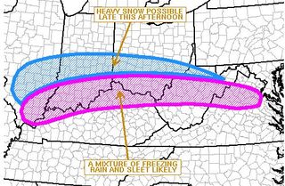
The northward push of the track is compelling to predict an even larger ice storm for folks along the Ohio River than we experienced here last night. As temps continue to balloon up just a bit from the southerly flow (which helping feed this system's moisture), we will likely see rain until about midnight. Then another quick round of freezing rain, sleet and then some snow on the back as colder air finally overrides the upper levels of the atmosphere.
The majority of ice should be north, while we see rain and then a period of snow. I really don't see tonight as major an event for us (Hart, Metcalfe, Barren, Green and surrounding counties) as we experienced Monday night. Temps will plunge quickly, though, around midnight. It's a matter of how much moisture sags behind to be squeezed out of the atmosphere. Maybe an inch or two snow. Hey... that's better than ice. NWS product below...
1pm NWS Advisory For Our Area:
110 PM EST TUE JAN 27 2009 /1210 PM CST TUE JAN 27
2009/ |
POWER Update: There are several thousand area customers without power. Electric lines are down in so many places. It is very difficult for crews to tie up the ends and troubleshoot 1 by 1. They are responding to downed lines and doing so in very tough weather conditions. A source from Farmers RECC tells us that an East Ky Power transmission line problem is the source of many of the area's power outages. Please be patient and have your emergency procedures in place for heat, water and so on. Speaking of water. We've gotten word that some Green River Valley Water customers are without water because of pump/power issues. Many area phone customers are without service because of fallen lines and even some cellular companies are battling power outages at their tower sites. Generators can only run so long until they must be maintained, too.
Hart County is the only School I have at this point on the Closing List. Check back for more updates.
I'll have a forecast tweak at about 4pm.
Send your pics to us. 991@scrtc.com
Keep checking our Closings List.
Chris Jessie
Tuesday, January 27th, 2009...10am
Temps are climbing. We've hit 33 in parts of the area, and ice is meting along with the rain. See the map below for overnight rough estimates of precip. I must say: Our Monday afternoon forecast was pretty close on this one. As some melting takes place today, trees are being cleaned up and power is being restored. I've not heard an estimate on power outages but we've gotten first hand reports from just about every county around us. It seems that more power outages are being reported in Hart County, along with Green and northern Metcalfe Counties. So, what is in store for tonight and tomorrow? We'll continue to fine tune this afternoon, but here's the most recent NWS statement:
Winter Weather Continues Today Through Wednesday
|
...A Winter
Storm Warning is in effect from late tonight through 7 AM EST
Wednesday... South-central Indiana: Mainly sleet with some light snow today changing to all snow after midnight. Additional accumulations of 3-6 inches of snow by Wednesday morning. Any ice accumulations will stay less than a quarter inch. North-central Kentucky/Bluegrass: Snow and sleet changing to mainly freezing rain by midday. Freezing rain will then transition to all snow after midnight. Accumulations of 2-5 inches of snow overnight with one quarter to one half inches of ice accumulations. ...An
Ice Storm Warning is in effect tonight through 1 PM EST Tuesday...
South-central Kentucky: Freezing rain and sleet with change to all rain by late morning and remain rain until around midnight. Additional ice accumulations of up to a quarter inch are possible this morning before the change over to all rain. After midnight...rain will change to snow and 1 to 3 inches of accumulation is possible by Wednesday morning. |
Send your pics to us. 991@scrtc.com
Keep checking our Closings List.
Chris Jessie
Tuesday, January 27th, 2009...9am
Our stations WLOC and WHSX are still off air. WHSX has antenna icing and WLOC has no power at one of the transmission chain sites. We are at mercy of ice several hundred feet off the ground (I'm just not gonna climb the tower today...lol)... and the power company (BTW... hats off to all the line workers, who are putting in their time today.)
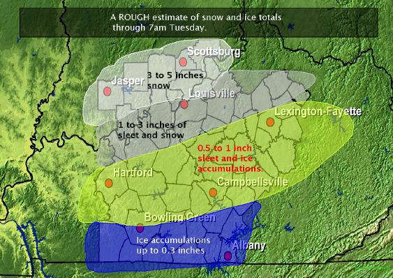
Send your pics to us. 991@scrtc.com
Keep checking our Closings List.
Chris Jessie
Tuesday, January 27th, 2009...7am
Lots of power outages now reported. Trees are snapping under the tremendous weight of the ice. Big story is now starting to shift to tonight's forecast. The potential is there for an event that will make this morning's ice pale in comparison. We will have more on that later today.
Send your pics to us. 991@scrtc.com
Doing quick updates. Schools and college cancellations are now on the list. Keep checking our Closings List.
Chris Jessie
Tuesday, January 27th, 2009...6am
Ice is starting to snap trees and power lines. Lots of reports of roads blocked. Even if you think it isn't slick, the tree round the curve or over the hill can send you into a spin. Power outages are now being reported. Austin Tracy area, Northtown area, LeGrande areas all reporting outages.
Send your pics to us. 991@scrtc.com
Doing quick updates. On air too. Just about everyone is out of school now. No word on colleges as of yet.
Chris Jessie
Tuesday, January 27th, 2009.. 4am
Lots of Ice from freezing rain overnight. The NWS has not moved the Ice Storm Warning boundaries. It remains in effect for us until Noon today. Temps are warming just a bit. The moisture path is also pulling in the warmer air. At 1am, we had 28... official reading from Glasgow airport now is at 32. Temp gradients are pretty tight, dropping as you go further north. Most roads are very slushy. The primary streets have been heavily treated and are responding well. Side/back/secondary streets are another story. Many of them are coated. No widespread power outages have been reported so far. May be some isolated areas.
Temps will warm slightly up as we progress through morning. We should see a changeover to all rain before we see another round of winter precip for tonight and Wednesday morning.
Individual storm reports are being gathered by the Louisville WO and we will have some of those listed a little later on.
Most area schools have cut classes for today. Keep checking our Closings List.
Our 991 station is off the air. I presume ice on the tower has caused a problem. We are working on the issue and appreciate your patience.
More to come.
Chris Jessie
Tuesday, January 27th, 2009... 1am
Just got in from a drive around Metcalfe/Barren/Hart counties. Slush is forming on roads. They are becoming icy, even with the pre-treatments. I've seen road crews going up and down nearly all of the primary roads. Moderate/Heavy rain is falling and then freezing. Elevated surfaces are also beginning to show accumulations. Expect near .5 inch of ice for most of our area, same as the 5pm update I posted below. Temps are anywhere from 27-30 degrees, locally. I would notice a change from hill-top to valley. You could also see the difference in the shimmering of trees/power lines. Not sure if this is going to be an event that causes a lot of damage or not. Rain is kinda heavy to accumulate on tree limbs and lines. Also a breeze is blowing, helping to whip some of the moisture off the surfaces.
No school closings to mention, yet... other than Grayson County and Ohio County. I expect more to be coming, though. Keep checking our Closings List.
More to come. I'm continuing to monitor local conditions and forecast trends for the next 12-24 hours.
Chris Jessie
Monday, January 26th, 2009... 5pm
Here is my 5pm update forecast. Precip is starting to take shape in Southern Missouri and North Arkansas. It will start to move this direction overnight. I still think Midnight for precip start here.
|
Overnight:
Campbellsville, Hodgenville, E-town, Leitchfield... 2-3 inches of snow/sleet and then .25 inch of ice coating Tuesday morning before changing over to rain by midday.
Brownsville, Munfordville/Horse Cave, Greensburg... 1/2 to 3/4 inch of ice from freezing rain... possibly sandpapered with some sleet or occasional snow band before changing over to all rain by mid/late Tuesday morning.
Bowling Green, Glasgow, Edmonton, Columbia... much the same as the Brownsville to Greensburg forecast except a little less... 1/4 to 1/2 inch of ice.
Areas north of that Leitchfield to Campbellsville line... more snow/sleet mix... some heavy snow towards Ohio River and Bluegrass Regions.
Areas south of the Louie Nunn/Natcher Parkway corridors... a rain/sleet mix... more rain and surface temps could certainly produce a glaze of ice but concern may be limited to travel rather than ice coating if trees and powerlines.
|
I'm sticking with this until later tonight. I do expect to tweak it again between 9 and 10pm... we may also see some school closings as local systems try to get the word into the WBKO and Louisville/Nashville TV Station's late newscasts. BUT... you can get it on our station's websites by going to the Closings List Page.
Chris Jessie
Monday, January 26th, 2009...4:45pm
Arkansas Dept. of Highways reporting a large number of ice related accidents on the I-540 corridor. Also... I am monitoring the round of news updates on Louisville TV. The leader is WHAS 11, calling for 6-9 nine inches... WAVE 3 calling 3-5 inches... along with Fox 41... WLKY 32 is saying 4 inches with 1/2 inch of ice.
So, you can see a big variance of opinions even for the same city.
Sorry -- I had a typo on posts from earlier: The last ice storm from our area was in 1994, not 1993.
Ooops.
Chris Jessie
Monday, January 26th, 2009...4pm
Just in from the Tulsa, OK area... Ice glazed roadways are causing some impossible driving conditions. Tulsa airport reads 26 degrees now and freezing rain/fog. Not a good thing.
Chris Jessie
Monday, January 26th, 2009...3:00pm
A shift to the snow track? Snow lines have been moved to the north, although HPC estimates still have Central Kentucky in the heaviest category for overall moisture, not taking into account the type of precip. Sleet will eat up most of this and from E-town-Louisville could see an enormous amount of sleet. Freezing rain south of that. The Ice Storm Warning remains in effect for us here overnight and until mid-day Tuesday. It looks like from the BG / WKY Parkways and south, a total change over to rain will take place by late morning. Transition times here will play a big role in how bad ice accumulation actually is. In the second stage of this system (late Tues. into Wed.), a LOT of moisture could be pulled in from the Gulf. Right now we'll keep a generally same forecast.
As the system's precip kicks up in Arkansas, you'll be able to see a more graphical representation on radar as it moves our direction. I'll have a major update to come early evening.
I was asked in an e-mail about today not getting any colder than about 32 degrees today and shouldn't that give us a better chance of snow? Not exactly. It is true that temps are not getting to the forecast high for today. This is a negative on the side of surface temps. Roads and other exposed surfaces have not warmed up to the near 40 degrees, so when precip starts, it will fall on surfaces that have not absorbed any heat to speak of today other than solar radiation leaking through cloud cover (roads particularly). However, I believe precip will begin no earlier than 10pm to midnight and by then, the solar heat from today would not be a factor for ground temps. They would already cool out from air temps. So, the answer is: It helps snow/sleet/ice "stick" better, but the air mass associated with the system (air aloft) kinda travels with the system and is the determining factor in precip type. So, temps right now can actually continue to rise into the overnight hours.
Chris Jessie
Monday, January 26th, 2009...12:30pm
Some variations are being discussed among various weather outlets. The NWS conference call just before noon pushed the precip timing back a little later into the evening. I believe things are going to be ok until later into the overnight. The 7am NAM is putting the snow/sleet line north of Louisville. That could mean just plain ole rain for us by that time. That also means a shorter but probably heavier burst of snow/sleet to start before the change to freezing rain and rain. So, the tricky part becomes surface temps. This would likely put Louisville and areas just to the south... say to E-town in the position for a SEVERE ICE storm for early morning. Storm track and temperature fluctuations will be vital to the forecast outcome. Here's the latest from NWS forecasting:
| 1137 AM EST MON
JAN 26 2009 /1037 AM CST MON JAN 26 2009/ ...ICE STORM WARNING REMAINS IN EFFECT FROM 10 PM EST /9 PM CST/ THIS EVENING TO 1 PM EST /12 PM CST/ TUESDAY... A MIX OF LIGHT RAIN...FREEZING RAIN AND SLEET WILL BEGIN LATE THIS EVENING BEFORE CHANGING TO ALL FREEZING RAIN AND SLEET AFTER MIDNIGHT ACROSS SOUTH CENTRAL KENTUCKY. UP TO ONE INCH OF SLEET ACCUMULATION ALONG WITH ICE ACCUMULATIONS OF ONE QUARTER INCH ARE EXPECTED OVERNIGHT. AS TEMPERATURES WARM TUESDAY MORNING...FREEZING RAIN WILL AGAIN MIX WITH RAIN AND AN ADDITIONAL ONE QUARTER TO HALF INCH OF ICE ACCUMULATION IS EXPECTED. AN ICE STORM WARNING MEANS SIGNIFICANT AMOUNTS OF ICE WILL MAKE TRAVEL DANGEROUS OR IMPOSSIBLE. TRAVEL IS STRONGLY DISCOURAGED. COMMERCE WILL LIKELY BE SEVERELY IMPACTED. IF YOU MUST TRAVEL...KEEP AN EXTRA FLASHLIGHT...FOOD...AND WATER IN YOUR VEHICLE IN CASE OF AN EMERGENCY. ICE ACCUMULATIONS AND WINDS WILL LIKELY LEAD TO SNAPPED POWER LINES AND FALLING TREE BRANCHES THAT ADD TO THE DANGER. |
BE PREPARED. Road conditions can change very quickly. Have plenty of fuel in your tank incase you get stranded. Remember: NOTHING goes on solid freezing rain covered roads . Be sure you have a charged up cell phone and car charger. Be sure you have battery powered flashlights and radios. Candles can be dangerous, be careful. LED flashlights/free standing lights will last for hours and hours on battery power-- they are a good purchase. HAVE BATTERIES FOR ALL THE ABOVE. Also, be sure you take precautions on electronics that are sensitive to power. In ice situations, a brown-out often can occur. This is extremely hard on computers, home theater equipment and refrigerator/compressors. Surge protectors should be installed on this equipment. UPS power backups are good investments for your computer. And, if a brown-out situation does take place, know how to flip off your home's electrical Main and then power everything down. If you have electric heat and nothing else, be sure you have a way to keep warm. If you have not yet used your gas/wood heat sources this year, now would be a good time to get them ready and use them. And, have some basics... like water and food. In 1994, many Barren County residents were without running water because of the power outages cutting off water utilities' pumping power.
It is not my goal to panic you, but rather to prepare you. Just like with severe storms in spring/summer, winter storms also have ways of crippling our normal routine. We need to have a plan in place and be able to "weather the storm."
One more note: I mentioned 1994 (February).... that is the last major "Ice Storm" we've experienced in this region of Kentucky. In the early 2000's... 01-02 maybe, Lexington and areas in the upper Bluegrass region of the state were hit hard. But, here... it's been almost 16 years. We've been fortunate in that respect. Many people in Hart/Green counties remember February of 1987... some residents in these areas were without power for nearly 2 weeks. Again, be prepared.
Chris Jessie
Monday, January 26th, 2009...9am
Some tweaking in the forecast:
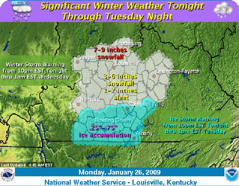
The HPC is also rolling out product for late Tuesday and Wednesday precip that looks like we could have a one - two - punch setup. This map is probability for at least 1/4 inch ice in the second round:
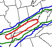 |
%
Chance Of Ice .25" or Greater 10% Probability |
| 40% Probability | |
| 70%
Probability
|
It is beginning to look like we WILL see a winter precip event. The type is going to vary greatly, even within our listening area. North is in shape to receive sleet/snow, and central/south is in line for the possibility of a significant ice storm. The Ice Storm Warning continues to be in effect from 9pm to 12 noon Tuesday. Surface temps are important in this setup. Not so much as to what type of precip, but what happens to it after it falls. Warm air aloft is the key to sleet / rain or snow. The surface temps create an ice storm setup. If rain falls and coats, then re-freezes the "candle dipping" effect takes place. The ice coat gets thicker and thicker.
BE PREPARED. Road conditions can change very quickly. Have plenty of fuel in your tank incase you get stranded. Remember: NOTHING goes on solid freezing rain covered roads . Be sure you have a charged up cell phone and car charger. Be sure you have battery powered flashlights and radios. Candles can be dangerous, be careful. LED flashlights/free standing lights will last for hours and hours on battery power-- they are a good purchase. HAVE BATTERIES FOR ALL THE ABOVE. Also, be sure you take precautions on electronics that are sensitive to power. In ice situations, a brown-out often can occur. This is extremely hard on computers, home theater equipment and refrigerator/compressors. Surge protectors should be installed on this equipment. UPS power backups are good investments for your computer. And, if a brown-out situation does take place, know how to flip off your home's electrical Main and then power everything down. If you have electric heat and nothing else, be sure you have a way to keep warm. If you have not yet used your gas/wood heat sources this year, now would be a good time to get them ready and use them. And, have some basics... like water and food. In 1994, many Barren County residents were without running water because of the power outages cutting off water utilities' pumping power.
It is not my goal to panic you, but rather to prepare you. Just like with severe storms in spring/summer, winter storms also have ways of crippling our normal routine. We need to have a plan in place and be able to "weather the storm."
One more note: I mentioned 1994 (February).... that is the last major "Ice Storm" we've experienced in this region of Kentucky. In the early 2000's... 01-02 maybe, Lexington and areas in the upper Bluegrass region of the state were hit hard. But, here... it's been almost 16 years. We've been fortunate in that respect. Many people in Hart/Green counties remember February of 1987... some residents in these areas were without power for nearly 2 weeks. Again, be prepared.
Chris Jessie
Monday, January 26th, 2009...6am
Roads in the Northern part of our listening area are kida icy this morning... some overnight snow has especially made some bridges and overpasses slick. Please use caution.
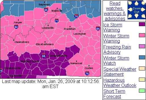
Here's the latest NWS advisory:
...ICE STORM WARNING IN EFFECT FROM 10 PM EST /9 PM CST/ THIS
EVENING TO 1 PM EST /12 PM CST/ TUESDAY...
THE NATIONAL WEATHER SERVICE IN LOUISVILLE HAS ISSUED AN ICE
STORM WARNING...WHICH IS IN EFFECT FROM 10 PM EST /9 PM CST/ THIS
EVENING TO 1 PM EST /12 PM CST/ TUESDAY. THE WINTER STORM WATCH
IS NO LONGER IN EFFECT.
A MIX OF LIGHT RAIN...FREEZING RAIN AND SLEET WILL BEGIN LATE THIS
EVENING BEFORE CHANGING TO ALL FREEZING RAIN AND SLEET AFTER
MIDNIGHT ACROSS SOUTH CENTRAL KENTUCKY. UP TO ONE INCH OF SLEET
ACCUMULATION ALONG WITH ICE ACCUMULATIONS OF LESS THAN ONE QUARTER
INCH ARE EXPECTED OVERNIGHT.
AS TEMPERATURES WARM TUESDAY MORNING...FREEZING RAIN WILL AGAIN
MIX WITH RAIN AND AN ADDITIONAL ONE QUARTER TO HALF INCH OF ICE
ACCUMULATION IS EXPECTED.
AN ICE STORM WARNING MEANS SEVERE WINTER WEATHER CONDITIONS ARE
EXPECTED OR OCCURRING. SIGNIFICANT AMOUNTS OF ICE ACCUMULATIONS
WILL MAKE TRAVEL DANGEROUS OR IMPOSSIBLE. TRAVEL IS STRONGLY
DISCOURAGED. COMMERCE WILL LIKELY BE SEVERELY IMPACTED. IF YOU
MUST TRAVEL...KEEP AN EXTRA FLASHLIGHT...FOOD...AND WATER IN YOUR
VEHICLE IN CASE OF AN EMERGENCY. ICE ACCUMULATIONS AND WINDS WILL
LIKELY LEAD TO SNAPPED POWER LINES AND FALLING TREE BRANCHES THAT
ADD TO THE DANGER.
Chris Jessie
Sunday, January 25th, 2009....10am
There continues to be a lot of debate on this storm system... first it was two different systems... now they've kinda merged the forecasts into a prolonged precip event from Monday night into Thursday. A WINTER STORM WATCH has been issued from Monday night through Wednesday morning by the National Weather Service Office in Louisville.
Just like always... .we are right on the line... rain/sleet/snow, that is. North could see a BUNCH of snow. South could see a major icing event. Still too close to call on a snow total, but for most of us in So.Ky... I say an inch with heavy sleet on top of that. The precip should start as snow then changeover. Temps are very tricky and warm air aloft will determine snow/sleet line. Any shift north in the track puts us in sleet/freezing rain territory, because I think ground temps will be cold enough to cause some problems. A southerly shift will put us in a more snowy category. And.. more of it.
We'll see. As always, check Belski's Blog on WAVE3's site.
Oh... Be sure and send any pictures the next couple of days if we do see a winter wonderland. I'll post them here. So, get your cameras ready and send the pics to my e-mail below.
Chris Jessie
Thursday, January 22nd, 2009...2pm
OK... here we go:
For those of you who want to see snow... Point blank, Monday night / Tuesday morning looks like the best bet at this point. Some moisture will give a chance for winter precip. After that, expect the temps to rise as the bulk of the atmospher's moisture by Wednesday/Thursday is likely to drop as rain... a LOT of rain by mid/late week. Another shot of winter temps should be back after the "rain," just in time to make if feel cold without any snow (next weekend). PLEASE note these latter asumptions are based on model runs that are WAY out.
As for today.... very nice. And, tomorrow will be even better... at least for the temps. Expect 58 maybe even 59 or 60 in some areas. A few scattered showers will also be possible. Then, winter temps return for Saturday, Sunday and Monday before all the precip arrives for next week.
You likely just paid an electric bill for your December service. What will January's bill look like? It's likely to be about the same, just based on weather. (Not taking into account any electric company's rate hike or cut.) The average temps for January is actually above normal just a bit... even though we've had a few days of extreme cold, the overall is +3-5 degrees for much of Kentucky.
More on this to come. I'll be posting every day through the first of next week.
Chris Jessie
Wednesday, January 21st, 2009...1pm
It certainly has felt like winter over the past few days. Get out your flip-flops!!!... here come the 50's!!! Temps will be in the 55 neighborhood for a high on Friday. But, don't get too used to it because winter is on the backside of the weekend. Temps will be back to near normal for Saturday and Sunday. The next weather system will push east by Sunday night/Monday. Later in the week there is a good change that we'll see some significant precip... question is: What kind? The NWS mentioned an ICE STORM possibility. I'm going to back off on putting a foot in my mouth about this one until at least Thursday late or Friday... it's just way too far out. The models continue to flip flop on precipcast. Here's what John Belski (WAVE 3) has to say about it:
From John Belski's blog at WAVE3.com:
Monday system.....everyone seems to be shook up after NWS mentioned ice
storm possibility. I will continue to post NWS comments but will not ramp up
anything past that for a couple of days in case this is another bust.
NWS Louisville:
OVERRUNNING
PRECIPITATION STILL LOOKS QUITE POSSIBLE ACROSS THE LOWER OHIO VALLEY MONDAY
AND TUESDAY. WITH A SHALLOW ARCTIC AIRMASS IN PLACE...A VARIETY OF MIXED
WINTRY PRECIPITATION TYPES ARE POSSIBLE EARLY NEXT WEEK. HOWEVER...WITH A
FLAT ZONAL WESTERLY FLOW AND NO DISCRETE SHORTWAVE OR TROUGH
APPROACHING...ATTEMPTING TO TIME THE PRECIP`S ARRIVAL WILL BE DIFFICULT.
HAVE MADE NO MODIFICATIONS TO THE CURRENT FORECAST FOR MONDAY AND TUESDAY.
NWS Indy:
FOR
THE STORM SYSTEM ON MONDAY AND TUESDAY IT LOOKS UP IN THE AIR AT THIS POINT.
THE GFS NOW IS NOT SHOWING MUCH AT ALL AND 12Z ECMWF WAS STILL SHOWING A
SYSTEM IMPACTING INDIANA. HPC NOTED CONSIDERABLE UNCERTAINTY IN THIS TIME
FRAME AND SO HAVE OPTED TO LET IT RIDE FOR NOW SINCE THE OUTCOME IS STILL
VERY MUCH UNDECIDED.
More on this to come. I'll be posting every day through the first of next week.
Chris Jessie
Friday, January 16th, 2009...7am
It's about 2-3 degrees cooler than at 5am for most temp reports. Several area below zero readings are now being reported. The cold night has created added complications for Louisville firefighters battling two major fires overnight. Check WAVE3's link for amazing details about icing problems as crews work on these blazes.
One more detail.... the crew of the US Airways flight that successfully bellied a plane into the Hudson did an awesome job at getting everybody to safety before the aircraft sank into the river. Also check WAVE's link above for info on it.
Chris Jessie
Friday, January 16th, 2009...6am
Brrrrr..... It's 0 in Munfordville.... 1 in Glasgow...2 in Edmonton.... and it's -1 in Greensburg. There are a couple of school closings to go with the bitter temps. We'll only warm up to about 18 today and fall to about 9 tonight.. Better temps are on the way for the weekend. We should be above freezing tomorrow.
Remember to keep pets protected in this weather. Bang on your vehicle before starting it... Animals like to crawl up into vehicles to keep warm. Be sure they have plenty of food and that their water supply is fresh/not frozen.
More to come.
Chris Jessie
Friday, January 2nd, 2009... 10am
Happy New Year to you. From a weather standpoint, 2008 went out warmly... although it was cold New Year's Eve and overnight, temps rebounded nicely into the 40's on Thursday. We'll see decent temps for the next couple of days, too. The first part of the work week will bring another disturbance to the region. Rain/Snow/Wintry Mix is on the docket as of today's forecast. Enjoy today with a mix of clouds and sun.... highs near 50.
Chris Jessie
Tuesday December 23rd, 2008... 10pm
I'm just now thawing from Sunday night's temps... 7 above here at the station was the low. Wind chill bottom is recorded at -15 here. Lots of rain will stay with us for Christmas Eve... and perhaps change over to a few flurries late. No White Christmas this year. The rain totals may be impressive... 2+ inches are likely. Don't be surprised to hear some thunder again. A wind advisory is also in effect through Wednesday evening. Sustained winds will be near 25mph with gusts at or above 40. No snow is in the forecast, but a cold front could potentially bring strong storms to us Saturday. Here's the forecast outlook from NWS:
.DAYS TWO THROUGH SEVEN...WEDNESDAY THROUGH MONDAY.
WINDY CONDITIONS WILL CONTINUE WEDNESDAY AS A COLD FRONT APPROACHES.
AHEAD OF THE FRONT GUSTS TO 40 MPH WILL BE POSSIBLE. ISOLATED
THUNDERSTORMS PRODUCING GUSTY WINDS WILL ALSO BE POSSIBLE.
ANOTHER COLD FRONT WILL APPROACH THE AREA ON FRIDAY. WINDS WILL INCREASE
OUT OF THE SOUTH WITH SPEEDS OF 20 TO 25 MPH AND GUSTS TO 35 MPH.
A FEW THUNDERSTORMS WILL BE POSSIBLE WITH THE MAIN THREAT BEING
LIGHTNING. THE FRONT WILL PUSH EAST ACROSS THE AREA SATURDAY NIGHT.
WINDS WILL BE STRONG FROM THE SOUTHWEST WITH SPEEDS OF 20 TO 25 MPH
AND GUSTS TO 40 MPH AHEAD OF THE FRONT. STRONG THUNDERSTORMS WILL
ALSO DEVELOP AHEAD OF THE FRONT WITH THE THE MAIN THREATS BEING
STRONG WIND GUSTS AND LIGHTNING.
.SPOTTER INFORMATION STATEMENT...
SPOTTER ACTIVATION MAY BE REQUESTED SATURDAY.
I may not write again until Friday... depending on the outlook with respect to the above NWS statement. Mary Beth, Julianne and me with all of you a Merry Christmas.
Chris Jessie
Wednesday, December 17th, 2008... 12 Noon
Warmer temps for the next several days... Still some rain to deal with, though. Another cold front will likely pass through by Saturday night. As of right now, it doesn't look like a major shot of cold air, but it could trigger some flurry activity into Sunday.
14-17 Day out... Christmas, too... long range puts precip in our region for Christmas Eve... could be rain or snow. Outlook also sees a southward jet stream dip bringing pretty cold temps for the wee between Christmas and New Year's Day. A couple waves of moisture may provide a few chances for snow during the period, also.
Chris Jessie
Tuesday, December 16th, 2008....7:30am
I-65 Shut Down (Northbound) at Munfordville... big pileup. Folks, the roads sound like they are wet... but there is a LOT of ice. Please refrain from traveling unless it is absolutely necessary. We are here at the station watching traffic zip by.... way too fast. Numerous accidents are being reported... the scanner chatter is deafening. Conditions will not improve until mid-late morning. Temps are still 27-28 degrees. Surface liquid continues to freeze. Temps will rise to about 40 today. There is still more precip on the way.
Chris Jessie
Tuesday, December 16th, 2008... 5:30am
The truck is iced over.... I type this as I wait for the defrosters to do their magic. Local temps haven't changed much overnight. We are still in the mid-upper 20's for most everyone. There are several bands of rain/sleet and to the north snow that will be on our menu for most of the morning. MORE ice is expected to accumulate. There is about .1 of an inch out there now. Most vehicles are moving up and down the pre-treated main roads in a timely fashion... that is to say they are still driving too fast. Roads are slick. And, until the 8 or 9 hour, freezing rain will cause even worse conditions. Please avoid driving if you can. Most schools are closed in the area today. See the cancellation page for details.
Chris Jessie
Tuesday, December 16th, 2008... 12am
Just outside my back door, we have a thin layer of ice from freezing rain that began about 10pm. Just to our north the change goes to sleet and by E-town... all snow... an inch of snow as of about midnight (central). The precip runs keep the larger accumulations well to the north... along the Ohio River. Areas between Louisville and Cincy may see 4+ inches by morning. We will continue to see freezing rain and some sleet mixed in. Temps are at 27-28 around most of our area... and ground temps have now fallen below 32. That means that it's all freezing... Went to Glasgow about 8pm and salt trucks were out everywhere. The road crews are doing a good job of preparing for potential driving hazards.
We remain under a winter storm warning until 6pm central Tuesday evening. We could very well see freezing rain continue well into the day on Tuesday. Storm track location will again be very important with regard to how much ice accumulation we get. Bottom line: No significant snow is expected here... only ice. How much??? Louisville WO now says total of about .4 to .5 inches of ice. The rain should stop freezing as the forecast temps have been amended back up to around 40 by noon. I'll have a new update about 6am.
Remember some schools are already on the closed list for Tuesday. Visit the Cancellation List from the station's Homepage.
Chris Jessie
Monday, December 15th, 2008...4:30pm
Temps have been at 32 for some time now. I just checked on surface temps (roads/soil) and just about everything is at 36-37 mark at this point. So, the drive home should continue to be fine. The concern now turns to the major band of moisture that is riding along the Ohio river. Most reports from the < 32 ASOS are reporting rain and sleet. This is not really good. That means snow forming upper levels is melting and falling through a warm level that the cold air is wedging at the surface. As the water hits (depending on the height/altitude of the wedge) freezing surface temps, it re-freezes. If it has enough time, it falls as pellets... sleet. If not it hits the surface and freezes on exposed surfaces. This will be our issue as we head through the overnight and into Thursday morning. Whereas earlier we thought snow might be in place for our northern area, it looks like the snow will even be further north... say Louisville and into So Indiana. That leaves ice/sleet accumulation with little snow potential for central and southern Kentucky.
Trust me... we'd rather have snow. Our Winter Storm Warning has now been extended until Tuesday evening. It looks like the precipitation bands could continue to pass over So/Cen Ky throughout the day on Tuesday and high temps have been amended down... keeping freezing rain and sleet in the forecast for Tuesday. Here's the latest NWS product for our area:
Winter Storm Warning Through Tuesday Evening
...WINTER STORM WARNING NOW IN EFFECT UNTIL 7 PM EST /6 PM CST/
TUESDAY...
AN ARE OF PRECIPITATION WILL MOVE BACK INTO THE REGION TONIGHT
WITH THE HEAVIEST AMOUNTS EXPECTED TO FALL AFTER 4AM. ACROSS SOUTH
CENTRAL INDIANA AND NORTH CENTRAL KENTUCKY A MIXTURE OF SNOW AND
SLEET IS EXPECTED... CHANGING TO SLEET AND FREEZING RAIN LATE
TUESDAY AFTERNOON. ACROSS SOUTH CENTRAL KENTUCKY A MIX OF SLEET
AND FREEZING RAIN WILL LIKELY OCCUR WITH THE PREVALENT
PRECIPITATION BEING FREEZING RAIN. OVER THE BLUEGRASS REGION OF
CENTRAL KENTUCKY A MIX OF SNOW AND SLEET IS EXPECTED TONIGHT...
CHANGING TO ALL FREEZING RAIN BY MID MORNING TUESDAY. THE FREEZING
RAIN WILL CONTINUE THROUGH THE DAY AND GRADUALLY CHANGE TO RAIN
TUESDAY NIGHT.
THE MIXED PRECIPITATION WILL GREATLY AFFECT THE TUESDAY MORNING
AND AFTERNOON COMMUTE. FREEZING RAIN MAY ALSO SNAP POWER LINES AND
TREE BRANCHES. REMEMBER... DO NOT TOUCH A DOWNED POWER LINE.
THIS WINTER STORM WARNING MEANS SIGNIFICANT AMOUNTS SLEET OR
FREEZING RAIN ARE EXPECTED. THIS WILL MAKE TRAVEL VERY HAZARDOUS
OR IMPOSSIBLE.
An ice storm warning is now in effect for portions of middle and western Tennessee.
Chris Jessie
Monday, December 15th, 2008...10:30am
We are now down 18 degrees from 6am... 43 at the studio. Drizzle still falling. Temps expected to fall to mid 20's by about 4pm. Precip will lighten up as cold air squeezes out moisture. Round two will be later tonight where the Louisville W.O. still is saying 1-4 inches of snow... more snow north, mix in mid-state and ice in SoKy-north Tennessee.
I'll be writing more throughout the day.
Chris Jessie
Monday, December 15th, 2008...6am
Right now it's 61 at 6am.... this number will be a wish by later this afternoon. An artic blast has plunged into the country's midsection and has completely escaped the long range forecasts. As of early Sunday morning... temps weren't even expected to really get below freezing this week. But, the newly re-tuned short forecast now puts us in a Winter Storm Warning. Temps will plunge very quickly this afternoon. A changeover to a mix of frozen precip could create impossible travel conditions for late today and Tuesday morning. Be sure you are prepared with plenty of gas in your vehicle and batteries in the even of a power outage. Major ice accumulation is not expected at this time... the Louisville W.O. is calling for 1-4 inches of snow and ice accumulation. But, as we witnessed Friday in the upper north-east... surprises can happen.. So, be prepared and be sure you've checked in with elderly neighbors and relatives that may need help should they lose power.
I'll be writing more throughout the day.
Chris Jessie
Friday, November 28th, 2008... Noon
I actually stopped eating yesterday when I became full. I didn't overeat. This is a major step toward my News Year's resolution. I hope all of you had a great Thanksgiving.
We continue to look at the snow outlook for late weekend. Sunday's highs look warmer... so it doesn't look like any snow until late Sunday night. However, we need to be careful Saturday night... rain and temps at about 32... may be a freeze situation late. Ground temps will be warm enough on Saturday that 32 may not be a problem. Either way... be careful.
As for snow amounts... The NWS (Louisville) is not placing any accumulation values yet. However, they do say accumulations are likely. The 850mb atmospheric level shows a low over the southern part of the state late Sunday/Monday (NAM and GFS are fairly close) which means lighter snow amounts will be found on the backside (to the north). With that being said, WAVE 3's John Belski suggests about 2 inches on the backside/Louisville area. As for here and based on the current low track, we should see more snow than Louisville, with the state's heaviest amounts in the Somerset to London to Berea corridor. WBKO's Jason Berry's outlook says, "...some accumulation possible - though nothing significant." We'll have to see if the current storm track stays or changes.
This storm is not just about the low. Lower level moisture is expected to remain in place through Monday, which combined with the temps will tack on more snow showers to the forecast even as the system moves east.
More to come later today.
Chris Jessie
Thursday, November 27th, 2008... 10am
Snow...? A lot of Snow...? Well, the Thanksgiving conditions here are nice... sunny and upper 50's... but the weather community is talking more about late weekend and the first day of December. Some forecasters are interpreting forecast models and predicting a significant snow storm for the Ohio Valley late weekend/early week. After looking at a combination of different model outputs, I am leaning on a East Coast snow storm with no huge effects here.
With that being said...
My snowcasts were mostly on the negative side last winter, so... I'm reworking through some winter meteorology theories and studies. I also am changing my choice of model to rely more heavily on... (for those of you in the WX community, I've been partial to the Eta/GFS's DGEX output in the past but it hasn't provided 3+ day reality for our area of the country.)
In my opinion, John Belski at WAVE 3 in Louisville is the best. He's not jumping on the snow bandwagon, yet. But he points out the forecasters who are. Check out his weather blog HERE.
As for me... "Let It Snow, Let It Snow."
Happy Thanksgiving!
Chris Jessie
Tuesday, November 25th, 2008... 11am
Snow showers in November have been rather common over the last couple of weeks. At least four different occasions have been reported with last night's flurry activity. Tonight's colder temps will give way to warming by Thanksgiving Day. With a lot of sunshine, highs on Thursday should actually be in the lower 50's. Back yard football ought to be a no brainer this year!... Work off all that extra carb intake.
Happy Thanksgiving!
Chris Jessie
Wednesday, November 12th, 2008...1pm
Rain, Rain.... nice to see in one respect. And, it's going to stay with us through the rest of the week. Temps remain on the comfortable side until the weekend. Saturday, get ready for our first dose of really cold weather this season as arctic air plunges south and into the state. There continues to be a flirty forecast with respect to any freezing precip. Forecast model runs are showing a moderate amount of low level moisture hanging around through late Saturday and then colder/dryer conditions early Sunday. Depending on surface level temps, a trace of snow is not out of the question...and if temps fall quickly enough. Certainly some sort of mixed precip late on Saturday is a strong possibility. Even though it's really nothing significant on the snow end, it certainly is a dose of reality... warm weather is over for the year.
I'll be in Indianapolis this weekend for Bands of America Grand Nationals Competition. Good luck Hart County Raider Marching band and LaRue County Hawks Marching Band. We'll try to update things here on the home-front and also tell you how cold it is in Indy!
Chris Jessie
Monday, November 10th, 2008...1pm
What a beautiful Fall in SoKy! I believe color and leaf change has been more spectacular this year than any I can remember. Or... maybe I just don't remember things that well from year to year. We are past peak, now. The Smoky Mountain National Park is also drawing more oohs and ahhs than usual, with vivid color. I'd love to see your Fall pics!!! Send them to nitehawk@scrtc.com
On the weather: That fall rain (that I mentioned not having this year) will set in as we go into the next 24. Things could stay wet all the way into the weekend and end up in with snow showers on Saturday night. It's the first time we've used the "S" word in the forecast this year. Looking back to week before last, we did have a couple of early morning reports of flurries. And, on that same morning northern Kentucky reported some show showers.
Chris Jessie
Wednesday, November 5th, 2008...1pm
Today and Thursday may be the final two very nice weather days we see this year. Sunny and 75 won't be a common forecast into the last of November and December. On a good note: We do need the rain. A cold front will trigger showers and some thunderstorms late Thursday / early Friday. No severe weather is expected... and this will not be a major rain maker. After the front passes, much cooler air will push in. Highs will be in the mid 50's over the weekend and push up to near 60 by Veteran's Day on Tuesday.
Be sure and check out our look back at the Munfordville Tornado of November, 2005... Click Here.
Chris Jessie
Friday, October 31st, 2008...9:30am
The weekend is looking Marvelous... Sunny and lower 70s for the 1st week of November! Who needs Florida! There is now a rain chance in the 7-day... about next Thursday. We still need the precip.
I often get questions this time of year about the "winter outlook." There are (in general terms) two schools of thought. One is a "Farmer's Almanac" type which is based on history, folklore and signs of nature. The other is based on charts, maps and meteorological phenomenon. I tend to blend the two... and then discard them both. This time of the year and in the spring, things are moving so fast with regard to changing weather patterns. While some theories like El Nino and La Nina are real and do add to predictability of our weather, some theories are simply "shot in the dark" guesses. If you look at one climatologist's forecast... it's going to be a cold and snowy winter... another with the same credentials will say a warm and wet winter. So, there is something to be said for the reasoning that yields these forecasts. It's just that snowfall is the most difficult prediction to make in our region of the world. You hear me say this a lot in my winter/snow forecasts. A degree or two difference at a given atmospheric level can yield a huge variety of surface results. This winter, I say: A bit colder than normal and dryer than normal... 2 Major snows (3 inches or more)... and 1 moderate icing event. While I'm at this... my Power Ball Lotto numbers are 1-11-23-25-32 and 48. Good luck to me on both.
Chris Jessie
Thursday, October 30th, 2008...1:30pm
After two nights in a row of below freezing temps, a warm up is coming. Temps now are reading into the lower 60's and will climb to near 70 tomorrow and a little above for the weekend. This is perfect October weather. We are still very dry, though... with only about 4 days of rainfall this month.... which is deepening our rainfall deficit for the year. Good day to wash the car! Bugs are nearly gone and there is no rain in the 7-day... so it should stay sparkly for a few days.
Chris Jessie
Tuesday, October 28th, 2008... 11am
First freezing temps of the season can be expected tonight. Temps are forecast in the upper 20's for most of SoKy... but a few mid-20 readings will likely be observed. Any vegetation that is susceptible to frost should be moved into an above freezing environment. This will likely be a "killer" frost, meaning the end of the growing season for 2008.
Temps will moderate on Wednesday into mid-50's and the upper 60's should return by late week. Weekend looks pretty good from this standpoint.
Chris Jessie
Thursday, February 21st, 2008... 3pm
Temps are coming up more slowly than the forecast runs indicated. We are still at 28. Temps in Louisville are 27 and BG is at 30. Light rain is coming down again.... a larger patch in the Northern Barren County area. It is making the ice already down on the roads even more slick in some cases. Imagine holding on to an ice cube... now a wet ice cube... get the difference? Rain = Not good. Most of the heavier freezing rain is still well off to the north. We'll still see the possibility of some freezing rain in the evening hours, but I still see the temps rising to above freezing.
Thursday, February 21st, 2008... 1pm
I believe we've seen the worst of the ice/freezing rain. Temps will continue to slowly rise... even overnight. All rain overnight and for Friday. Problems this afternoon shouldn't be as drastic as this mornings commute. The temps should be right at the freezing mark. However, on the northern side of our area, the temps could still be cold enough for freezing rain to be a problem. Friday morning really shouldn't be a problem as rain and the road treatments do their jobs. I'll post more this afternoon late as temps continue to rise.
Thursday, February 21st, 2008... 9:30am
Freezing rain continues.... roads are impassible in some areas. We are taking a look at temps forecasts... they are changing with lower highs now being expected. That is not good news for the freezing rain. We'll continue to post more.
Thursday, February 21st, 2008... 8am
DONT DRIVE TODAY IF YOU DONT HAVE TO BE ON THE ROADS... Numerous accidents are already being reported.
Freezing rain now reported in our area.... roads are getting very slick... please don't travel if you don't have to be out... rain is starting earlier than anticipated and is moving quickly from w. ky into our area. please stay tuned to our stations for the latest info... it will be hard for me to post often here with all that is going on.
Wednesday, February 20th, 2008... 4pm
Before the weather... Congrats to NASA and the Space Shuttle Crew on a safe return from a successful mission to the international space station. The shuttle touched down just after 8am central time this morning. Tonight... check the total eclipse of the moon... skies should be clear enough to see at least part of the event which will begin in our part of the country at about 7:45. The totality will last just under an hour from about 9pm to 9:50pm central time. Should be a great view with the naked eye an amazing sight with a good set of binoculars.
NOW... For the possibility for more winter weather... It looks like precip in our area will begin between 1-4pm.
The questions are: How will it fall and how much will it amount to?
The maps here show the HPC ice forecast for Thursday. Below that,
you'll see the surface low forecast map... notice the low in the upper
Mississippi valley... the anticipated late Thursday position... here is the moisture pump for the system. There is still some uncertainty as to
exactly where the snow/sleet/freezing rain/rain divides will be.
Here's what today's 4pm (est) NWS advisory says...
moisture pump for the system. There is still some uncertainty as to
exactly where the snow/sleet/freezing rain/rain divides will be.
Here's what today's 4pm (est) NWS advisory says...
...WINTER STORM WATCH IN EFFECT FOR ALL OF CENTRAL KENTUCKY AND SOUTH-CENTRAL INDIANA FOR THURSDAY AFTERNOON THROUGH FRIDAY MORNING...
.A STRONG WEATHER SYSTEM IS FORECAST TO IMPACT THE AREA BEGINNING THURSDAY
AFTERNOON. THIS SYSTEM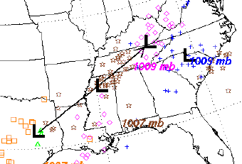 HAS THE POTENTIAL TO BRING SIGNIFICANT ICE ACCUMULATIONS TO PORTIONS OF THE
AREA.
HAS THE POTENTIAL TO BRING SIGNIFICANT ICE ACCUMULATIONS TO PORTIONS OF THE
AREA.
THE LATEST WEATHER FORECASTS INDICATE THAT A
SIGNIFICANT STORM
SYSTEM WILL AFFECT MUCH OF THE REGION MAINLY BETWEEN THURSDAY
AFTERNOON AND EARLY FRIDAY MORNING. THE PRECIPITATION WILL LIKELY START AS A
LIGHT SLEET OR SNOW MIX ACROSS WEST-CENTRAL KENTUCKY AND SOUTHWEST INDIANA
THURSDAY AFTERNOON. THIS WILL QUICKLY CHANGE
OVER TO FREEZING RAIN BY THURSDAY EVENING. ICE ACCUMULATIONS ARE
POSSIBLE MAINLY NORTH OF A LINE FROM HARTFORD...TO BARDSTOWN AND
TO WINCHESTER KENTUCKY. THE MOST SIGNIFICANT ICE ACCUMULATIONS
WILL BE ALONG AND NORTH OF THE OHIO RIVER. LOCATIONS ACROSS SOUTH-
CENTRAL KENTUCKY WILL RECEIVE MOSTLY RAIN...THOUGH LIGHT FREEZING
RAIN IS POSSIBLE AT PRECIPITATION ONSET LATE THURSDAY AFTERNOON.
THIS STORM SYSTEM HAS THE POTENTIAL TO CREATE VERY HAZARDOUS
TRAVEL CONDITIONS THURSDAY NIGHT...MAINLY BETWEEN 7PM EST THURSDAY
NIGHT THROUGH 3AM EST FRIDAY MORNING. AGAIN...THE MOST SIGNIFICANT
WINTRY MIX WILL AFFECT SOUTH-CENTRAL INDIANA...NORTH-CENTRAL
KENTUCKY...AND THE NORTHERN BLUEGRASS REGION.
THERE IS STILL QUITE A BIT OF UNCERTAINTY WITH REGARDS TO THE
LOCATION AND AMOUNT OF THE MOST SIGNIFICANT ICE POTENTIAL.
Keep checking back, gang... I'll make more posts when possible and needed. Please stay tuned to WLOC/WHSX and here on the website for the latest.
Tuesday, February 19th, 2008... 2pm
Last week, Louisville and areas along the Ohio River got the
snow... who will get it this week...??? It looks like a trace will be
possible as we head into Wednesday morning... the bigger story is
Thursday/Friday. The potential exists for a major winter storm in
Central/Northern Kentucky. The NWS discussions on this are not going to
change much with the exact track of the system still uncertain. However, the
current HPC freezing rain forecast has us in a slight probability for at
least .25 inch ice accumulation. The temps forecast for Thurs/Fri continue
to waiver. I would not call it a sure shot until at least late tomorrow
night. With all that said... remember that winter weather is still the most
difficult forecast to accurately produce. There are so many variables that
go into when, how much and what type of precip. Most of the time, forecasts
more than 12 hours out will most always be changed significantly. And, most
of the snow total forecasting that is accurate is only hours out... because
radar is a valuable tool in seeing where snow bands move and where the lower
level moisture is getting pumped in. I'm going to keep an eye on this one.
Could be nothing... but, we've not had a large scale ice event here since
February 1994. Most people can remember February 1987... major ice storm.
Had a smaller ice coating in January 1999. We are due.
Thursday, February 7th, 2008... 2pm
First off... My prayers are with those who lost loved ones and for those who
suffered great loss of property Tuesday night and early Wednesday morning.
I am just recuperating, myself from a 6 hour broadcast of the storm.
I've not had a chance to sit down and post any of my thoughts on the events
until now. I do want to say thanks for the e-mails and calls from
those of you who have let me know you appreciate me broadcasting thorough
all the chaos. I am proud to say that with the help of NWS alerts from
Nashville and Louisville, we were able to give about a 15 minute advance
warning to the communities of Gamaliel, Ebenezer, Tompkinsville and others
in Monroe County. As that storm came out of Macon County, Tennessee,
we knew it had a history of major damage. We were able to successfully
project the path of the of the EF-3 vortex. The second EF-3, the one
that caused the damage is Allen County, was similar in nature, taking a path
only about 10-15 miles north and parallel to the first tornado's path.
That storm caused the fatalities in Allen County and the tornado damage
stopped just short of the Fountain Run area. Below is the official
storm report form NWS survey teams... Also take note of the radar shot from
10:30 with the tornado centered right over the Gamaliel area:
...INITIAL DAMAGE SURVEY OF TWO EF-3 TORNADOES IN
SOUTHERN KENTUCKY...
ON WEDNESDAY FEBRUARY 6 2008 A NATIONAL WEATHER SERVICE DAMAGE SURVEY TEAM
TRAVELED THROUGH PARTS OF ALLEN AND MONROE COUNTIES IN SOUTH CENTRAL
KENTUCKY TO VIEW THE EFFECTS OF TWO TORNADOES WHICH STRUCK THE AREA DURING
THE LATE EVENING AND EARLY MORNING HOURS OF FEBRUARY 5-6. THE SURVEY
REVEALED TWO EF-3 TORNADOES HAD OCCURRED...SEPARATED IN DISTANCE BY
APPROXIMATELY 5 MILES...BUT IN TIME BY APPROXIMATELY 3 HOURS.
THE FIRST TORNADO CROSSED INTO MONROE COUNTY KENTUCKY FROM TENNESSEE AT
APPROXIMATELY 1030 PM CST 3.5 MILES SOUTHWEST OF THE TOWN OF GAMALIEL. THE
TORNADO RACED NORTHEAST AT 60 MPH...DESTROYING TWO MOBILE HOMES AND TWO
CONVENTIONAL HOMES 2 MILES WEST OF
GAMALIEL. THIRTEEN RESIDENTS OF THE FOUR HOMES TOOK SHELTER IN THE
BASEMENT OF ONE OF THEM...AND SURVIVED UNINJURED...THOUGH THEY WERE
TRAPPED IN THE BASEMENT FOR UP TO 30 MINUTES BEFORE THEY WERE ABLE
TO DIG THEMSELVES OUT THROUGH THE RUBBLE.
THE TORNADO ALSO DAMAGED SEVERAL OTHER HOMES IN A SUBDIVISION 1
MILE NORTH OF GAMALIEL...INCLUDING TAKING THE ROOF OFF OF A BRICK
HOME...AND STRIPPING THE BRICK FROM SEVERAL OF THE WALLS. THE
TORNADO CONTINUED ON A NORTHEAST TRACK OVER RURAL
COUNTRYSIDE...PRIMARILY UPROOTING AND SNAPPING LARGE TREES IN THE
HEAVILY WOODED AREA AS IT HEADED TOWARD TOMPKINSVILLE. ON THE
NORTH SIDE OF TOMPKINSVILLE, THE TORNADO COMPLETELY DESTROYED A
LARGE WOOD-FRAME METAL WAREHOUSE AND TWISTED A LARGE STEEL-FRAMED
METAL BUILDING OFF ITS FOUNDATION AND COLLAPSING HALF THE BUILDING.
IMMEDIATELY ACROSS THE HIGHWAY FROM THE TWO INDUSTRIAL
BUILDINGS...A WELL BUILT BRICK HOME AT THE TOP OF A HILL WAS LEFT
WITH ONLY A FEW INTERIOR WALLS REMAINING AS ITS ROOF AND SIDE
WALLS WERE SWEPT AWAY. A NEARBY DETACHED 3-CAR GARAGE WAS ALSO
DESTROYED.
TORNADO DETAILS...KNOWN AT THIS TIME...
MONROE COUNTY TORNADO
PATH LENGTH: 12+ MILES
PATH WIDTH: 0.25 MILE
RATING: EF-3
MAXIMUM WIND SPEED: 160 MPH
INJURIES: NONE KNOWN
FATALITIES: NONE
START TIME: MOVED IN FROM TENNESSEE AT APPROXIMATELY 1030 PM CST
END TIME: NOT YET DETERMINED. SURVEY TEAM WILL COMPLETE TRACK THURSDAY
......................................................................
THE SECOND TORNADO TOUCHED DOWN JUST OVER ONE-HALF MILE NORTHWEST
OF HAYESVILLE ABOUT ONE-QUARTER MILE NORTH OF THE STATE LINE. THE
TORNADO MOVED NORTHEAST AT AROUND 55 MPH AND DESTROYED A MOBILE
HOME 1 MILE NORTH OF HAYESVILLE. IT ALSO HEAVILY DAMAGED A NEARBY
CONVENTIONAL HOME...DESTROYED AN OUTBUILDING AND OVERTURNED
ANOTHER NEARBY MOBILE HOME ONE-QUARTER MILE TO THE NORTH.
CONTINUING NORTHEAST...THE TORNADO WIDENED TO NEARLY ONE-HALF MILE
ACROSS AS IT DESTROYED 5 MOBILE HOMES AND 3 CONVENTIONALLY BUILT
HOMES...ALONG WITH NUMEROUS LARGE OUTBUILDINGS ALONG TRACY LANE
AND TRACY ROAD. 4 RESIDENTS WERE KILLED IN 3 SEPARATE MOBILE HOMES
IN THIS AREA AND 4 OTHERS WERE INJURED. SEVERAL HORSES AND OTHER
FARM ANIMALS WERE ALSO KILLED.
THIS TORNADO CONTINUED MOVING NORTHEAST OVER HEAVILY WOODED RURAL
AREA BEFORE WEAKENING AND DISSIPATING NEAR FOUNTAIN RUN IN
WESTERN MONROE COUNTY.
ALLEN COUNTY TORNADO
PATH LENGTH: 9 MILES
PATH WIDTH: 0.4 MILE
RATING: EF-3
MAXIMUM WIND SPEED: 160 MPH
INJURIES: 4 KNOWN
FATALITIES: 4
START TIME: APPROXIMATELY 140 AM CST
END TIME: APPROXIMATELY 153 AM CST
Tuesday, January 29th, 2008... 8:20pm
Wow... tonight was one of the quickest storm lines I've seen in a while. The winds have been unofficially tagged at 75+ miles an hour in some areas of South Central Kentucky. We will see temps drop very quickly over the next 2 hours... down to freezing even. We were at about 59 degrees before 7pm. Some light winter precip may take place tonight... no major problems are expected. Remember to send any damage reports to local officials and then please send them to us. Video/Pics are also welcome... send large files to this address 991@thehoss.com ... send text only reports to our normal address: 991@scrtc.com.
Monday, January 28th, 2008... Noon
Wow... as mentioned earlier this morning... a big back and forth swing is coming over the next 24-48 hours. Here's a Special Statement from The NWS, Louisville:
...STRONG THUNDERSTORMS AND GUSTY WINDS EXPECTED
TUESDAY AFTERNOON AND EVENING...
THE LATEST FORECASTS INDICATE THAT A VERY STRONG STORM SYSTEM WILL
DEVELOP AND GATHER STRENGTH ACROSS THE MIDWEST TODAY. THIS STORM
SYSTEM IS FORECAST TO MOVE INTO THE WESTERN OHIO VALLEY LATE
TONIGHT AND TUESDAY. WIDESPREAD SHOWERS ARE EXPECTED TO DEVELOP
TONIGHT AND OVERSPREAD THE REGION.
DURING THE DAY ON TUESDAY...SHOWERS ARE FORECAST TO CONTINUE
ACROSS THE REGION. AS THE STORM SYSTEM APPROACHES...SURFACE WINDS
WILL GRADUALLY INCREASE THROUGHOUT THE DAY. SUSTAINED WINDS OF 20
TO 25 MPH WITH GUSTS TO 35 MPH WILL BE POSSIBLE ACROSS MUCH OF
SOUTHERN INDIANA AND CENTRAL KENTUCKY BY TUESDAY AFTERNOON.
A STRONG COLD FRONT ASSOCIATED WITH THIS STORM SYSTEM WILL PUSH
INTO WESTERN KENTUCKY EARLY TUESDAY EVENING. THIS FRONT WILL
LIKELY PRODUCE A LINE OF SHOWERS WITH EMBEDDED THUNDERSTORMS. WITH
STRONG WIND FIELDS ALOFT...SOME OF THE THUNDERSTORMS MAY TAP INTO
THIS FAST MOVING AIR AND TRANSPORT IT TO THE SURFACE. WIND GUSTS
OF 40 TO 45 MPH WILL BE POSSIBLE AHEAD OF THIS FRONT. AS THE FRONT
MOVES EAST...WINDS WILL QUICKLY SHIFT TO THE NORTHWEST AND
CONTINUE TO BE QUITE STRONG. WIND GUSTS OF 40 TO 45 MPH WILL BE
POSSIBLE UP TO TWO HOURS AFTER THE FRONT PASSES THROUGH THE AREA.
THESE GUSTY NORTHWEST WINDS WILL ALSO BRING IN MUCH COLDER AIR TO
THE REGION. SOME OF THE PRECIPITATION BEHIND THE FRONT MAY CHANGE
TO A PERIOD OF SNOW. SOME VERY MINOR ACCUMULATION MAY BE POSSIBLE.
Rain, heavy t-storms, snow.... Only in Kentucky, Right? Also, on this date, we look back to the Great Flood of 1937, where 15 inches of rain fell over a 12 day period. As much as 70% of Louisville was under water. Click Here for the NWS page of info about the historical event.
Check out this pic... (Located On NWS Page Link)
The horse up in the tree was caught by the tree and it became stuck there as water subsided.
Monday, January 28th, 2008... 8am
Another cold morning across the region... we recorded 21 as our low this morning. A big turn around is on the way for 24 hours. Today, temps will shoot into the upper 50's... and heavy rain/thunderstorms are possible Tuesday. Gusty winds will also be with us. It will be a quick warm up with short lived above normal temps, as we return to the 30's for a high on Wednesday. Then, we make way for the next big system for late Thursday/Friday. Most current GFS models show a rain event rather than snow. I will be posting more later.
Thursday, January 24th, 2008... 3pm
It's been a while since I've made a post... sorry 'bout that. Time is so critical here where a few people wear so many hats. Anywho...
We started at midnight with our warmest temp at 29 (Bowling Green/Official) and at 6am, we were at 25. After daybreak, temps continued to drop to 20 by around 9am. Temps have held in the lower/mid 20s for the day. We also bottomed out with the barometer at midnight... with pressure rising today. This will take the blanket off the ground temps for tonight, as we bottom out in the mid/upper single digits around daybreak in the 6-7am hour for Friday morning. It won't be out of the question to see an isolated reading near the 3-4 degree mark. A northerly light breeze will gradually shift to a southerly flow by late afternoon and that will set the stage for a warming trend for the weekend.
We've seen initial forecast after initial forecast for snow diminish and eventually dissipate to either rain or no moisture at all. After today and tomorrow's cold temps, we'll see things warm back up into the weekend. As a matter of fact, high temps on Sunday will be back into the 55 degree range. But... not before a chance of some snow showers Friday night into Saturday morning. Cold air will be retreating... it doesn't look like we'll see any significant moisture filtered in to get a high probability of precip.
Check out tonight's near full moon rise... about 7:20 to about 7:40 it should be huge. Get your cameras out and send me pics!!!! nitehawk@scrtc.com That's my personal address... By the way... send me weather/atmospheric pictures anytime!!! I'll post them here on my Weather discussion.
And... with all this talk about cold and snow, for those of you who can't wait 'till summer... we're making tracks to longer days and shorter nights. The days are stretching out by about 1 minute 45 seconds of daylight each 24 hour period. That daily margin continues increasing, too. That should give us about another hour of daylight by the back half of February.
Snuggle up and stay by the fire tonight!!!!